During the recent hot spell in May, I launched a mighty Twitter rant about the dearth of cycle commuters in Belfast. I was fairly challenged on a number of assertions about Belfast’s population and commuter flows. Having subsequently had a little time to look over available data, there are some clear conclusions to be drawn about the possibilities of modal shift in Belfast – getting punters to give up car travel in favour of the humble bike.

Continue reading “Belfast: a city with untapped cycle potential”

Leisure and tourism in County Tyrone could be boosted by reopening a former railway line as a cycling and walking route. The Great Northern Railway branch line ran from Cookstown, through Coalisland and into Dungannon. Built in 1879, fully enclosing the Lough Neagh basin with railway lines, this branch was closed in 1959.  Creating a new Greenway for walkers and cyclists, local ramblers and active tourists, can create new economic possibilities and health benefits in the region.

Continue reading “Cookstown to Dungannon Greenway”

The towns of Cookstown, Moneymore and Magherafelt were once linked by a railway that now lies derelict. The old line, which winds through the Mid Ulster countryside, could be regenerated to provide a high quality 11 mile walking path and cycle route. This could be an important part of an orbital pathway around Lough Neagh, and a key tourist route west of the Bann.

CookstownMagherafelt

Continue reading “Cookstown to Magherafelt Greenway”

Magherafelt, Draperstown and Desertmartin are linked by the former Draperstown Railway, which shut in 1950. Local communities could benefit from regenerating this route and creating a new Greenway to allow walking and cycling into the County Tyrone countryside. This Greenway proposal is part of a wider network over 600 miles across Northern Ireland which, if realised, could bring activity tourism spend to the Draperstown area.

Continue reading “Magherafelt to Draperstown Greenway”

Former Ballymoney to Ballycastle railway

I wrote to the Countryside Access and Activities Network (CAAN)  to highlight this blog. They are currently seeking responses to 9 Issue Papers which will feed into the development of a Northern Ireland Outdoor Recreation Action Plan 2012-21. I received a very encouraging response, and I would urge anyone with an interest to contribute to the debate. The issue papers can be viewed on the Outdoor Recreation Northern Ireland website.

Continue reading “NI Outdoor Recreation Action Plan”

Potential exists to construct a Greenway from Toome to Magherafelt, on the disused trackbed of the former Belfast and Northern Counties Railway. This important link in an orbital traffic-free path around Lough Neagh could bring valuable tourist spend to Toome, Castledawson and Magherafelt.

The proposed Greenway route begins by linking with another suggested Greenway tracing Lough Neagh to Randalstown. Holding a straight line for the 4 miles to Castledawson, the route has remained mostly undisturbed as seen from satellite imagery. Occasional agricultural land development and industrial buildings encroach onto the former line, but slight alterations and landowner negotiations could resolve these issues.

Continue reading “Toome to Magherafelt Greenway”

A new Greenway connecting Randalstown and Toome is a project which could bring health and leisure benefits to the local population, and be a key tourist link on the north shore of Lough Neagh.

RandalstownToome

This was the route which first interested me in the former railway lines in Northern Ireland. The railway viaduct dominates the eastern approach to Randalstown, which in recent years had been redeveloped to provide a scenic walkway. This was a link across the River Maine for the Belfast and Northern Counties railway line stretching from Antrim, through Randalstown to Toome and onwards to Magherafelt. I traced the route on Google Maps and began to think of this entire proposal.

Continue reading “Randalstown to Toome Greenway”

DPNCroute
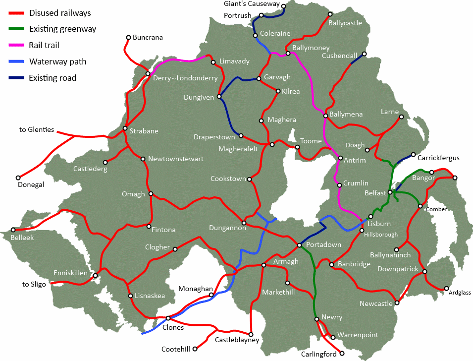
Completing the main line of the former Belfast and County Down Railway, there is potential to open a 10-mile dedicated cycle and walking path from Downpatrick to Newcastle. Opening access to the Mourne countryside can help to encourage active tourism and encourage healthier lifestyles in Northern Ireland.

Starting from the working heritage railway in Downpatrick, the track bed heads out following near the line of the Ballydugan Road towards Clough. As the proposed pathway crosses the A25, there is potential for linkages to Clough, Seaforde and its Gardens and Tropical Butterfly House. The line then turns South West towards Dundrum Bay, beginning one of the most spectacular walkways Northern Ireland could boast. The old line hugs the coast, extending into the bay at one point (see picture). Dundrum Bay lies at the edge of the Murlough Bay Nature reserve, lending some wonderful tourism potential to the route.

Continue reading “Downpatrick to Newcastle Greenway”

A new pedestrian and cycling greenway route through Downpatrick would link the historic town with Belfast, and provide a quality tourist trail from Northern Ireland’s captial city to the Mourne Mountains.

[googlemaps http://maps.google.co.uk/maps/ms?msa=0&msid=202802535379582075161.0004bea4e6d2981bee4d5&hl=en&ie=UTF8&t=p&ll=54.33094,-5.682678&spn=0.240231,0.822601&z=10&output=embed&w=600&h=300]

Continue reading “Downpatrick & Ardglass Greenways”

The best place to start detailing the vision for a network of Northern Ireland Greenways is with a town already benefiting from a traffic-free cycling and walking path, the 7 mile Comber Greenway. This popular route traces the old Belfast and County Down line with minor diversions to account for interim development. The Comber Greenway is heavily used for walking, leisure cycling and commuting, and includes a number of nodes such as the Billy Neill Soccer Centre of Excellence, the retail and business park at Dundonald, and a direct link into the heart of Belfast.

Continue reading “Comber to Ballynahinch Greenway”