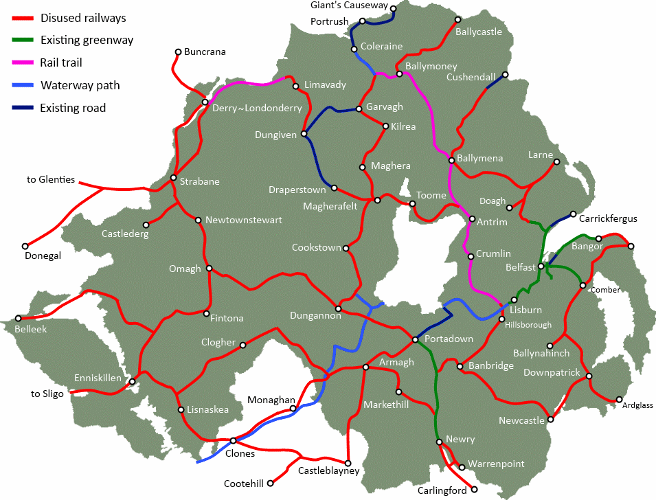
A new Greenway connecting Randalstown and Toome is a project which could bring health and leisure benefits to the local population, and be a key tourist link on the north shore of Lough Neagh.

This was the route which first interested me in the former railway lines in Northern Ireland. The railway viaduct dominates the eastern approach to Randalstown, which in recent years had been redeveloped to provide a scenic walkway. This was a link across the River Maine for the Belfast and Northern Counties railway line stretching from Antrim, through Randalstown to Toome and onwards to Magherafelt. I traced the route on Google Maps and began to think of this entire proposal.
[googlemaps http://maps.google.co.uk/maps/ms?msa=0&msid=202802535379582075161.0004bf78a520742f602b9&hl=en&ie=UTF8&t=m&layer=c&cbll=54.749129,-6.317112&panoid=lNjUGX3QMnQdvpd5kfhYIQ&cbp=13,214.94,,0,-3.46&source=embed&ll=54.732104,-6.317139&spn=0.05947,0.205994&z=12&output=svembed&w=600&h=300]
A fully traffic-free walking and cycling 9 mile route from Randalstown to Toome would be popular with local ramblers and leisure cyclists, but could also prove a draw for active holiday tourists. Heading south out of Randalstown, the Greenway route would pass the edge of Randalstown Forest, potentially reducing some local car travel to this spot. World of Owls is also within reach within the forest.
A little further on the route passes close to the Lough shore, and an optional spur to Churchtown Point at Cranfield could both exploit cycle tourers and day ramblers from Randalstown. Churchtown Point is a council-managed picnic area on the shore with wonderful views across Lough Neagh (see picture below).
[googlemaps http://maps.google.co.uk/maps/ms?msa=0&msid=202802535379582075161.0004bf78a520742f602b9&hl=en&ie=UTF8&t=h&layer=c&cbll=54.703683,-6.363823&panoid=NphCxIrPI0K84PNttRokbQ&cbp=13,150.91,,0,-7.17&source=embed&ll=54.69219,-6.363831&spn=0.039686,0.205994&z=12&output=svembed&w=600&h=200]
The route itself is mostly intact as seen from satellite imagery. However, since the railway shut there has understandably been some residential housing development, especially where the route intersects local roads. Diversions are certainly possible to provide a continuous route. Following the arc of the Lough Shore, the track bed turns north towards Toome through farming land.
[googlemaps http://maps.google.co.uk/maps/ms?msa=0&msid=202802535379582075161.0004bf78a520742f602b9&hl=en&ie=UTF8&t=h&layer=c&cbll=54.714927,-6.415064&panoid=l-WsMapbkhhF16x19ElQkQ&cbp=13,96.38,,0,3.04&source=embed&ll=54.697795,-6.414986&spn=0.059521,0.205994&z=12&output=svembed&w=600&h=300]
Approaching Toome the route has been further developed, but new on-road cycles lanes through the town may be possible. The old railway bridge has been dismantled, and reinstatement as a pedestrian bridge could be costly and difficult, given residential development on the western shore. Upgrading the B18 bridge with dedicated cycle lanes can provide a connection to the next section of proposed Greenway, onward to Magherafelt. On the eastern side of the Lower Bann is the recently opened Canal Walk, a 1.2 mile waterside and woodland walking route.
Providing safe, traffic-free space for walkers and cyclists into the Antrim countryside would give extra options for pursuing healthier lifestyles. Given the health problems and costs associated with Northern Ireland’s growing obesity levels, diverting investment from private car travel to long distance leisure and commuting routes for walkers and cyclists makes sense. A Greenway from Randalstown to Toome can encourage outdoor family leisure, and linking up with a potential network of over 600 miles of Greenway paths across Northern Ireland, can tap into a new tourism market.
[googlemaps http://maps.google.co.uk/maps/ms?msa=0&msid=202802535379582075161.0004bf78a520742f602b9&hl=en&ie=UTF8&t=p&ll=54.731559,-6.38443&spn=0.069383,0.205994&z=12&output=embed&w=600&h=350]
*Note for readers – click into the Google Map above, switch to Satellite, and you can explore the route close up. Many road crossings have Streetview available to see the route in greater detail.
History of railways around Lough Neagh on the Lough Neagh Heritage website