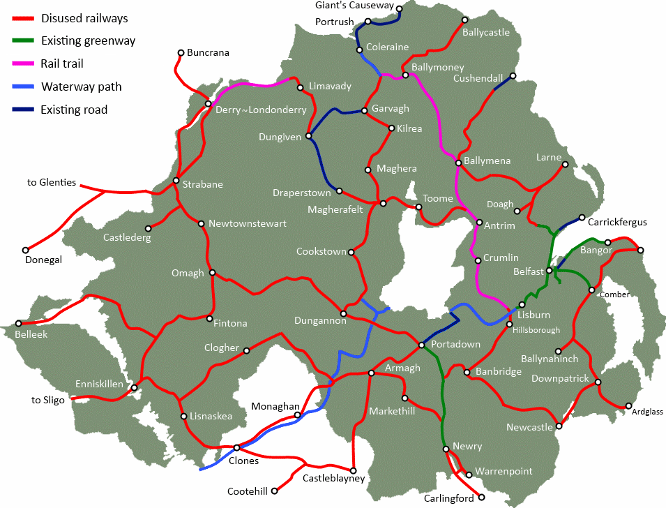
Magherafelt, Draperstown and Desertmartin are linked by the former Draperstown Railway, which shut in 1950. Local communities could benefit from regenerating this route and creating a new Greenway to allow walking and cycling into the County Tyrone countryside. This Greenway proposal is part of a wider network over 600 miles across Northern Ireland which, if realised, could bring activity tourism spend to the Draperstown area.
The Magherafelt to Draperstown Greenway route
The route begins in Magherafelt, which has the potential to be a central hub for Greenways in Northern Ireland. Magherfelt stands at a former railway ‘crossroad’, and there potential to open new Greenway routes to Toome (see: Toome to Magherafelt Greenway), Cookstown and Maghera. The remaining trackbed footprint is visible at the back of the Mid Ulster Hospital, a useful hub for cycle commuting, leisure walking and recuperative exercise.
[googlemaps http://maps.google.co.uk/maps/ms?msa=0&msid=202802535379582075161.0004c004631e60d412f37&hl=en&ie=UTF8&t=p&ll=54.77891,-6.695824&spn=0.069302,0.205994&z=12&output=embed&w=600&h=350]
The route strikes out east through developed agricultural land, with traces of the trackbed almost completely erased at some points. The distance from Magherafelt to Desertmartin is just over 2.5 miles. This would open up easy options for alternative commuting flows, reducing the need for private car travel in the area.
Desertmartin cycling and walking path
The route enters Desertmartin at an existing short off-road pathway. The footprint of the former station is clearly visible at Station Road in Desertmartin. Continuing out into the countryside, agricultural development makes it difficult to follow the old track line. Occasional clues at road crossing, including bridges, remain as markers to the past. The line becomes clearer at a wooded area by the Iniscarn Road, where an impressive road bridge is visible.
[googlemaps http://maps.google.co.uk/maps/ms?msa=0&msid=202802535379582075161.0004c004631e60d412f37&hl=en&ie=UTF8&t=m&layer=c&panoid=Xf9q4cZKhargoaYZmGG-BQ&cbll=54.784364,-6.724076&cbp=13,212.14,,0,7.56&source=embed&ll=54.767375,-6.723976&spn=0.059419,0.205994&z=12&output=svembed&w=600&h=300]
Crossing the Draperstown Road and turning east towards the approach to Draperstown, hedge rows and tree lines are more intact. The 5 mile stretch from Desertmartin to Draperstown ends at the Workspace Business Centre, another interesting Greenway node.
Draperstown cycling tourism
The condition of the route makes this proposal difficult. With agricultural fields reclaiming the land of the former route, difficult choices and negotiation would be required to make a continuous linear path a reality. The benefits of linking the three towns of Magherafelt, Desertmartin and Draperstown could be measured in the health outcomes of encouraging more active lifestyles and travel choices among the local communities. Key links between community and population nodes such as the Mid Ulster Hospital are key to the success of a Greenway project. It is for the local communities, stakeholders and landowners to decide if this vision merits further investigation.
However the potential for building a route includes reinvigorating the local hospitality and leisure sector in the area. If a Northern Ireland network was realised, active travel holidaymakers could be an important addition to the local economy. Developing a further route into the Sperrins, perhaps through the Glenelly Valley to Plumbridge and Strabane, could create a quality tourist route. The Sperrins already boasts a fine outdoor activity network; allowing touring cyclists from home and abroad to reach the heart of the Sperrins through a Greenway path network could help to grow the sector.