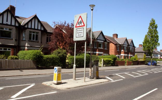
Just five months after the launch of the 25-year Bicycle Strategy for Northern Ireland, work will start next week on the first dedicated cycle routes devised by Minister Michelle McIlveen’s DRD Cycling Unit. The initial sections of a cross-Belfast route and a major overhaul and extension of the infamous Bin Lane are expected to be completed by March 2016, costing up to £800,000.

BBIP

Section 1 will connect three Belfast Bikes stations with a traffic-free protected cycle track, while obliterating the two most famous cycling infrastructure landmarks in Belfast, Cyclesaurus the idiosyncratic dinosaur tail cycle lane and the Bin Lane.

Sections 2 and 3 will create a new bicycle route servicing an area of the city with low cycling uptake. Sections 4 and 5 are due to follow by the end of 2016.

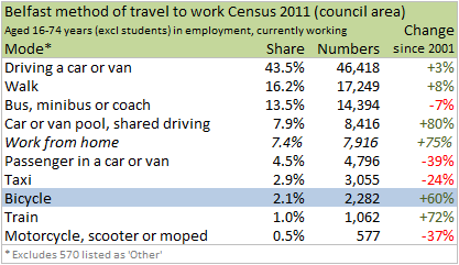
“These routes will provide greater protection for people who choose to make journeys across the city by bike. In addition to supporting the successful Belfast Bike Share Scheme they will also help more commuters gain confidence to use the bicycle as an alternative and sustainable mode of transport. My Department’s most recent figures show that 5% of Belfast commuters are already travelling to and from work by bicycle.”

Minister McIlveen

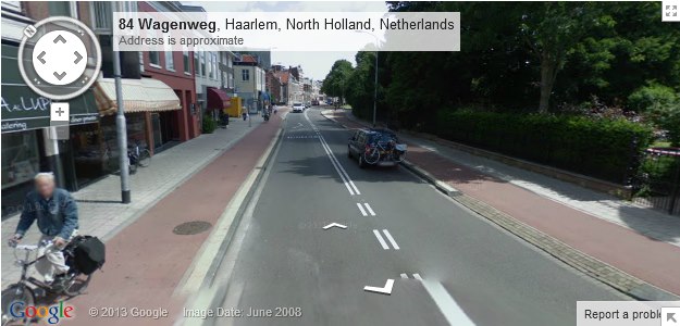
These are officially being treated as pilot routes, giving the Cycling Unit the ability to change elements which aren’t working or need improved. However, the high quality nature of the design shows a determination to set new standards, leaning on best practice from abroad, and the first application of London Cycling Design Standards in Northern Ireland.


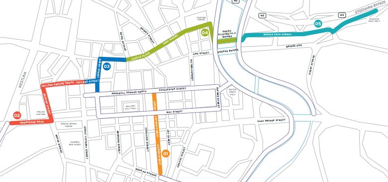
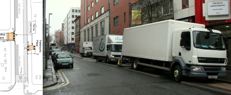
Section 1 – Ormeau Avenue to Chichester Street

Alfred St to be made one-way northbound with a cycleway protected by bollards extending the 0.5km from Chichester St to Ormeau Ave. This will create a 1.1km traffic-free route between NCN Route 9 and the city centre, linking four Belfast Bikes stations and sending a reminder about the need to build the Gasworks Bridge. It will finally obliterate the mess of Cyclesaurus, and reboot the Bin Lane to prevent the daily incursion of delivery vehicles from embarrassing Belfast.

The Ormeau Ave entrance to Alfred St will be made into a continuous footway to prioritise pedestrian and cycling movements.

BBIP1_Ormeau
Redesigned one-way street entrance will feature a continuous footway across the junction

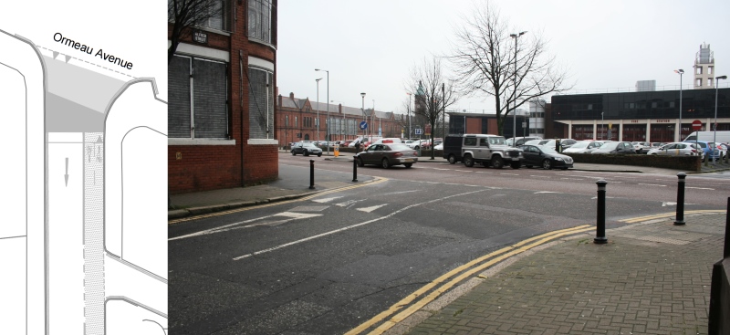
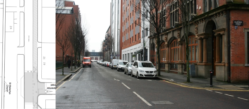
19 on-street parking bays will be removed to provide space for the new cycleway running past the entrance of the Premier Inn Hotel. Will this prove to be one of the more controversial elements of the plan? The popcorn is on standby..

BBIP1_Clarence
19 car parking bays will disappear to accommodate cycling (pinch me)

The junction of Alfred St with Franklin St / Sussex Pl remains the busiest and riskiest junction for cycling on the route. Making Alfred St one-way reduces the total possible vehicle movements on the junction from nine to seven, and with continuous cycle priority across the mouth of Franklin St it may improve safety.

I suspect it won’t be long before Franklin St is stopped up to vehicles here, but that is a battle for another time and another (ongoing) consultation.

BBIP1_Frank
Cyclesaurus – the busiest, riskiest junction still problematic despite Alfred Street becoming one-way

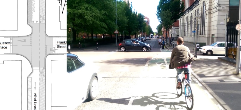
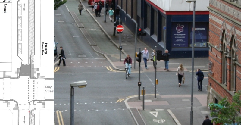
The May St junction will now have a straight-ahead view (removing the traffic pole clutter and cycling slalom effect) with separate crossing for those on bicycles and pedestrians. Vehicles emerging from Alfred St will now be banned from making left turns towards the City Hall. Given the crossing phase is likely to coincide with this green light, it will be most interesting to see if this is observed.

BBIP1_May
A messy junction simplified – straight-ahead cycleway separated from pedestrians and no left turn for vehicles

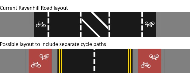
And then to the Bin Lane – why is work necessary to this kerb-separated cycle track? Just take a look at the #BinLane hashtag over on Twitter to find out. The kerb will be removed in favour of a consistent design approach of bollards along the length of the scheme. More controversy (and popcorn) but this time from cycle campaigners? The comments are open..

New loading bays created in place of paid on-street parking on Upper Arthur St (directly below a 472-space multi-storey, for context) will accommodate commercial needs. The intention of bin owners is unclear at this stage.

BBIP1_BinLane
These foolproof kerbs will be replaced by bollards and car parking bays to the left converted to loading-only bays

To misquote The Dark Knight, this protected cycleway is not the plan Alfred St and Belfast’s Linen Quarter deserves, but it is the one it needs right now. With more place-appropriate measures like side street blockages, removal of most on-street parking and cellularisation with area-wide one-way restrictions for motor vehicles, perhaps 90% of circulating and through-traffic could be removed from these streets.

That is the way to humanise the whole area – choked as it is by cars searching for on-street parking spaces – and would make separate space for cycling unnecessary. Any bollard v kerb debate should bear in mind that realistic end goal. But for now, until that plan can be argued for and achieved, mode separation will help to make cycling more attractive.


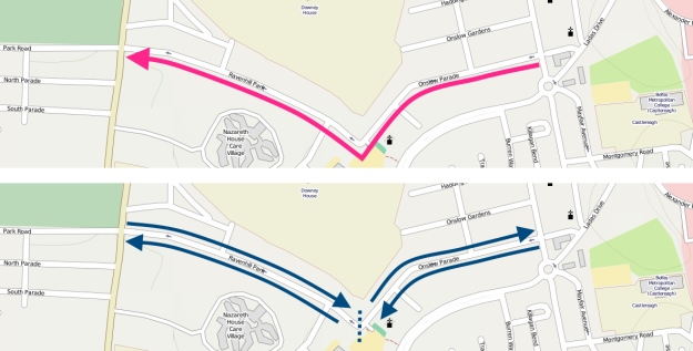
Sections 2 and 3 – Grosvenor Road to City Centre

This represents the first half of the cross-city route which will straddle the city centre from (almost) the Royal Victoria Hospital to Titanic Quarter Railway Station and the greenway network beyond.

Slightly disappointing is the Grosvenor Rd section itself, which will be a shared footway. Once the route is established and seeing regular bicycle traffic (which the expansion of Belfast Bike Hire further up the Grosvenor Rd to the Royal Victoria Hospital guarantees) the Cycling Unit should be given the budget to create a cycleway ramp to Wilson Street. This would significantly cut the journey time and amount of shared used footway on the route, and liven up an otherwise silent street choked with ‘free’ parking.

BBIP_extra

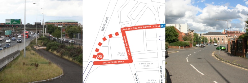
Around the corner to Durham St and the beginning of the protected two-way cycle track, to be built utilising roadspace rather than footway.

BBIP1_Durham
A protected cycle track will be built using road space on this side of Durham Street

The mini roundabout at Barrack St (an earlier measure to reduce rat-running and to humanise these streets) will be replaced by signalled-controlled crossings, flipping bicycle users to a bollard-protected cycle track on the opposite side of the road.

BBIP1_CollegeSq
Two-way cycleway to run on the right hand side (as pictured) of College Square North

At the junction of College Sq N and College Ave, a bold decision has been taken to rework traffic movements to create a bicycle priority junction. A low-level bicycle signal and dedicated crossing phase matching in with traffic turning left out of College Sq N will ensure bicycle users are treated like kings and queens of the road.

BBIP1_College
A dedicated cycle crossing will be placed here, and the right turn seen above will not be permitted

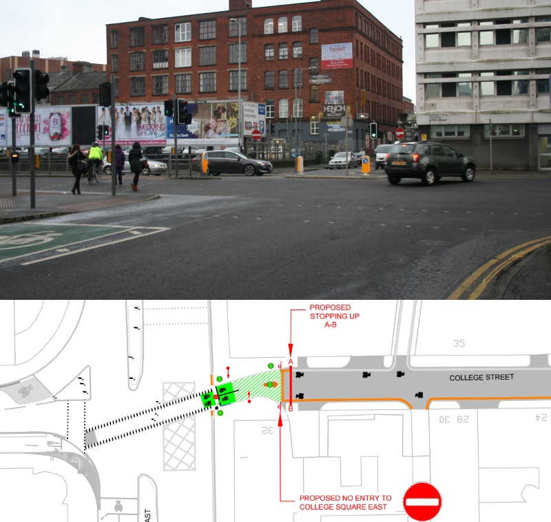
And over on College St, traffic mostly emerging from a surface car park will no longer have that option. The street is to be stopped up to vehicles, becoming  a “bicycle street” with minimal interactions with vehicles expected. This again is radical, should be applauded, and will provide evidence for similar options around the city.

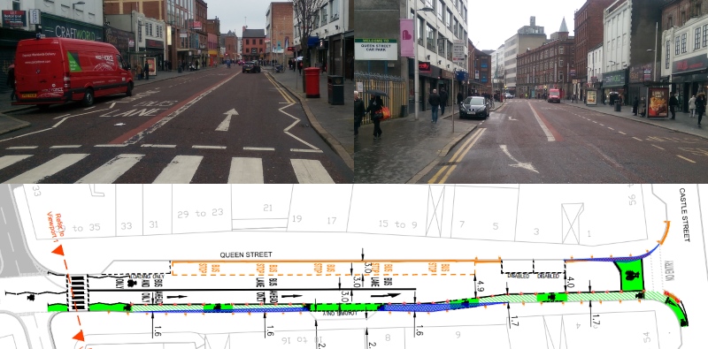
Onto Queen St and there is another bollard-protected cycleway – it may feel like overkill on a street which has seen so much traffic removed over the years, but serves a key purpose as a contra-flow to the one-way system for vehicles.

BBIP1_Queen
Possible conflict point with a shared loading bay / cycleway at the mid point of Queen St will be keenly observed

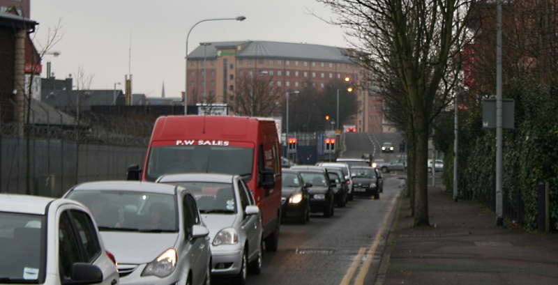
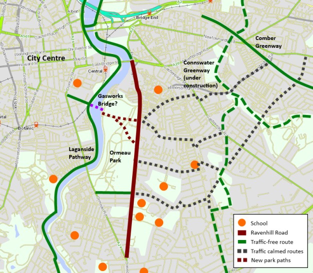
The wider plan is for a traffic-free route all the way from Falls Park, traversing (if possible) Bog Meadows, meeting the cycleway beside the Westlink (and very likely a branch into the new Belfast Transport Hub) then across the city to meet the greenway network which is currently spreading over East Belfast, and the ‘spine’ of Belfast cycling, the traffic-free NCN route 9 from Lisburn to Newtownabbey.


Sections 4 and 5 – High Street to Titanic Station

These last sections are planned to begin sometime in the Autumn and expected to be finished by the end of the year. The High Street section is undergoing a major rework following consultation feedback, but the impressive removal of a lane of traffic on Middlepath St to create a new two-way cycle track will still set a high water mark for cycling development.


The shadow boxing ends – the Cycling Unit is two years old, the Bicycle Strategy for Northern Ireland is now operational and we arrive at the Delivery Phase. Hallelujah!

It is important to set these route announcements in context – the Belfast Bicycle Network Plan and Bicycle Strategy Delivery Plan have yet to be finalised and published by the Cycling Unit. The Minister and her team should be commended for pressing on despite the scant budget at their disposal to date.  If this project signals a Seville-like determination to just get on with building dedicated routes, the future for cycling in Northern Ireland looks bright.

*Note: the section drawing are not the final, final plans but an earlier version available here.

The rise of cycling in Belfast is a welcome sign of public understanding of the flexibility and reliability of the bicycle. But scratch beneath the surface and the classic signs of a poor city environment for cycling are clear. Riding a bike is a non-exclusive activity, open and beneficial to everyone. But Belfast commuter cycling appears to be male-dominated, judging by numbers seen riding each day. What is the reality?

Part one of Socio-economics of Belfast commuter cycling looked at deprivation indicators to trace the economic fault lines in Belfast cycling. The second part Socio-economics of Belfast commuter cycling // Gender gives a quick overview of a shocking imbalance in Belfast.

Gender split in Belfast commuter cycling

Just one out of every six commuter cyclists is female.

Continue reading “Socio-economics of Belfast commuter cycling // Gender”

Belfast is in the middle of a mini active travel boom, mainly driven by rising numbers of bike commuters. But Belfast suffers from structural issues which hold back cycling development, not least the physical barrier of the River Lagan. One plan to provide relief, a new pedestrian and cycling bridge linking the Gasworks site to Ormeau Park, has been largely forgotten. Why?

River Lagan from the Gasworks side

The Gasworks Bridge would span 140m between the Lagan entrance to the Gasworks Site and the Ravenhill Reach car park beside Ormeau Park. The project cost is estimated in the region of £4million to £8million. The benefits to the city have been clear for many years:

  • greater access for people in South and East Belfast to the city centre
  • making Ormeau Park a city centre park, accessible by both residents and workers, 15 minute walk from City Hall
  • provide safer pedestrian and cycling options than Albert Bridge and Ormeau Bridge
  • increase in walking and cycling with the health, leisure and transport benefits
  • further encouraging inner city regeneration with a new signature city gateway

This would be the first standalone bridge to be built in Belfast solely for cycling and walking journeys – an important signal of intention to follow through on active travel promotion. Local residents surveys have always returned positive views, with few concerns about potential interface issues. All very positive, but it seems to have dropped off the agenda.

Why is it important?

The spine of the National Cycle Network runs along the western bank of the River Lagan here, connecting a traffic-free route stretching from Lisburn to Newtownabbey, a developing connection to the Comber Greenway (and the Connswater Greenway project) and hopefully all the way to Bangor in the future. The embankment cycle tracks and shared pathways have contributed to an upsurge in active travel, with cycling flow increases of over 250% observed between 2000-2010 (PDF, 499k).

Gasworks from Ravenhill Reach
View from Ravenhill Reach looking down Gasworks / Ormeau Avenue corridor

Adding the bridge would open up east-west journeys on the National Cycle Network, increasing the potential of the Gasworks Park pathway which links almost directly into the city centre. The Gasworks Park hosts large employers like Lloyds and the Northern Ireland Environment Agency, but also the Radisson SAS Hotel. The bridge would not only be a commuter and lunchtime leisure option, but also a tourist facility.

For walking journeys to work, Shaftesbury and Botanic wards lead the way with over 40% of commuter ‘traffic’ on foot. Yet just across the river there is a sharp drop-off with Woodstock and Ballynafeigh wards around 25% and Ravenhill less than 20%. Physical disconnection is at least partly responsible, with long diversions needed to reach the main employment base in the city centre.

The communities surrounding Ormeau Park are also at the forefront of the the current cycling boom. While still quite low levels compared to proper cycling cities around the world, nonetheless Woodstock, Ravenhill and Ballynafeigh are the top 3 wards in the whole of Northern Ireland by cycling commuter share at 5-6%.

© Crown Copyright Land and Property Services / Spatial NI
Commuter cycling share in wards surrounding Gasworks bridge (Census 2011)

A startling 51% of households in Woodstock have no access to a car or van (Census 2011) over double the rate of Northern Ireland as a whole. Direct traffic-free access into the city centre is both desirable and necessary here.

Belfast has seen a 60% rise in cycling commuters between 2001 and 2011. If a Gasworks Bridge contributed to a doubling of cycling levels in these top 3 wards by 2021, cycling levels would outstrip even bus commuting here, which begins to fundamentally change the inner city transport dynamics.

By upgrading cycling routes beyond Ormeau Park, across traffic-calmed residential streets towards Cregagh and Castlereagh Roads and the two Greenways, a genuine and attractive alternative to car travel becomes possible for a large part of South East Belfast. A positive impact on inner city traffic levels must be considered a key element of the bridge’s benefit.

What are the alternative cycling commuter routes?

The existing connections between the city centre and the suburbs of South and East Belfast have become scenes of cycling commuter stress and conflict. The area is poorly served by just two main access points across the Lagan a mile apart, the Ormeau Bridge and the Albert Bridge.

Side of Albert Bridge Belfast
The Albert Bridge in Belfast, a major barrier to cycling uptake in East Belfast

The Albert Bridge is awful for cycling, with it’s narrow road space, ugly crash barriers and no safe cycle space. Roads Service estimates 50% of cyclists use the narrow footpaths rather than the road. Yet as a listed bridge (built in 1890) the options for change are apparently limited.

Ormeau Bridge Belfast
The Ormeau Bridge in Belfast, possibly the busiest cycling intersection in NI

The Ormeau Bridge has a more open feel, but again has no dedicated cycling space. The ghost bike memorial for Michael Caulfield is a stark reminder of how dangerous our roads are for cycling – more so as the Ormeau bridge and embankment intersection is probably the busiest area in Northern Ireland for commuter cycling.

Why has the project faltered before?

Planners have had their eye on a bridge here for decades, but not always for a footbridge. In the rush to build for a motorised future, 1960s plans foresaw an urban motorway running around the Gasworks site and over to Ravenhill. While the motorway plan thankfully fell away in the 70’s, the idea of a more modest distributor road bridging the Lagan and running to the Ravenhill Road lingered through to the 1990s. Along with the main plan for a southern inner ring road, currently in limbo, this has contributed to urban blight through restricted development along the Bankmore corridor.

© Copyright Albert Bridge and licensed for reuse under Creative Commons Licence
Bankmore Street, effectively abandoned to a road scheme that never happened

Lately with the recognition that a road scheme would not be viable or attractive, and the redeveloped Gasworks site opening in 2001,  the idea of a traffic-free bridge moved up the agenda. Boosted by the inclusion in the Belfast Metropolitan Transport Plan 2015, it seemed obvious that the bridge would be built quickly, given the success of the wider Gasworks and Laganside projects:

“Two new pedestrian/cycle bridge crossings are proposed to serve key activity spines between the east and western sides of the River Lagan. These will improve the connection between the extension of existing riverside walkways and the more strategic sections of the pedestrian network. These bridges will be funded as part of  the regeneration of Belfast.”

Rumblings of trouble can be seen in a Belfast City Council Development Committee report from 2005, when you look at the number of ‘stakeholders’:

  • Laganside Corporation – Gasworks and riverside regeneration
  • Department for Social Development (DSD) – public realm schemes and Laganside Corporation’s sponsor
  • Belfast City Council – owner and operator of land and facilities on both sides of the river
  • Sustrans – the National Cycle Network runs through the middle of the issue
  • Department of Regional Development (DRD) – NI transport planning and infrastructure, including active travel

Lots of interested parties, but no-one to take a clear lead. It was unfortunate timing that the Laganside Corporation was wound up within 2 years of this, having reached £1 billion of investment in the city.

Lagan looking toward the Gasworks Bridge location

The last major push was around 2009, with talk of the project even being linked to the failed national stadium bid at Ormeau Park. An application for Special EU Programmes Body (SEUPB) Peace III funding “fell down on its demonstration of peace and reconciliation outcomes and its ability to provide a lasting legacy to the peace programme”.

If we’re relying on a 140m river crossing to be a transformative factor in community relations and breaking down sectarian divisions, what hope is there for Northern Ireland? EU Peace funding has been practically ruled out, and the reason is clear when you cut through the ‘additional’ benefits and set out the purpose of the bridge in basic terms:

The project’s most important function is to provide a new transport corridor in Belfast.

Therefore it falls squarely within the remit of DRD and their executive agency Roads Service. A Belfast City Council Development Committee report on the potential construction and maintenance of the bridge from back in 2005 shines a troublesome light on DRD active transport thinking:

“It is obvious that responsibility for the project should be taken up by Roads Service. Initial contact with Roads Service has however been met with a lukewarm response despite the rhetoric in the BMTP etc in regard to walking and cycling as valid means of transport.”

Can DRD to demonstrate they have moved beyond this point, and take ownership of a major project exclusively for active travel? Is there a golden window of opportunity given the ongoing difficulties with the A5 road project?

What is the way forward?

The recently opened Peace Bridge in Derry~Londonderry is a fantastic local example of what can be achieved for urban cycling and walking transport. Around 2,300 people use the bridge every day, and is a challenge to Belfast to replicate or exceed this impressive performance.

PeaceBridge1
The Peace Bridge in Derry~Londonderry

For an international comparison, Copenhagen is one of the leading cities in the world for urban cycling, with a journey share of around 36%. But it’s a city still trying striving to improve, and leading this charge with urban bridge building for non-motorised traffic with the Copenhagen harbour bridges project.

Gemini Residence 3
Bryggebroen cycling and pedestrian bridge in Copenhagen

The Gasworks Bridge is a key element of re-imagining and reworking central Belfast. Council plans are afoot for sweeping regeneration from the Markets area to Sandy Row and Shaftesbury Square. The bridge would open up new possibilities for commuting, leisure, shopping and social trips that aren’t really viable today. It’s easy to overplay the significance, but the bridge even has the potential to help boost the evening economy in the city.

The Gasworks Bridge is a key part of the Belfast Metropolitan Transport Plan 2015, which is still used to determine capital project priority in the current budget period. If the DRD Minister should wish to leave a legacy for Belfast which provides positive encouragement to reduce car journeys, he would struggle to find a better opportunity than the Gasworks Bridge.
.
[youtube http://www.youtube.com/watch?v=GtjBjgHkAAM?rel=0]

What do you think about the idea of a Gasworks Bridge? Will it encourage you to ditch the car? Comments are open below..

*** UPDATE *** 20th June 2013 *** UPDATE ***

A week is a long time in politics, and one week on from this post there is stunning news. Regional Development Minister Danny Kennedy, while addressing the Politically Painless Active Travel conference in Belfast, announced he is to commission a feasibility study into the Gasworks Bridge project!

Danny Kennedy Gasworks Bridge

This is great news for the local community, active travel organisations, councillors and many others who have put in the real work over a decade to see this bridge built. Hopefully DRD / Roads Service will make swift progress, and the project’s overwhelming benefits will ensure a positive outcome. The potential to transform this part of Belfast is immense – with Belfast cycling on the rise, it seems the Gasworks Bridge’s time has come!

With the Gasworks Bridge back on the agenda for Belfast, regular cycling may become a serious transport option for many people in southeast Belfast. Yet the current barriers to cycling must be overcome to extract maximum benefit for the people of Belfast. The Ravenhill Road may become the focal point to set a new Belfast standard for designing roads for people, not vehicles. By looking at best practice from the Netherlands, a simple plan can be set out to revolutionise the experience of cycling in Belfast, and provide the backbone for a new high density active travel network.

Ravenhill1
Ravenhill Road layout at Cherryvale Park entrance, central island dominates the road

Ravenhill is a ‘B’ road which suffers from being the most direct route between the northern and southern sections of Belfast’s ring road. Yet it’s also a narrow, leafy residential road, with two major parks, large schools and a handful of locally-focused businesses – a quiet backwater in contrast to the bustling parallel Ormeau and Cregagh Roads.

It also runs through the highest density of cycling commuters in Northern Ireland, with around 5% of residents from Ormeau to Cregagh choosing to regularly bike to work. Yet there is little evidence of a wider cycling culture here outside of the typical commuter profile. The current advisory cycle lanes send out the message that cycling is for commuters only, and contributes to the unhealthy gender profile of Belfast cyclists.

To open up journeys to everyone – young and old, men and women, families, shopping trips, leisure rides, all day and night – needs a tried and tested simple solution, dutch-style separation. If your instinct says this is too radical for Belfast, you might be surprised to know an example of high quality separation is just 200 metres away.

RavenhillOverview

Planning for the Ravenhill Road to become an important link in many journeys between suburbs and centre, and between parallel greenways, requires 3 simple steps.

Separation

Whether through lack of funding, commitment or vision, Belfast’s cycle network has been allowed to develop as a series of disjointed on-road lanes. Worse still, they are designed around the needs of motor traffic – exceptional at keeping cyclists out of the way of cars, vans and trucks in higher speed sections where conflict isn’t necessarily an issue, and removed when cyclists’ needs are greatest, at junctions and roundabouts.

OrmeauRoundabout

Predictably the cycle lanes disappear at the approach to the Ormeau Road roundabout. Less forgivable is the disappearance at the other end of the Ravenhill Road, solely to cater for traffic using a major city rat run at My Lady’s Road (see video).

The issues with advisory cycle lanes in Belfast are well known to readers of this blog, and the Ravenhill Road has featured on the Reclaim Belfast’s Cycle Lanes two surveys. Each side of the road has an urban clearway for 1.5 hours each weekday, which means for 96% of the week parking is perfectly legal; these spaces cannot truthfully be described as “cycle lanes”.

The following video shows how the quiet adjacent Park Road has a high quality separate lane, while the busier Ravenhill Road has much poorer facilities in comparison.

Paint on the road will not encourage parents to let children ride to school alone, parents to take small kids to nursery on bikes, those too afraid to cycle into the city centre to work, or for short trips to the shops. This approach has delivered little more than 2% of traffic on bikes across Belfast. It’s time to take a bold step –  redesign a major road with fully separate cycling infrastructure.

Redesigning Ravenhill Road

The current road layout is quite standard for Belfast, with:

  • a fairly consistent 16.5m span
  • roomy footpaths
  • on-road advisory cycle lanes
  • 2 traffic running lanes
  • a central island lane running almost the full length to aide turning movements

RavenhillLayout

Taking inspiration from Haarlem in the Netherlands, a reworked configuration would see the central island lane removed. Two running lanes are retained at approximately 3 metres each way, with 2 metre footpaths and 2 metre cycle tracks with a standard 0.5 metre kerb separation from the carriageway.

Separation benefits cyclist not just through actual safety and the perception of safety, but also removes limitations of being part of traffic. Short side road to side road trips are possible on a two-way cycle track on either side of the road, allowing many children to cycle to school without having to cross a road to join traffic.

Haarlem
Balanced roadspace allocation in Haarlem on similar road footprint

What about the tough places where the cycle lanes disappear? Again the Netherlands have decades of experience when it comes to junction design. The Ormeau Road roundabout may be jealously guarded by road engineers, but the Park Road/Ravenhill Park junction is ripe for a Dutch-style experiment, and the Ormeau Embankment junction could benefit from a southbound pass-through lane and better separation on the other approaches.

[youtube=http://www.youtube.com/watch?v=FlApbxLz6pA&w=640&h=360]

Traffic calming

Ravenhill Road

The loss of right hand turning boxes may be the most controversial suggestion, but consider how Roads Service balance the needs of all roads users with this central island. Running between Ravenhill Avenue and Rosetta Park (1.8km) there are 22 turning spaces for vehicles, compared to just 7 pedestrian crossings, and only two of those give pedestrian priority (pelican crossings). Vehicle needs and safety trumping those of vulnerable road users.

RavenhillCrossing

For the majority of desire lines (at more than 20 side roads and paths) there is no direct crossing, so people are forced to wait for a break in the traffic to cross, or make a long diversion.

Creating a series of zebra crossings on the redesigned road to cater for more pedestrians and cyclist crossing is essential. The needs of through-traffic from the south of Belfast and beyond to the city centre must be placed second to the needs of local users, especially those walking or cycling the school run.

In rural areas the right hand turning box is primarily a safety feature. In a 30mph urban/residential road it is there to enable the efficient flow of traffic around turning cars. It’s time to consider whether high average traffic speed should be the goal of urban road design, especially if it suppresses other transport needs and more liveable streets.

Side streets

The success of cycling in the Netherlands isn’t solely about separation. There is the understanding and empathy fostered by virtually the entire population cycling, and sustainable safety principles governing all aspects of design, not least at junctions and side roads.

Looking at the example below, cycle tracks and footpaths continue across side roads, giving priority to the more vulnerable users, but also a strong visual cue that you’re entering a different classification of road, and the sense of needing to adjust speed.

HaarlemExample
How side road access could be reworked on Ravenhill and pedestrian crossing example

You might think road regulations won’t allow for such a design in Northern Ireland; you may not be right.

The rat run at My Lady’s Road is a blog post in itself for another time, and London Road and Ravenhill Avenue don’t suffer from particularly heavy traffic flows – traditional calming methods could be easily deployed to discourage through-traffic.

Conall McDevitt’s 20mph Bill will be debated in the Assembly in the Autumn, and is understood not to be supported by the Department for Regional Development. Blanket 20mph limits on the residential streets here would be a great boost to active travel.

Ravenhill Park

To develop a high quality east-west cycling corridor with Ravenhill Road as the axis requires one major piece of road management. Linking the Connswater Greenway at Cregagh to the Ormeau Park and Lagan Towpath is possible by creating a traffic-calmed route along Ravenhill Park.

At the moment Ravenhill Park is one-way going west, which makes it a fast popular rat run route for traffic trying to reach the Ormeau Road from East Belfast. It’s also an unnecessary barrier to eastbound cycling journeys using the Park Road cycle lane – even (illegal) footpath cycling against the traffic isn’t possible due to high kerbs.

A simple, if radical, solution would be making Ravenhill Park and Onslow Parade 2-way again, but placing a barrier to vehicles beside Ravenhill Rugby Ground – removing all through traffic, calming speeds to solely residential users, and opening a new cycling corridor. Retractable bollards would be an ideal solution to allow fully flexible traffic management for Ulster Rugby matches and events at the new Ravenhill Rugby Ground. The Onslow side has a natural cul-de-sac turning circle at the stadium, and the nearby Ravenhill Park Gardens junction could provide a similar function on the park side.

Ravenhill Park Small

Eastbound rat run traffic is unlikely to divert to Ardenlee Avenue, reverting to the more suitable Mount Merrion corridor. Westbound traffic wishing to use Park Road and Ardenlee as a cut-through from Ormeau to Cregagh can be discouraged by the lack of right turning boxes, changing the design of Ardenlee to a more residential style with raised entrances and cycle track priority, and further traffic calming.

Ormeau Park cycleways

Ormeau Park actually creates a minor barrier to the success of the future Gasworks Bridge. To be a truly transformative active transport corridor, new cycleways across the park, with lighting for the winter months, would be needed to for the most efficient journeys.

The lack of a bridge over the Lagan means there are no direct ‘desire line’ paths going east-west across the park. The ‘cage gate’ entrances designed to discourage cycling and prevent motorcycles accessing the park must be replaced with a better solution.

[youtube=http://www.youtube.com/watch?v=hZEum3RpJ8I&w=640&h=360]

Belfast City Council’s parks opening hours (7.30am in the morning until sunset, as early as 5pm in the winter) would also cut into a large portion of homeward ‘rush hour’ and the potential to drive citybound evening economy journeys. Diverting people around the park would make the corridor and cycling less attractive. Ormeau Park would need a new 6am to midnight year-round policy.

Re-imagine Belfast and demand better

The potential Gasworks Bridge opens a range of possibilities and the chance for new thinking on how to move people around Belfast. Our streets are dominated by vehicles, but this is as much down to road design as to personal preference. Ideas and discussion are important to changing mindsets and building the space for active travel. In a city with rising congestion, falling car ownership, troubling levels of obesity and a more dangerous environment for cycling, tacking little bits of advisory cycle lane onto intimidating roads is no longer an acceptable waste use of public money.

Northern Ireland must learn from and implement best practice from the Netherlands for how to develop the safest and most attractive cycling space. This is how London is approaching its cycling vision, and Belfast realistically has an opportunity to lead the United Kingdom in cycling uptake, given the natural advantages for cycling. Belfast Bike Hire, the Giro D’Italia, rising commuter levels, the Gasworks Bridge – the stars are aligning for something truly special to happen in our city.

Give the people safe space to cycle and they will choose to do so in droves. Continue to pretend that Belfast’s roads are fit to promote as an genuine active travel option and we will all lose.

The North Down Coastal Path, and the surrounding local economy, is one major project away from fulfilling its tourism and leisure potential. A new high quality traffic-free link is needed to address the current disconnection from Belfast. This will integrate with the growing urban greenway network, encourage Belfast residents to visit North Down more regularly, and open up a new seam of tourism opportunities. Considering the current options for route development, an intriguing new greenway project is proposed.

Explore the Belfast urban greenways on Google Maps
Traffic-free network in Greater Belfast Area – disconnected from the North Down Coastal Path

.
The North Down Coastal Path begins at the north end of the George Best Belfast City Airport runway, with a gate to the road running past the Kinnegar Army base. From here, Belfast City Hall is 6.5km away with no direct traffic-free route. When the Connswater Community Greenway is completed as far as Victoria Park the shortest distance to this pathway network will be 4.5km, but accessible only by busy main roads.

This is a particular problem for leisure cycling; families with youngsters, inexperienced cyclists, tourists based in Belfast. These are already significant distances before the relaxed ‘leisure’ part begins, and poses a barrier to many people who would otherwise love to tootle along the coast for a day and spend in the local economy.

At present there are just two options available for travelling by road. Both routes are quite direct, but also have severe drawbacks for cycling and walking.

The A2 / Sydenham Bypass

The road ‘benefits’ from separate cycle tracks on both carriageways, but you’ll seldom see people choosing to take this route. This is quite a horrible place to be on a bicycle; a heavy traffic urban dual carriageway, with vehicles travelling above and below the 50mph speed limit.

An apparent lack of sweeping leaves the cycling surface strewn with road grit and glass. Not a happy start or end to a leisure trip, and not somewhere suitable for children or inexperienced riders to cycle. Great if you like cinematic thrills, but not fit for purpose as a modern cycle route.

Sydenham Bypass cycle lane, murderous traffic, puncture-friendly surface

It’s hard to imagine a country like the Netherlands, where road design is based on sustainable safety principles, funnelling cyclists into the hard shoulder of what is practically an urban motorway, then promoting it as an important link in the country’s cycle network.

Pedestrian access to the bypass is slightly easier with the footbridge at Sydenham Station and subway by Victoria Park, but the drawbacks of the traffic noise and fumes make this a less than appealing environment. Popular with joggers and power walkers, but lacking in great utility.

Future development of the road will include widening to three lanes each way. There will be just one 3.5m shared cycle/footway on the Victoria Park/Airport side – finally to include a physical barrier which should improve safety perception – but designing a mixed footpath on this fast cycling commuter route is a real backward step.

As the Sydenham Bypass reaches the Tillysburn Gyratory, it’ll be back to the current heady mix of footpaths, hard shoulders and crossing over fast slip roads. With no cycle lane up the slip road to Holywood Exchange, cyclists are encouraged to continue for another 2.6km on the dual carriageway into Holywood town, missing the first section of coastal path.

While it’s important to retain cycling and walking space in major road developments, this appears to be an ideal time to seek better accommodation for sustainable journeys on this corridor.

The Airport Road

Favoured by many cyclists at present, the Airport Road tracks the western side of George Best Belfast City Airport. By comparison with the Sydenham Bypass, the traffic flows are greatly reduced. Yet heavy goods vehicles and oil tankers dominate the road here, and again this poses a frightening dilemma for the novice cyclist. The pathways suffer from high kerbs and no dropped access at the many side roads; unsuitable for cycling, so the road is the only option at present.

There are plenty of opportunities on the countrybound side to reclaim space to develop a separate cycle track with the parallel pedestrian pavement. This is understood to be the preferred solution for a future cycling route, with a new bridge due to link Victoria Park with the Airport Road at the end of the Connswater Community Greenway.

Airport Road Belfast

Yet there is another issue which makes this route currently unattractive – the isolation. There is one way in and one way out, with some limited added value with the commuting link to the Bombardier site and businesses based in the Heron Road Complex. But workers here will tell you the dirt left by heavy construction traffic makes cycle commuting conditions less than ideal.

The Airport Road option also narrows the usefulness of the route to cyclists only. Very few ‘additional’ walking journeys would be generated along this stretch, being set so far away from residential areas.

But is there another way to accommodate sustainable transport in this part of the city, and link the greenway networks, away from the compromises of being tied to major roads?

A Sydenham Community Greenway?

Looking to the southeast side of the airport, across the A2 and railway line, there is another option worth exploring which ticks many more boxes:

  • direct route
  • traffic-free
  • space for full mode separation where needed
  • integration with rail network
  • greater number of access points
  • weaving through residential communities
  • integration with existing leisure facilities
  • new commuting and shopping access

Sydenham Community Greenway proposal section 1

Starting from the Connswater Community Greenway link to Victoria Park, this route would make use of Inverary Drive. This traffic-calmed and relaxed residential road is an ideal start, running for almost a full kilometre. There is an existing bridging pathway between Park Road and Inverary Drive which can be upgraded to greenway standard.

Inverary Drive pathway

Inverary Drive is a wide and calm street environment with very little through traffic. It’s possible to accomodate cycling on the road (with a 20mph limit) but space exists to provide a fully separate track by the railway fence for a ‘continuous’ route feel, and providing the highest safety standard to separate pedestrians, cyclists and other vehicles for this short stretch.

Inverary Drive

There is an important link with Sydenham railway station on this route, and a greenway route on the doorstep opens this station up as a jumping off point for journeys towards the Connswater/Comber corridor, and north where we’re headed.

Continuing on, the road turns east into Inverary Avenue at the Inverary Community Centre, but this proposal would run a traffic-free path behind the centre and through Alderman Tommy Patton Memorial Park. This popular urban park has recently upgraded its play facilities, and is another lesser-known gem in Belfast. Passing by the football pitches, the new path would approach a patch of woodland. There is an existing looped forest pathway which runs along the boundary with the train line; this could be carefully and respectfully upgraded for the purposes of a continuous greenway route.

Alderman Tommy Patton Memorial Park woodland path

Viewed from the woodland path, the potential local benefits of the next section start to snowball – the main terminal of George Best Belfast City Airport is but a stone’s throw away. The greenway would continue to follow the line of the railway fence, across the back of Shorts Recreation Club and Blanchflower Park.

George Best Belfast City Airport

As with Alderman Tommy Patton Memorial Park, there appears to be ample space to set the railway fence back closer to the line if it’s necessary to accommodate the path away from the existing parks. But for the whole route to be viable, one piece of major engineering is needed at this point.

SydBridge
A very poor artist’s impression of a standalone bridge

The most direct route to Holywood requires the path to cross over the railway lines opposite the airport. There are two options here:

  • a standalone bridge crossing diagonally to meet the airport exit road
  • a looped ‘S’ bend crossing over the railway tunnel at the Sydenham Bypass and turning again into the airport exit tunnel

George Best Belfast City Airport Access Underpass

A simple upgrade of the airport access tunnel can continue the route towards Holywood Exchange. The tunnel already has a wide footpath and cycle lane marked on the road. Providing kerb separation at the exiting cycle line would allow 2-way cycling and walking without affecting airport traffic. There is a further option to drop an access path from the countrybound Sydenham Bypass, allowing direct cycling and walking access from the Tillysburn cycling underpass and linking the communities around Knocknagoney Park.

Sydenham Community Greenway proposal section 2

The City Airport site employees around 1,500 people, with many workers travelling from East Belfast with little option but to drive. This new greenway option opens up a significant swathe of Belfast to a truly viable alternative to car travel. And if you think the suggestion of cycling to an airport for onward travel is daft, this isn’t the case at other airports around the world, even including many served by George Best Belfast City Airport flights.

Holywood Exchange abandoned access road behind IKEA

The roundabout at the airport tunnel leads off to an abandoned access road. Today this is used for fly tipping and is a favourite spot for taxis wanting to beat the waiting restrictions within the airport car parks. This is ripe for conversion to a walking and cycling-only route into the Harbour Estate at Holywood Exchange as part of the greenway. The proposed path would cut left alongside the airport boundary fence and into the retail complex at IKEA’s massive sign. There is already a natural land buffer between the airport boundary fence and Airport Road West, ripe for a separate cycle track all the way to the North Down Coastal Path.

IKEA sign at the George Best Belfast City Airport boundary fence

Hundreds more local workers travel to the large businesses situated here: IKEA, Decathlon, B&Q, Sainsburys, Next, BHS, Harvey Norman. Commuting options are increased for locals, but also new options for shopping trips..

Cough cough .. stop right there! Shopping at IKEA? By bike?!

If the idea of cycling to IKEA to go shopping seems even more daft than the airport link, it’s perfectly obvious, natural and not uncommon in other countries. The difference between a city like Copenhagen and Belfast is exactly the type of traffic-free infrastructure being proposed here.

geograph-1274238-by-Rossographer

The separate cycle pathway would continue along the airport boundary fence until passing out of the Holywood Exchange complex, before turning under the flight path at the end of the runway. This is another one of those little treasures of Belfast – standing under a landing aircraft seemingly at touching distance.

Getting from the airport side to the Kinnegar gates requires a road crossing – the only one on this entire 4km route. The bulk of traffic on the road only goes as far as the retail park, so a pelican crossing  beyond B&Q could be an appropriate solution. Once the confusing access issues with the Habour Tillysburn gates are ironed out, a continuous link to the North Down Coastal Path is now achieved.

Local value of a long-distance greenway

Running the connecting greenway through a residential community rather than the Airport Road must be carefully weighed. The main local benefit would be the potential displacement of some regular private car journeys to cycling and walking.

The 3 wards surrounding this proposed route, Sydenham, Island and Belmont, have just over 16,000 residents. Census figures bear out that these ‘greenway wards’ are not much different from the rest of Belfast; just shy of a quarter of all commuting journeys are under 2km (1.2 miles) and nearly two thirds within 5km (3 miles) range. Yet motorised trips are higher here at 56% (48% all Belfast) and walking journeys lower at 17% (22% all Belfast). One third of households in the greenway wards have no access to a car, which is a high figure in itself, but less than the Belfast average (40%), so the area is possibly more car dependant that it needs to be.

Alderman Tommy Patton Memorial Park entrance path
Alderman Tommy Patton Memorial Park linking greenway trips to Ashfield High Schools?

While the footprint of the proposed greenway is on the periphery of the residential area in these wards, it would still open up new linkages into the harbour estate and enhanced traffic-free sections for many parents and children on the school run to Victoria Park Primary School, Ashfield High Schools and Sandbrook Nursery School.

A potential new community greenway for Belfast, linking the city with the North Down Coastal Path, providing viable commuting, shopping and leisure alternatives to private car travel. On the face of it would seem a very cost-effective option should Belfast City Council, Northern Ireland Government departments, Sustrans or others wish to take it forward with a feasibility study. With just a few wrinkles to be ironed out on access, this would seem to provide excellent value for money – a 4km Sydenham Community Greenway as the final piece of a fully connected Belfast Metropolitan Area greenway network. Is it possible?

The green cycle box is arguably the most high profile cycling investment in Northern Ireland in the last decade. Roads Service have mercilessly slathered green paint over junctions across the province, in one of many half-hearted attempts to convince people to get cycling on our roads.

I cycle across 6 advanced stop lines (to give them their official title) every day, and I struggle to see the benefit. Their presence encourages some uniquely difficult road manoeuvres, if not actually putting cyclists at greater risk on some parts of our roads. This is bad enough, but when it turns it that vehicles are blocking cycle boxes at 58% of red lights in rush hour it’s time to ask some serious questions.

St George's Market - blocked just 25% of the time, but difficult to reach safely

Gathering evidence

Two years ago I got a mini video camera, which had a handy bike attachment. I started to take it out  in 2012 to show some of the dangerous aspects of Belfast cycling. I’ve posted a few videos of dangerous overtaking moves, Maseratis hogging the cycle lane and to demonstrate the problem of illegally parked cars rendering Belfast’s cycle lanes useless.

By forgetting to delete these files as I went, I accidently ended up with a large dataset ready for a personal mini survey of cycling around Belfast!

Albert Bridge - one complete block and another partial block to the far right

My main commuting journey involves 3 cycle boxes in the morning:

  • John Long’s Corner (2 lanes)
  • St George’s Market at East Bridge Street (3 lanes)
  • Cromac Street pedestrian crossing (3 lanes)

and another 3 in the evening:

  • Hamilton Street exit Cromac Square (3 lanes)
  • Albert Bridge (5 lanes)
  • The Mount (3 lanes)

© OpenStreetMap contributors

Reviewing footage from September 2012 to February 2013, I collected key data on cycle boxes from 185 mainly morning and evening rush hour journeys, on:

  • whether the light was red
  • if vehicles were present
  • if the cycle box was blocked by another vehicle (partially or completely)
  • if the junction was blocked on green

For balance, I also checked for the biggest problem on our roads, red light jumping cyclists.

Albert Bridge cycle boxes are blocked 56% of the time - where do I go here?

During these journeys I encountered 625 cycle boxes. Just 370 had a red light, meaning I’m caught at these junctions 59% of the time.

Discarding 44 red lights (12%) where I didn’t reach (nor have sight of) the cycle box leaves a group of 326 occasions where I could judge interactions with other vehicles.

Blocked cycle boxes

138 cycle boxes were empty, but a whopping 188 cycle boxes had at least one blocking vehicle. That’s a blockage 58% of the time. These blocks involved a total of 285 vehicles, or typically 1.5 vehicles on every blocked cycle box. Just over a third of all blockages involved 2 or more vehicles.

What counted as a blockage? A partial block is where a car had rolled over the stop line (car in the picture below), and a complete block was leaving no room for a cyclist to stop in the cycle box (motorcycle in the picture below). Of all the blocked cycle boxes, the split was:

  • one or more vehicles partially covering the cycle box – 84
  • one or more completely blocking the cycle box – 70
  • a mix of both partial and complete blockages – 34

Hamilton Street exit suffers from regularly blocked junction and cycle box (59%)

Each junction with a cycle box has different characteristics, but the stand-out junction for blocking is countrybound at The Mount (video below). This is a 3 lane junction with the outside right lane split to turn onto Castlereagh Street. The 2 ‘straight-on’ lanes benefit from cycle lane access all the way to the junction, but it’s useless for turning right.

Of 88 red lights I stopped at, 75 had at least one vehicle blocking the cycle box – the junction suffers from at least one blocking vehicle at 85% of red lights in rush hour. Added to this, cyclists filtering across 2 lanes to reach the split lane find an incredibly dangerous mix of a light which can’t be timed and a tight gap between traffic islands.

[youtube http://www.youtube.com/watch?v=DJui_rxg85Q]

Cycle boxes (on this particular route) are not providing safe space for cyclists. Knowing your odds of getting comfortably and safely into dedicated cycle space is less than 50/50 means they are practically useless.

Not all vehicles sitting on a cycle box have done it intentionally – many drivers will rightly stop on amber rather than try to speed through the junction, and this may mean coming to a safe halt beyond the first stop line. However the sheer levels of blockages recorded indicates more is at work than just being caught out by light phases.

Whether there is a design solution to this, or it’s all down to driver education is up for debate. But there is that pesky question of enforcement..

What are the police doing to tackle cycle box blocking?

It appears not a lot. An FOI request from last year shows that the PSNI do not differentiate between categories of stop lines offences:

“The offence of breaching an advanced stop line is not differentiated from breach of a normal stop line (at a set of traffic lights) in police issued fixed penalties. Therefore there is no way to determine what manner of breach has occurred.”

This is despite a clear difference in the intent of a stop line with a cycle box (to provide safe space for cyclists) and the effect that offences committed here have on road safety. This is a clear failure, and must be addressed by local politicians. If there’s no evidence of enforcement, it’s fair to suggest there is no enforcement.

Red light jumping cyclists

I shared a red light cycle box with 102 other cyclists. There were 33 recorded instances of rule breaking, although 8 of these were directly caused by vehicles blocking the cycle box, forcing cyclists to advance ahead of the second stop line (picture below).

Cyclist forced to position himself ahead of cycle box by blocking vehicles

What was the nature of the rule breaking? 20 cyclists positioned themselves slightly ahead of the cycle box (picture below),  which gets more dangerous if you continue to edge forward. Pavement cycling was recorded on 4 occasions, but just 1 true ‘red light jumping’ cyclist was recorded, continuing across The Mount junction while the pedestrian crossing lights were green. For the record then (small sample it may be) that’s less than 1% of cyclists observed jumping a red light on these journeys.

Crossed line is a crossed line - majority of rule breaking involves sitting ahead of the cycle box

Blocked junctions

Reviewing these junctions led to another clear conclusion, apparently resisted by Roads Service as unnecessary – Cromac Square needs a yellow box junction. Of all the 370 red light cycle box encounters where I could observe the junction ahead, the way was blocked on green 35 times. Not bad, until you realise 27 blockages occurred at the Hamilton Street Exit at Cromac Square. That’s a wildly inefficient junction with 40% blockage rate at rush hour – time to get the paint bucket out Roads Service!

Buses from East Bridge Street blocking Cromac Square in the evening rush hour

Cycle boxes that are dangerous to reach

The 6 boxes highlighted in this survey have very different characteristics. Just 2 have a cycle lane which protects a separate route for cyclists to reach the box, Hamilton Street Exit and The Mount (for straight-on cycling only). The others leave cyclists to filter through sitting traffic, with little physical space to do so, and perhaps most dangerous from a road safety design perspective, no idea if the light ahead will change before you reach the box.

By far the worst cycle box for this is St George’s Market on East Bridge Street. A with-flow bus and cycle lane (which successfully excludes taxis) leads over the train bridge, followed by a bus gate (not triggered by cyclists) and then a short run to the junction with Oxford Street, notorious for vehicles quickly and sometimes recklessly changing lanes. In sitting traffic, it is virtually impossible to time the lights at the junction. With no separate cycle lane leading up to the cycle box (as with the Hamilton Street Exit), cyclists have a difficult choice – chance filtering down between traffic, or sit back and lose the benefit of the cycle box.

Should I stay or should I go?

The numbers bear this out, even for an experienced cyclist like me – at 42 red lights I only made it to the cycle box on 22 occasions (52%). Twice I stopped short of the box as it wasn’t worth passing 1 or 2 cars, but 18 times (43%) I was unable to judge the lights and so stayed back in the traffic queue.

Recent census figures showed the concentration of commuter cyclists in South and East Belfast. This means the 2 major cycling gateways to the city are Ormeau Bridge and Albert Bridge (and by extension East Bridge Street) and this is a heavily used junction for cyclists. If nothing else, this mini survey shows attention is needed to provide better and safer access to this cycle box in rush hour.

Finally “the worst drivers are..”

Grumbling motorists cite red light jumping cyclists as a menace; grumbling cyclists cite flashy car drivers or taxis as major dangers. Everyone seems to have a clichéd grudge against someone on the roads.

So let’s not labour the point, but here’s a breakdown of the types of vehicles (out of 240 identified marques) which blocked these cycle boxes, by car make and vehicle category – and what percentage of each are actually on the roads in NI. It’s a small sample with plenty of variables, so it’s just for fun – make of it what you will!

Those 'professional drivers' of taxis showing their road knowledge once again

Belfast, my home town,  remains a very divided city in many ways – you just need to look at the recent ‘flag’ unrest for a quick snapshot of some key fault lines.  Riding a bike doesn’t strike me as a particularly divisive activity – in fact it seems like a liberating, egalitarian way of travelling. The Dutch Cycling Embassy would say that in the Netherlands, people at all levels of society and income use the bicycle – “young or old, rich or poor, everyone cycles” – and why would it be any different in Belfast, even with tiny numbers by comparison? But are we overlooking some important details in the bigger picture?

TravelwiseLagansideVH8O4283

In a city where commuter cycling modal share is only between 2.1% and 4% in 2011, and where the physical environment and perceived danger actively discourages people from cycling for transport, is bicycle ownership purely a luxury? Is there some truth to the suggestion that unhealthy city environments shape the urban cyclist population to be unnaturally male and middle class?

Detailed ward-level figures from the 2011 Census allows us to delve deeper into the mysteries of commuting choices in Belfast. Does the reality destroy such myths, or has the domination of the private motorist, and a city environment unsuitable for mass cycling, left key sections of our society behind? Part 1 of Socio-economics of Belfast commuter cycling, a short series of blog posts being released over 2013, looks at how cycling as a form of transport is unevenly distributed across Belfast.

Cycling across the class divide?

First to set the scene for those who don’t know, Belfast is a relatively small city, with low population density and a highly centralised employment and retail core. The city’s development, heavily affected by The Troubles, has left fractured communities sharply divided by religious background and class – although lines have begun to blur over the last 20 years. Leafy affluent suburbs mix with deprived inner city areas, more concentrated in the central core, west and north.

Crash course on the Belfast labour market

The five central wards with more than 10,000 employee jobs (Shaftesbury, Duncairn, Falls, Botanic, Island) account for 59% of employment in the city (map 1) with the only major employment centre outside the central spine being the Stormont area to the outer east, site of many government department offices. The labour market is split between approximately 55% of workers travelling in from outside the city, and 45% who live within Belfast. But 75% of employed Belfast residents work within the city council area, so the internal labour market seems quite inwardly focused.

JobsMDMBelfastWards6

To look at how the population is distributed across the city, the Northern Ireland Multiple Deprivation Measure 2010 ranks areas of Northern Ireland according to a mix of:

  • income deprivation (25% weight)
  • employment deprivation (25%)
  • health deprivation and disability (15%)
  • education, skills and training deprivation (15%)
  • proximity to services deprivation (10%)
  • living environment deprivation (5%)
  • crime and disorder (5%)

12 Belfast wards rank in the top 20 most deprived wards in the whole of Northern Ireland (out of 582). The MDM map above shows a clear divide in the south and east of the city, where some of the more affluent suburbs are situated. For this analysis, and plotted on the maps below, Belfast’s division into 51 electoral wards allows for a nice split into top 1/3, middle 1/3 and bottom 1/3.

Commuter travel choices in Belfast

Any city will have a vast array of daily journeys  to work locations, but Belfast’s bus route map tells you about the dominant commuter traffic flows within the city – predominantly in a radial pattern between centre and suburbs. There is plenty of available data on commuting choices, not least the excellent DRD Northern Ireland Travel Survey which put Belfast commuter cycling modal share at a surprisingly high 4% in 2009-11. But for consistency, and the ability to delve into ward level data, we’ll stick with the recently released 2011 Census Key Statistics.

BelfastCommuterModes2011

Belfast, being the main urban centre in the mainly rural Northern Ireland, is much more reliant on bus, walking and bicycle journeys to work, and significantly less reliant on the private car. However, all the various forms of car or van travel still accounts for around 60% of commuter journeys by workers living in Belfast.

Distribution of ‘sustainable’ commuting modes in Belfast

So bearing in mind the level and distribution of deprivation around the city, we can bring in 2011 Census ward level data on main mode of transport to work, split into walking, public transport (bus, train) and cycling. The data can then be ranked by percentage of all main modes of transport to work from each ward, grouping these into the top, middle and bottom 1/3s, and finally mapped to determine any patterns.

Walking is concentrated on the wards closest to the city centre, not surprisingly. The pattern certainly closely matching the most highly deprived areas, but we must be cautious about drawing conclusions here. Walking to work from the outer wards to the city centre would mean journey times of an hour or more – that and the physical effort perhaps making it the least attractive option.

WalkingPublicTransportBelfastWard5

Public transport usage, which is overwhelmingly by bus in Belfast (13.5%, against just 1% who take the train) is most concentrated in the more deprived wards in the north of the city, while the bottom 1/3 wards (same levels of Metro service across the city) show a close correlation to the least deprived areas of south and east.

Amalgamating the walking and public transport data, along with cycling, we can build up a picture of wards ranked by use of ‘sustainable transport‘ as the main mode of travel to work (table below). But does the cycling data match up to the developing pattern?

The overall shape of ‘sustainable’ transport in Belfast fits within a pattern of higher usage in more deprived areas, and lowest in the least deprived areas.

SustainableCyclingBelfastWard5

However, the cycling pattern is radically different; a heavy concentration of commuter cyclists within the more affluent areas of south and east, and wards with higher deprivation rankings in the north and west showing much lower percentages of cycling.

Taking a median MDM ranking from the top and bottom 1/3 wards for each of these categories, highlights the unique commuter cycling split across Belfast even more starkly.

MedianMDMTransportComparisonBelfast2011

For bus/train, walking and all ‘sustainable’ transport, the median MDM rank of the top 1/3 wards is much higher (more deprived) than the bottom third. Cycling flips this on its head, showing higher modal share for cycling in areas of lower deprivation in Belfast.

With the greatest concentration of employee jobs and commuter flows into the city centre, we can rewind these journeys using 2001 Census data (2011 equivalent not available yet) to see where those bikes parked in workplace lock ups have arrived from. The top three wards by number of employee jobs in 2001, Shaftesbury, Duncairn and Falls, accounted for nearly half the employment in the city (46%). Looking at the number of cyclists in each ward making a journey to this central hub, we can again see the concentration in the more affluent inner south-east suburbs.

CentreJourneyCarHousehold5

*Thanks to the NISRA Census Customer Service team for producing  this ad hoc report

Top10CyclingBelfastWards
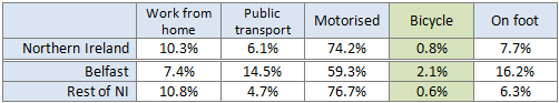
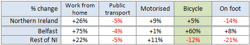
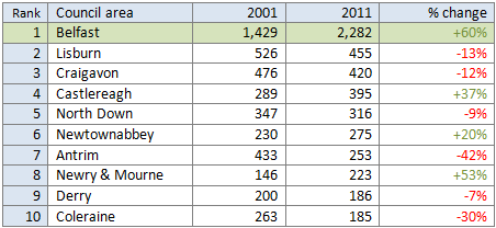
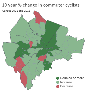
There are certain structural issues which influence main mode of transport choices in Belfast. The last map shows a close correlation between areas of high deprivation and lower percentages of household car ownership, and the opposite true of areas of lower deprivation. But the concentration of cycle commuting also closely matches areas of higher car ownership, so perhaps the assertion that bikes are luxury items in Belfast may hold some truth at present.

The Netherlands is the only country in Europe to have more bikes than people. Across Northern Ireland in 2011, just 39% of households owned at least one bike, and less than a quarter own two or more, making an ‘accompanied’ journey possible. These structural issues must be addressed alongside investment in safer routes if a bigger impact is to be made across all levels of society.

Urban cycling for all?

So is cycling to work in Belfast a mainly middle class activity? It is of course impossible, unreasonable and undesirable to attempt to assign labels to every person within a particular area, and many wards in Belfast have a mix of streets where deprivation levels vary greatly. However we can see clear evidence of lower cycling uptake in the more deprived areas of the city, and a localised cluster of higher commuter cycling modal share in more affluent wards. We can speculate on some of the factors at work for people and families in areas of highest deprivation:

  • high one-off cost to buy a commuter bike
  • the number of deprived wards within walking distance of main centres of employment
  • low concentration of leisure routes through communities in north and west Belfast eg Lagan Towpath in south, Comber Greenway in east
  • outer wards in north and west situated higher in the hills, physical effort perhaps makes cycling seem less attractive
  • larger concentrations of terraced housing stock providing less space for safe bike storage
  • a Belfast ‘Troubles’ quirk – a cheap, efficient and social alternative in dedicated black taxi ‘bus’ routes

A more detailed study would be needed to draw clearer conclusions on this. There is some interesting research work on cycling perspectives within deprived inner-city areas, and perhaps this is a rich vein for study in Belfast.

CyclingDecadeChangeBelfastThere is also some evidence that the 60% increase in commuter cyclists has been partly due to uptake in areas of higher deprivation, albeit from a low starting base in many instances. This is encouraging and needs to be built upon. One of the upcoming cycling projects in the city is the roll out of a council-led bike hire scheme. While this is more evidence of a growing awareness of cycling as a key urban transport mode, lessons from London should be heeded to ensure broad usage among all levels of society.

I’ve posted the partly financial reasons why I cycle to work in Belfast, and (excluding initial purchase and ongoing maintenance costs) cycling is effectively free transport. It seems reasonable to think that cycling should be viewed as a highly flexible and efficient form of urban transport, but also an option which weighs less heavily on a household budget than owning one or more cars. But it appears many people in the most deprived areas of Belfast are unable or unwilling to reap the many benefits of cycling.

There is a policy challenge here to assess why areas of Belfast are being left behind in adding cycling to their range of transport options, and to create city-wide conditions where cycling is a natural choice for everyone, not just the well-off.

As 2013 arrives, some of us will be taking stock of life, waistlines or bank accounts and deciding to start afresh with some New Year’s resolutions. It’s traditionally a bad time of year for the luxuries in life, while gym owners fill their boots on new memberships – before willpower inevitably fades.

Perhaps these are clichés, or maybe it is a good time to try something new. One of the barriers to making major a successful change in your lifestyle is finding time. There is one activity which ticks the fitness, finance and quality of life boxes, and doesn’t require significant extra time – cycling to work.

Why do I cycle to work?

It’s an easy argument to make as a regular bike commuter in Belfast, but here’s a secret – I don’t always cycle. I own a car, and I occasionally use it for the work run. I’ve been a regular commuter on the Metro bus system. I’ve even been known to walk to work too – it’s just under 3 miles door-to-door. Forget about labelling me as a “cyclist”. I’m a commuter.

But on balance I’ve made the decision to use the bike for commuting all year round for a number of reasons; the short distance, the time saved over other forms of transport, the money saved, and the regular exercise.

I’ve previously posted about why Belfast has the potential to be a great cycling city, and my own commuting journey is fairly typical in Belfast, a small city with a quite centralised employment. So why do more people not use a bike to get from A to B?

It turns out more people already are. In 2001 just 1.4% of Belfast workers listed cycling as their main form of commuter transport. Over 10 years, the number of people cycling has increased by 60%, and cycling now has a 2.1% share.

Comparing journey options

Using the bike certainly feels like the most efficient way to get to work. A steady 15 minutes maximum journey time for a trip of just under 3 miles, regardless of traffic conditions, and no per-journey costs. Even if I didn’t know the comparative journey times, the traffic queues are ever-present and fun to whizz past. Despite cars overtaking me in short stretches, I’ll consistently beat any car door-to-door. But as a multi-modal commuter, I can record and compare my transport options.

Assuming 233 working days a year (subtracting weekends and 28 days statutory leave) I can work out the actual cost savings I make by cycling over taking the car, the bus, or walking. These personal costs can be measured in time and money.

Bicycle vs walking

Walking compares favourably to cycling on cost, as each journey is free – unless you’re counting shoe wear. However, it takes the longest of all options, 45 to 50 minutes. Unless there’s a particular reason to walk (and in Belfast, issues such as flag protests do crop up), it’s not an attractive option. Compared to cycling, I lose 233 hours a year travelling, or 10 full days annually. This is time lost from home life and makes walking my least favoured option.

Bicycle vs bus

During rush hour, it is rare that any Metro bus will stay ahead of me for more than 2 stops. Indeed, the scheduled timetable puts the average rush hour speed at around 8mph, easily slower than the bike. The Metro system in Belfast means that my route has a regular 10 minute service at peak times. While this is very a reliable option, if I exclusively used the bus all year round, the service intervals means the average bus journey includes 5 minute wait at the bus stop. Adding two more 5 minute walks from stops to work and home means that my average journey time is already 15 minutes – the same as the cycling door-to-door – and I haven’t even added the actual bus journey part yet. This is a major disadvantage.

Overall I will lose 155 hours a year, or approximately 6 days, travelling by bus rather than by bike. Bus fares are £1.70 per journey, but if this was my main transport option, taking advantage of a Metro Smartlink card would see that discounted to £1.10. Still, over a year, that’s £513 pounds out of my pocket for slower journeys.

Bicycle vs car

Attempting to work out costs for my car faces a major variable factor – Belfast city centre parking. I don’t have access to a free car parking space, and I doubt many of us do. My two main choices are on-street parking around my workplace, or a cheaper ‘all-day’ car park.

The on-street option gives me an average door-to-door journey of 25 minutes, but at £1.20 per hour (£9.60 per day) it really hurts the wallet. The closest car park with a ‘commuter’ offer is Castle Court, which has a £4.50 maximum daily rate. However the trade-off is an extra 10 minutes per journey walking to/from work. Petrol costs only around 85p for the round trip each day.

Compared to the bicycle annually, using the car park I lose 155 hours (4 days) and I’m £1,247 worse off, while the on-street option sees me lose just 78 hours (approximately 3 days) but leaving me a whopping £2,435 poorer.

Comparing time and money costs of bike commuting vs walking / bus / car

TransportEfficiency2013

The significant personal journey costs of car commuting are not limited to this example, as the large monthly repayment hole in my bank account will attest. Depreciation, hefty insurance and VED costs, servicing and MOTs must be considered as well.

According to the 2011 Census, 40% of Belfast households have no access to a car or van, and the cost disadvantage must be one of the primary reasons.

Completing the comparison fairly, bikes themselves are not free. However, picking up your main form of transport for between £100-£300, and modest servicing costs from your friendly local bike shop, there really is no comparison to a car on cost.

Witness the fitness

Okay, this blog post can’t ignore the fitness aspect. First, if you met me in person you’d be unlikely to think ‘that person cycles every day’, so cycling to work won’t necessarily give you the figure of an Olympic athlete. But I’ve built 30 minutes of exercise into every working day. That’s a base level of activity that I’d need to find time for elsewhere in the day, for a trip to the gym or swimming pool – time most of us just don’t have. It’s also exactly what the NHS recommends as the level of physical activity needed to stay healthy. So if you want to sneak up on yourself with some exercise, burn a few more calories, and arrive at work invigorated rather than snoozing on the bus or frustrated by gridlock, cycling could be for you!

All things being equal

These are very basic comparisons, which ignore many aspects which are in favour of private car travel, or reduce the choices available to people. The challenge is laid firmly at the feet of the Northern Ireland government to create the conditions for real choice in Belfast.

Some jobs designate workers as essential car users, with sales posts and others requiring quick flexible transport on a daily basis. There is no doubt that the current public transport system, and road infrastructure, doesn’t offer realistic alternatives to some people. However, many arguments for car travel should be first evaluated with the query ‘how do they do it in the Netherlands?’ If cities elsewhere with similar climates have people happily getting on with commuting, shopping, doing the school run and more by bike, and can have modal shares upwards of 20%, even 30%, we’re failing if we say it can’t be done.

Local retailers cry foul when the status quo on our roads is altered, as we’ve seen with Belfast bus lanes. But research is starting to show that cycling customers spend more than car drivers. If the ‘shop local’ agenda is truly to help the many independent retailers dotted around our unique city, advocates need to take safe cycling and walking infrastructure seriously as a means to drive footfall and revenue.

A key argument against cycling infrastructure is that the car is the dominant travel form here because people make rational informed decisions on transport. When the government spends money on “sustainable”  transport, it is an artificial distortion of market forces, prioritising transport modes that will never, or need never threaten the motorised hegemony.

Choices are not equal though. If the main barrier to cycling uptake in Belfast remains fear of the roads, then until we have the type of cycling infrastructure where people of all abilities from 8 to 80 feel safe and secure, then it’s not an equal choice. Yes, this may mean segregation in some places, wide areas of 20mph residential streets as standard, better routes to schools, and a recognition that advertising, inconsistent cycle lanes and unenforced cycle boxes alone will not make a significant difference to uptake.

Despite the problems, a 60% increase in 10 years is good news. Why not think about trying the bike for work, seeing for yourself what the benefits are. Maybe your workplace already operates a cycle to work scheme? And if fear is putting you off, try asking you elected representatives for action on creating a better city for you and your family.

You can also use this handy cycle to work calculator if you want to try some calculations on what you could be saving.

Happy New Year!

LanyonBikePark

Census figures have given a boost to active travel in Belfast, showing a strong rise in the level of cycling in the city. In the ten years up to the 2011 Census, there has been a 60% rise in the number of Belfast residents using a bike as their main form of transport between their home and place of work.

Broad modal share for commuter cycling in Belfast has also jumped up by just over 50%, with cyclists now accounting for 2.1% of travel to work share, up from 1.4% in 2001.

The tables below show the method of travel to work for the employed working age population. I’ve compared the Northern Ireland headline figures with a split between Belfast Council area and the rest of NI excluding Belfast.

Method of travel to work (resident population) 2011
All persons (16-74 years) in employment and currently working

ShareTravelToWorkNI

Belfast has a much lower reliance on private motorised travel (Motorcycle, scooter, moped, car or van driver or passenger, can or van pool or taxi) than the rest of Northern Ireland, with greater usage of public transport (train, bus or minibus), walking, and now significantly over three times the rate of cycle commuting than the rest of Northern Ireland.

Change in method of travel to work (resident population) between 2001 and 2011
All persons (16-74 years) in employment and currently working

ChangeTravelToWorkNI

The headline Northern Ireland figure shows a rise in bicycle commuters of 5% between 2001 and 2011, but delving deeper shows that Belfast is starting to leave the rest of Northern Ireland behind in modal shift terms. Belfast has seen a massive 60% increase in cycle commuters, while the rest of NI has seen a fall of 12%. While this poses some difficult questions of NI-wide policies, there is a clear challenge to allow Belfast to forge ahead with a wholly separate strategy for urban utility and commuter cycling.

Private motorised travel to work, while on the rise in Northern Ireland as a whole, has stagnated in Belfast in the last decade. Yet interestingly, car or van pooling showed the biggest increase of any transport method in Belfast (80%) in part pointing to good work and outcomes from the Travelwise NI campaign.

Public transport has also seen a dip in numbers of commuters, mostly due to a reduction in bus passengers. The number of Belfast residents travelling to work by train has risen by 72%, but interestingly more than twice as many people living in Belfast cycle to work than take the train. Similarly train commuters have risen by 63% across NI, obscured in the public transport category by a 15% drop in bus commuters, a much larger group.

For more detailed information you can access the supporting data tables through the Census 2011: Key Statistics for Northern Ireland Statistics Bulletin on the NISRA website (PDF).

Belfast cycling on a different path

One of the main points for future policy is the growing divergence between cycling levels in Belfast and the rest of Northern Ireland. Data gathered by Roads Service from cycle counters in Belfast has shown a quiet groundswell of cycling uptake over ten years from 2000 to 2010. Over this period, cycle usage at key locations in Belfast has risen by a staggering 152%, with some of the most popular areas (Stranmillis Embankment, Albertbridge Road) showing increases well above 200%. The early indications are pointing to real year on year progress in Belfast cycling levels.

The census figures show, perhaps surprisingly, overall numbers of commuter cyclists have decreased in 19 of 26 district council areas in Northern Ireland since 2001. Of the top ten council areas by number of cycling workers, six have seen a decrease.

Top 10 councils by number of persons using a bicycle as main method of travel to work 2011
All persons  (16-74 years) in employment and currently working (resident population)

BikeToWorkCouncils

The Belfast Metropolitan Area (Belfast, Castlereagh, Carrickfergus, Lisburn, Newtownabbey and North Down councils) has seen a 30% rise in cycling as the main form of transport, but this is mostly due to Belfast adding 853 new cycle commuters against just 47 in the other five council areas combined.

Antrim, which had the fourth highest number of commuter cyclists in 2001, has seen a significant reduction of 42% in the last decade.

Taxis in bus lanes – the twist?

Recently DRD have signalled their intention to allow all taxis the use of bus lanes. A consultation received an overwhelmingly negative response, but DRD plan to press ahead. The majority of bus lanes in Northern Ireland are in Belfast. It is interesting to note that in the ten years to 2011, the number of people using taxis as a main mode of travel to work has decreased by 8% across Northern Ireland and by 24% in Belfast. This is compared to commuter cyclists rising by 5% across Northern Ireland and by 60% in Belfast. Comparing the absolute numbers, Belfast taxi commuters have dropped from 4,000 to 3,000, while commuter cyclists have increased from 1,400 to 2,300. This goes a little way to exposing the flawed reasoning as DRD move to prioritise taxi movements in bus lanes, to the expressed detriment of cyclists.

Belfast – a cycling city on the rise

The census figures released this week are broad headline travel to work statistics. As a previous blog post shows, we wait for a more detailed analysis of methods of travel to work by distance. For example in the South Belfast Parliamentary Constituency Area in 2001, cycling modal share for commuting journeys between 2-5km was already above 3%.

The rise to 2.1% for cycling as a method of travel to work is just the beginning for Belfast. The question we must ask of government departments, politicians and Belfast City Council is: do you want to build upon this, and how far will you commit to seeing it happen? These rises are set against soft policies of advisory cycle lanes, advanced stop line cycle boxes, education and awareness campaigns and a nascent cycle to work tax relief scheme. We even have a city bike hire scheme in the pipeline.

Supercharging these already impressive rises over the next ten years is possible with the right commitment to budget and priority. More hard measures such as quality cycle corridors instead of piecemeal unenforced/unenforceable cycle lanes, the Gasworks Bridge, junction priority and redesign can start to send a message to reluctant possible cyclists. Most importantly, better engagement and consultation with the daily cycle commuters can only help to identify the areas of greatest weakness, and boost the chances of working together to improve the city. DRD and Roads Service must recognise the growing importance of cycling as a form of urban transport in Belfast, and give much needed weight to our issues within the city’s network planning.

Notes to census figures

There are some comparability issues with the 2001 Census – more information can be downloaded from the NISRA website (PDF).

More detailed Travel to Work data will be released over the next 18 months. This will allow a more detailed look at cycling modal share increases over typical commuting journey ranges. 

Belfast cyclists who’ve visited cities in the Netherlands can’t help but be impressed by the dedicated, separated cycling infrastructure. We despair at the state of our own urban roads, with funny green coloured car parks called cycle lanes, and the ‘shared space’ of bus lanes about to be opened up to taxis. When we suggest Dutch-style separated cycle tracks, we’re told there isn’t enough road space, it’s too expensive, or there isn’t the demand.

Aaron Coulter’s fantastic mini series on Bicycling Belfast argues that some of Belfast’s roads are quite narrow, and to expect a fully separate network across the city isn’t realistic, at least in the short term. Certainly in Northern Ireland’s car-dominated society, with alternative urban transport spending being mainly focused on buses, priority for cycling isn’t currently on the agenda.

But these broad generalisations about space and cost mask something important. What about roads where space is not the main issue? Are there opportunities to actually implement sections of high quality separated cycle tracks in areas of Belfast?

Belfast ignoring Dutch cycling lessons

The following video shows a junction on a dual carriageway in ‘s-Hertogenbosch (Den Bosch), with a typical separate cycle track.

[youtube http://www.youtube.com/watch?v=gAYjUHKlH9k]

There are a few things to note here:

  • the location is quite central in Den Bosch
  • the speed limit on the dual carriageway is 50kph (31mph)
  • the majority of cyclists are school children as this is a Friday afternoon
  • there is a pedestrian pathway on the right hand side of the road

What strikes me about the scene is the space and priority given to cyclists during interactions with vehicles. Cycling on the track appears to be quite a serene experience. No-one has to pedal hard to keep up with vehicular traffic, and people are able to chat and relax. Vehicles accessing the side roads wait patiently for prioritised cyclists to pass. Not anything you would associate with road cycling in Belfast. You’d have to use the Comber Greenway, Lagan Towpath or Lough Shore routes to get close, but these are rarely complete A – B routes, and are not cycle tracks developed in parallel with the road network, save for a 1km section on the Stranmillis embankment.

What was really striking was how similar the road looked to somewhere in Belfast – the Upper Knockbreda Road. This is part of the A55 Outer Ring road in the city, providing a strategic link for traffic to the south and east of the city to avoid the centre for longer journeys.

[googlemaps https://maps.google.co.uk/maps?hl=en&ie=UTF8&t=h&layer=c&panoid=KVWInB5n9XFFd6BfkGdz2g&cbll=54.577064,-5.875565&cbp=13,64.67,,0,4.08&source=embed&ll=34.994004,4.746094&spn=21.525048,105.46875&z=3&output=svembed&w=600&h=150]

Some of the noted similarities:

  • Dual carriageway with a reduced urban speed limit (40mph in Belfast)
  • Turning junctions crossing the carriageway
  • Sections of off slips at junctions
  • Bus stops
  • Nearby schools (Knockbreda High, Lagan College, Grosvenor Grammar, Newtownbreda High)
  • Dedicated cycling provision*
  • Similar width (approx 30m Belfast, 35m Den Bosch)

* Yes, the Belfast road has dedicated cycling provision! In fact, cycle lanes were first put on stretches of this road over 10 years ago. So how does the experience of cycling this dual carriageway stack up against the Den Bosch example? I took a journey with my video camera on a 2.6km stretch from the Castlereagh Road to the Saintfield Road:

[youtube http://www.youtube.com/watch?v=8t85wvEE1xI]

This cycle route has been classically bolted on the existing road and pavement, with minimum thought or budget given to the actual needs of cycle users. The confusing jumps between shared pavement (two-way) and on-road (one way) cycling betrays a lack of care in planning. When on-road, cyclists are too close to fast moving traffic for comfort. When on the shared pavement, hazards include road signs, uncertainty about give way markings, and conflict with pedestrians – usually the understandable complaint of pedestrians intimidated by fast moving cyclists.

The arguments will rage over priority and demand – obviously far more people travel on this road in motor vehicles than cycle or walk. The classic argument is that people make rational choices on their method of travel, and if motor vehicles are the dominant mode, they must have priority.

Of course, as this road and most in Belfast show, the choice between cycling and driving is not an equal choice. The comfort and (perception of) safety of a car for a short journey will usually win out over fear of physical danger on a bad cycle route. Fear of traffic is a major barrier, and is not addressed properly in this example. People are not encouraged to cycle on this route so much as tolerated.

While on the periphery of the city, there are several important destinations along the Outer Ring which would greatly benefit from being connected by a high quality cycle route: the schools mentioned before, the Comber Greenway, the Lagan towpath, Belvoir Forest Park, the forthcoming Connswater Community Greenway, Cregagh Glen, the Forestside shopping complex, Knockbreda Healthcare Centre, and many more community connections and key arterial corridors.

Building unnecessary compromise into the network from the start, dooms proper development of cycling as a viable transport form. As we see from the Dutch video, good design principles of separation would see a cycle track ‘behind’ areas of conflict such as bus stops, or traffic signals like the one on this dual carriageway in Belfast:

[googlemaps https://maps.google.co.uk/?ie=UTF8&t=m&layer=c&panoid=fg0apcjHMzTbSrUO37Ea-w&cbll=54.576167,-5.87766&cbp=13,14.27,,0,11&source=embed&ll=4.039618,15.117188&spn=66.155769,210.9375&z=2&output=svembed&w=600&h=200]

The difficult areas in the video, when encountering (very low frequency service) bus stops, or cycle lanes on the inside of off slips, show extremely poor design. Taken from the viewpoint of making the least difficulties for general traffic, they are understandable choices – where space is judged too tight, pedestrians and cyclists lose out to traffic needs.

My own view is that separate cycle tracks are actually easy to achieve, given the right budgetary conditions and road space. It’s all of the other aspects of Dutch cycling which prevent road engineers here from implementing them – junction priorities and design, crossings, roundabout design, and strict liability principles. The design manual is either sorely lacking, or there is no willingness think creatively.

Roads Service blind to best practice

As with many of Belfast’s investments in cycling – mainly unenforceable advisory cycle lanes – this is a wasted opportunity. This section is part of a 4.7km project, with cycle lanes or shared paths mostly on both sides of the dual carriageway. The total project spend was just £77,000, very modest when compared to European norms, but money spent nonetheless – and now lost to inadequate infrastructure.

These excerpts from the Roads Service Progress Report to Castlereagh Borough Council (where this road is located) in August 2006 highlight the aspirational rhetoric on local cycling infrastructure, which isn’t matched in reality:

“Whilst usage levels of these routes are not high, they were intended to separate cyclists from other vehicles on heavily trafficked roads to increase safety.”

By any measure, the Upper Knockbreda Road is a fast and busy dual carriageway, despite the 40mph limit. Putting a mandatory cycle lane on the road is not separation, and cyclists would struggle to feel safe here.

“Other cities in GB and in Europe (including those with climatic and topographical characteristics similar to our own) have changed the transport habits of their citizens and achieved proportions of journeys made by bicycle many times higher than here. It is clear that if good facilities are provided and marketed, people will be happy to use them in very significant numbers, to their own benefit, and to the benefit the environment.”

Roads Service are keen to reference best practice from Europe here, and even go some way to knocking down a tired argument about climate being a unique barrier to cycling uptake in Belfast. But it is disingenuous to place this in a report, when the cycle facilities provided do not come close to European best practice. Interestingly, despite this being one of Belfast’s longest mandatory cycle lanes, and on a key strategic transport route, there are no cycle counters installed to measure usage. Belfast has a number of these, which have shown an overall increase of 152% during the time this particular route has been operating. But usage here remains unrecorded.

Belfast cyclists are becoming more aware of the attitudes within Roads Service to cycling as transport, ranging from indifference to hostility, laced with a lack of understanding of cycle users’ needs. Recent initiatives such as Reclaim Belfast’s Cycle Lanes are demonstrating that even our inadequate infrastructure isn’t available when it should be.

However Roads Service must maintain the appearance that active travel is core to it’s investment. The June 2002 report to Castlereagh Borough Council was fronted by an image of the redesigned Knock dual carriageway, as a high profile example of cycling needs being catered for. It speaks volumes for the understanding and importance of cycling to Roads Service that no-one had the wit to notice the two cars illegally blocking the mandatory cycle lane. This was clearly during the afternoon school run, at the very time the cycle lane should be used most (if you’d feel happy letting your children use the lane).

How long can Belfast ignore the Dutch?

There are plenty of areas in Belfast with no cycling infrastructure at all which need urgent attention. It is unreasonable to ask for a Dutch-style cycle track to be built on this road in the short term – in many ways the cycling ship has sailed on this road. For future projects with adequate road space, Roads Service need to understand that there is a better way to design cycle infrastructure. Public money is spent by Roads Service on cycling measures which are designed to fit in where possible, leaving a disjointed, confusing and muddled network, unfit for use by all ages, and failing to provide safe high quality cycle tracks to attract more people out of their cars.

Roads Service need to be directed, and empowered, by pressing targets and dedicated budget to design projects with the needs of cycle users at their core. We can’t afford to keep missing opportunities like this.

It’s no mistake that cycling levels and safety are so good in the Netherlands. It is a mistake to think that we can ignore best practice, and try to design successful cycle networks which cater for motorists’ needs rather than cyclists. While we continue down this path we waste good money, and waste chances to make a real impact on Belfast cycling.