Belfast is in the middle of a mini active travel boom, mainly driven by rising numbers of bike commuters. But Belfast suffers from structural issues which hold back cycling development, not least the physical barrier of the River Lagan. One plan to provide relief, a new pedestrian and cycling bridge linking the Gasworks site to Ormeau Park, has been largely forgotten. Why?

River Lagan from the Gasworks side

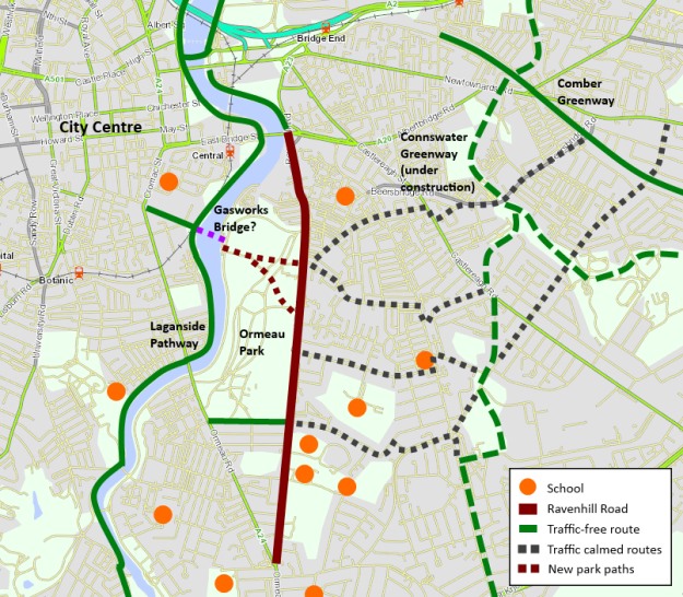
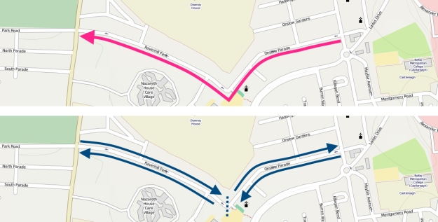
The Gasworks Bridge would span 140m between the Lagan entrance to the Gasworks Site and the Ravenhill Reach car park beside Ormeau Park. The project cost is estimated in the region of £4million to £8million. The benefits to the city have been clear for many years:

  • greater access for people in South and East Belfast to the city centre
  • making Ormeau Park a city centre park, accessible by both residents and workers, 15 minute walk from City Hall
  • provide safer pedestrian and cycling options than Albert Bridge and Ormeau Bridge
  • increase in walking and cycling with the health, leisure and transport benefits
  • further encouraging inner city regeneration with a new signature city gateway

This would be the first standalone bridge to be built in Belfast solely for cycling and walking journeys – an important signal of intention to follow through on active travel promotion. Local residents surveys have always returned positive views, with few concerns about potential interface issues. All very positive, but it seems to have dropped off the agenda.

Why is it important?

The spine of the National Cycle Network runs along the western bank of the River Lagan here, connecting a traffic-free route stretching from Lisburn to Newtownabbey, a developing connection to the Comber Greenway (and the Connswater Greenway project) and hopefully all the way to Bangor in the future. The embankment cycle tracks and shared pathways have contributed to an upsurge in active travel, with cycling flow increases of over 250% observed between 2000-2010 (PDF, 499k).

Gasworks from Ravenhill Reach
View from Ravenhill Reach looking down Gasworks / Ormeau Avenue corridor

Adding the bridge would open up east-west journeys on the National Cycle Network, increasing the potential of the Gasworks Park pathway which links almost directly into the city centre. The Gasworks Park hosts large employers like Lloyds and the Northern Ireland Environment Agency, but also the Radisson SAS Hotel. The bridge would not only be a commuter and lunchtime leisure option, but also a tourist facility.

For walking journeys to work, Shaftesbury and Botanic wards lead the way with over 40% of commuter ‘traffic’ on foot. Yet just across the river there is a sharp drop-off with Woodstock and Ballynafeigh wards around 25% and Ravenhill less than 20%. Physical disconnection is at least partly responsible, with long diversions needed to reach the main employment base in the city centre.

The communities surrounding Ormeau Park are also at the forefront of the the current cycling boom. While still quite low levels compared to proper cycling cities around the world, nonetheless Woodstock, Ravenhill and Ballynafeigh are the top 3 wards in the whole of Northern Ireland by cycling commuter share at 5-6%.

© Crown Copyright Land and Property Services / Spatial NI
Commuter cycling share in wards surrounding Gasworks bridge (Census 2011)

A startling 51% of households in Woodstock have no access to a car or van (Census 2011) over double the rate of Northern Ireland as a whole. Direct traffic-free access into the city centre is both desirable and necessary here.

Belfast has seen a 60% rise in cycling commuters between 2001 and 2011. If a Gasworks Bridge contributed to a doubling of cycling levels in these top 3 wards by 2021, cycling levels would outstrip even bus commuting here, which begins to fundamentally change the inner city transport dynamics.

By upgrading cycling routes beyond Ormeau Park, across traffic-calmed residential streets towards Cregagh and Castlereagh Roads and the two Greenways, a genuine and attractive alternative to car travel becomes possible for a large part of South East Belfast. A positive impact on inner city traffic levels must be considered a key element of the bridge’s benefit.

What are the alternative cycling commuter routes?

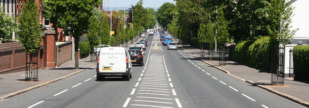
The existing connections between the city centre and the suburbs of South and East Belfast have become scenes of cycling commuter stress and conflict. The area is poorly served by just two main access points across the Lagan a mile apart, the Ormeau Bridge and the Albert Bridge.

Side of Albert Bridge Belfast
The Albert Bridge in Belfast, a major barrier to cycling uptake in East Belfast

The Albert Bridge is awful for cycling, with it’s narrow road space, ugly crash barriers and no safe cycle space. Roads Service estimates 50% of cyclists use the narrow footpaths rather than the road. Yet as a listed bridge (built in 1890) the options for change are apparently limited.

Ormeau Bridge Belfast
The Ormeau Bridge in Belfast, possibly the busiest cycling intersection in NI

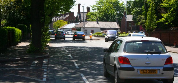
The Ormeau Bridge has a more open feel, but again has no dedicated cycling space. The ghost bike memorial for Michael Caulfield is a stark reminder of how dangerous our roads are for cycling – more so as the Ormeau bridge and embankment intersection is probably the busiest area in Northern Ireland for commuter cycling.

Why has the project faltered before?

Planners have had their eye on a bridge here for decades, but not always for a footbridge. In the rush to build for a motorised future, 1960s plans foresaw an urban motorway running around the Gasworks site and over to Ravenhill. While the motorway plan thankfully fell away in the 70’s, the idea of a more modest distributor road bridging the Lagan and running to the Ravenhill Road lingered through to the 1990s. Along with the main plan for a southern inner ring road, currently in limbo, this has contributed to urban blight through restricted development along the Bankmore corridor.

© Copyright Albert Bridge and licensed for reuse under Creative Commons Licence
Bankmore Street, effectively abandoned to a road scheme that never happened

Lately with the recognition that a road scheme would not be viable or attractive, and the redeveloped Gasworks site opening in 2001,  the idea of a traffic-free bridge moved up the agenda. Boosted by the inclusion in the Belfast Metropolitan Transport Plan 2015, it seemed obvious that the bridge would be built quickly, given the success of the wider Gasworks and Laganside projects:

“Two new pedestrian/cycle bridge crossings are proposed to serve key activity spines between the east and western sides of the River Lagan. These will improve the connection between the extension of existing riverside walkways and the more strategic sections of the pedestrian network. These bridges will be funded as part of  the regeneration of Belfast.”

Rumblings of trouble can be seen in a Belfast City Council Development Committee report from 2005, when you look at the number of ‘stakeholders’:

  • Laganside Corporation – Gasworks and riverside regeneration
  • Department for Social Development (DSD) – public realm schemes and Laganside Corporation’s sponsor
  • Belfast City Council – owner and operator of land and facilities on both sides of the river
  • Sustrans – the National Cycle Network runs through the middle of the issue
  • Department of Regional Development (DRD) – NI transport planning and infrastructure, including active travel

Lots of interested parties, but no-one to take a clear lead. It was unfortunate timing that the Laganside Corporation was wound up within 2 years of this, having reached £1 billion of investment in the city.

Lagan looking toward the Gasworks Bridge location

The last major push was around 2009, with talk of the project even being linked to the failed national stadium bid at Ormeau Park. An application for Special EU Programmes Body (SEUPB) Peace III funding “fell down on its demonstration of peace and reconciliation outcomes and its ability to provide a lasting legacy to the peace programme”.

If we’re relying on a 140m river crossing to be a transformative factor in community relations and breaking down sectarian divisions, what hope is there for Northern Ireland? EU Peace funding has been practically ruled out, and the reason is clear when you cut through the ‘additional’ benefits and set out the purpose of the bridge in basic terms:

The project’s most important function is to provide a new transport corridor in Belfast.

Therefore it falls squarely within the remit of DRD and their executive agency Roads Service. A Belfast City Council Development Committee report on the potential construction and maintenance of the bridge from back in 2005 shines a troublesome light on DRD active transport thinking:

“It is obvious that responsibility for the project should be taken up by Roads Service. Initial contact with Roads Service has however been met with a lukewarm response despite the rhetoric in the BMTP etc in regard to walking and cycling as valid means of transport.”

Can DRD to demonstrate they have moved beyond this point, and take ownership of a major project exclusively for active travel? Is there a golden window of opportunity given the ongoing difficulties with the A5 road project?

What is the way forward?

The recently opened Peace Bridge in Derry~Londonderry is a fantastic local example of what can be achieved for urban cycling and walking transport. Around 2,300 people use the bridge every day, and is a challenge to Belfast to replicate or exceed this impressive performance.

PeaceBridge1
The Peace Bridge in Derry~Londonderry

For an international comparison, Copenhagen is one of the leading cities in the world for urban cycling, with a journey share of around 36%. But it’s a city still trying striving to improve, and leading this charge with urban bridge building for non-motorised traffic with the Copenhagen harbour bridges project.

Gemini Residence 3
Bryggebroen cycling and pedestrian bridge in Copenhagen

The Gasworks Bridge is a key element of re-imagining and reworking central Belfast. Council plans are afoot for sweeping regeneration from the Markets area to Sandy Row and Shaftesbury Square. The bridge would open up new possibilities for commuting, leisure, shopping and social trips that aren’t really viable today. It’s easy to overplay the significance, but the bridge even has the potential to help boost the evening economy in the city.

The Gasworks Bridge is a key part of the Belfast Metropolitan Transport Plan 2015, which is still used to determine capital project priority in the current budget period. If the DRD Minister should wish to leave a legacy for Belfast which provides positive encouragement to reduce car journeys, he would struggle to find a better opportunity than the Gasworks Bridge.
.
[youtube http://www.youtube.com/watch?v=GtjBjgHkAAM?rel=0]

What do you think about the idea of a Gasworks Bridge? Will it encourage you to ditch the car? Comments are open below..

*** UPDATE *** 20th June 2013 *** UPDATE ***

A week is a long time in politics, and one week on from this post there is stunning news. Regional Development Minister Danny Kennedy, while addressing the Politically Painless Active Travel conference in Belfast, announced he is to commission a feasibility study into the Gasworks Bridge project!

Danny Kennedy Gasworks Bridge

This is great news for the local community, active travel organisations, councillors and many others who have put in the real work over a decade to see this bridge built. Hopefully DRD / Roads Service will make swift progress, and the project’s overwhelming benefits will ensure a positive outcome. The potential to transform this part of Belfast is immense – with Belfast cycling on the rise, it seems the Gasworks Bridge’s time has come!

With the Gasworks Bridge back on the agenda for Belfast, regular cycling may become a serious transport option for many people in southeast Belfast. Yet the current barriers to cycling must be overcome to extract maximum benefit for the people of Belfast. The Ravenhill Road may become the focal point to set a new Belfast standard for designing roads for people, not vehicles. By looking at best practice from the Netherlands, a simple plan can be set out to revolutionise the experience of cycling in Belfast, and provide the backbone for a new high density active travel network.

Ravenhill1
Ravenhill Road layout at Cherryvale Park entrance, central island dominates the road

Ravenhill is a ‘B’ road which suffers from being the most direct route between the northern and southern sections of Belfast’s ring road. Yet it’s also a narrow, leafy residential road, with two major parks, large schools and a handful of locally-focused businesses – a quiet backwater in contrast to the bustling parallel Ormeau and Cregagh Roads.

It also runs through the highest density of cycling commuters in Northern Ireland, with around 5% of residents from Ormeau to Cregagh choosing to regularly bike to work. Yet there is little evidence of a wider cycling culture here outside of the typical commuter profile. The current advisory cycle lanes send out the message that cycling is for commuters only, and contributes to the unhealthy gender profile of Belfast cyclists.

To open up journeys to everyone – young and old, men and women, families, shopping trips, leisure rides, all day and night – needs a tried and tested simple solution, dutch-style separation. If your instinct says this is too radical for Belfast, you might be surprised to know an example of high quality separation is just 200 metres away.

RavenhillOverview

Planning for the Ravenhill Road to become an important link in many journeys between suburbs and centre, and between parallel greenways, requires 3 simple steps.

Separation

Whether through lack of funding, commitment or vision, Belfast’s cycle network has been allowed to develop as a series of disjointed on-road lanes. Worse still, they are designed around the needs of motor traffic – exceptional at keeping cyclists out of the way of cars, vans and trucks in higher speed sections where conflict isn’t necessarily an issue, and removed when cyclists’ needs are greatest, at junctions and roundabouts.

OrmeauRoundabout

Predictably the cycle lanes disappear at the approach to the Ormeau Road roundabout. Less forgivable is the disappearance at the other end of the Ravenhill Road, solely to cater for traffic using a major city rat run at My Lady’s Road (see video).

The issues with advisory cycle lanes in Belfast are well known to readers of this blog, and the Ravenhill Road has featured on the Reclaim Belfast’s Cycle Lanes two surveys. Each side of the road has an urban clearway for 1.5 hours each weekday, which means for 96% of the week parking is perfectly legal; these spaces cannot truthfully be described as “cycle lanes”.

The following video shows how the quiet adjacent Park Road has a high quality separate lane, while the busier Ravenhill Road has much poorer facilities in comparison.

Paint on the road will not encourage parents to let children ride to school alone, parents to take small kids to nursery on bikes, those too afraid to cycle into the city centre to work, or for short trips to the shops. This approach has delivered little more than 2% of traffic on bikes across Belfast. It’s time to take a bold step –  redesign a major road with fully separate cycling infrastructure.

Redesigning Ravenhill Road

The current road layout is quite standard for Belfast, with:

  • a fairly consistent 16.5m span
  • roomy footpaths
  • on-road advisory cycle lanes
  • 2 traffic running lanes
  • a central island lane running almost the full length to aide turning movements

RavenhillLayout

Taking inspiration from Haarlem in the Netherlands, a reworked configuration would see the central island lane removed. Two running lanes are retained at approximately 3 metres each way, with 2 metre footpaths and 2 metre cycle tracks with a standard 0.5 metre kerb separation from the carriageway.

Separation benefits cyclist not just through actual safety and the perception of safety, but also removes limitations of being part of traffic. Short side road to side road trips are possible on a two-way cycle track on either side of the road, allowing many children to cycle to school without having to cross a road to join traffic.

Haarlem
Balanced roadspace allocation in Haarlem on similar road footprint

What about the tough places where the cycle lanes disappear? Again the Netherlands have decades of experience when it comes to junction design. The Ormeau Road roundabout may be jealously guarded by road engineers, but the Park Road/Ravenhill Park junction is ripe for a Dutch-style experiment, and the Ormeau Embankment junction could benefit from a southbound pass-through lane and better separation on the other approaches.

[youtube=http://www.youtube.com/watch?v=FlApbxLz6pA&w=640&h=360]

Traffic calming

Ravenhill Road

The loss of right hand turning boxes may be the most controversial suggestion, but consider how Roads Service balance the needs of all roads users with this central island. Running between Ravenhill Avenue and Rosetta Park (1.8km) there are 22 turning spaces for vehicles, compared to just 7 pedestrian crossings, and only two of those give pedestrian priority (pelican crossings). Vehicle needs and safety trumping those of vulnerable road users.

RavenhillCrossing

For the majority of desire lines (at more than 20 side roads and paths) there is no direct crossing, so people are forced to wait for a break in the traffic to cross, or make a long diversion.

Creating a series of zebra crossings on the redesigned road to cater for more pedestrians and cyclist crossing is essential. The needs of through-traffic from the south of Belfast and beyond to the city centre must be placed second to the needs of local users, especially those walking or cycling the school run.

In rural areas the right hand turning box is primarily a safety feature. In a 30mph urban/residential road it is there to enable the efficient flow of traffic around turning cars. It’s time to consider whether high average traffic speed should be the goal of urban road design, especially if it suppresses other transport needs and more liveable streets.

Side streets

The success of cycling in the Netherlands isn’t solely about separation. There is the understanding and empathy fostered by virtually the entire population cycling, and sustainable safety principles governing all aspects of design, not least at junctions and side roads.

Looking at the example below, cycle tracks and footpaths continue across side roads, giving priority to the more vulnerable users, but also a strong visual cue that you’re entering a different classification of road, and the sense of needing to adjust speed.

HaarlemExample
How side road access could be reworked on Ravenhill and pedestrian crossing example

You might think road regulations won’t allow for such a design in Northern Ireland; you may not be right.

The rat run at My Lady’s Road is a blog post in itself for another time, and London Road and Ravenhill Avenue don’t suffer from particularly heavy traffic flows – traditional calming methods could be easily deployed to discourage through-traffic.

Conall McDevitt’s 20mph Bill will be debated in the Assembly in the Autumn, and is understood not to be supported by the Department for Regional Development. Blanket 20mph limits on the residential streets here would be a great boost to active travel.

Ravenhill Park

To develop a high quality east-west cycling corridor with Ravenhill Road as the axis requires one major piece of road management. Linking the Connswater Greenway at Cregagh to the Ormeau Park and Lagan Towpath is possible by creating a traffic-calmed route along Ravenhill Park.

At the moment Ravenhill Park is one-way going west, which makes it a fast popular rat run route for traffic trying to reach the Ormeau Road from East Belfast. It’s also an unnecessary barrier to eastbound cycling journeys using the Park Road cycle lane – even (illegal) footpath cycling against the traffic isn’t possible due to high kerbs.

A simple, if radical, solution would be making Ravenhill Park and Onslow Parade 2-way again, but placing a barrier to vehicles beside Ravenhill Rugby Ground – removing all through traffic, calming speeds to solely residential users, and opening a new cycling corridor. Retractable bollards would be an ideal solution to allow fully flexible traffic management for Ulster Rugby matches and events at the new Ravenhill Rugby Ground. The Onslow side has a natural cul-de-sac turning circle at the stadium, and the nearby Ravenhill Park Gardens junction could provide a similar function on the park side.

Ravenhill Park Small

Eastbound rat run traffic is unlikely to divert to Ardenlee Avenue, reverting to the more suitable Mount Merrion corridor. Westbound traffic wishing to use Park Road and Ardenlee as a cut-through from Ormeau to Cregagh can be discouraged by the lack of right turning boxes, changing the design of Ardenlee to a more residential style with raised entrances and cycle track priority, and further traffic calming.

Ormeau Park cycleways

Ormeau Park actually creates a minor barrier to the success of the future Gasworks Bridge. To be a truly transformative active transport corridor, new cycleways across the park, with lighting for the winter months, would be needed to for the most efficient journeys.

The lack of a bridge over the Lagan means there are no direct ‘desire line’ paths going east-west across the park. The ‘cage gate’ entrances designed to discourage cycling and prevent motorcycles accessing the park must be replaced with a better solution.

[youtube=http://www.youtube.com/watch?v=hZEum3RpJ8I&w=640&h=360]

Belfast City Council’s parks opening hours (7.30am in the morning until sunset, as early as 5pm in the winter) would also cut into a large portion of homeward ‘rush hour’ and the potential to drive citybound evening economy journeys. Diverting people around the park would make the corridor and cycling less attractive. Ormeau Park would need a new 6am to midnight year-round policy.

Re-imagine Belfast and demand better

The potential Gasworks Bridge opens a range of possibilities and the chance for new thinking on how to move people around Belfast. Our streets are dominated by vehicles, but this is as much down to road design as to personal preference. Ideas and discussion are important to changing mindsets and building the space for active travel. In a city with rising congestion, falling car ownership, troubling levels of obesity and a more dangerous environment for cycling, tacking little bits of advisory cycle lane onto intimidating roads is no longer an acceptable waste use of public money.

Northern Ireland must learn from and implement best practice from the Netherlands for how to develop the safest and most attractive cycling space. This is how London is approaching its cycling vision, and Belfast realistically has an opportunity to lead the United Kingdom in cycling uptake, given the natural advantages for cycling. Belfast Bike Hire, the Giro D’Italia, rising commuter levels, the Gasworks Bridge – the stars are aligning for something truly special to happen in our city.

Give the people safe space to cycle and they will choose to do so in droves. Continue to pretend that Belfast’s roads are fit to promote as an genuine active travel option and we will all lose.