Perhaps the Belfast Harbour Commissioners don’t yet realise the significance of what they’ve created on Sydenham Road.

In a sense their separate cycle path (arguably the best stretch in the city) is an interesting symbol of the changing nature of Belfast’s Harbour Estate. The area is moving further away from the days of heavy industry to a clever future mix of innovation, education, high skilled jobs with big inward investors, start-up hubs, urban sport parks, education campuses, signature tourism and leisure facilities. With a new resident population growing in hi-spec apartment space, and commuter traffic growing, the area needs a smart, modern transport mix to thrive.
SydSTB
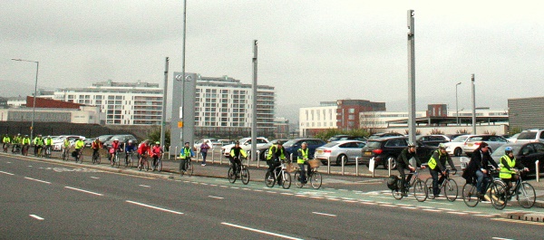
Peloton travelling along Sydenham Road to the opening of the Sam Thompson Bridge

The path was constructed in spring 2013, part of better defined road space. Two extremely wide lanes were split into 4 with the additional space used to create a wide 2-way cycle path, fully kerb separated. Although general traffic capacity was technically doubled, this was still a remarkable example of taking road space away from motor vehicles for cycling – on private land as well.

Who better to get on with the relatively insignificant job of road space reallocation than the Belfast Harbour Commissioners. This organisation, and their forebears, moved heaven and (literally) earth to create and shape a great port city from the sandy shallows of a lough which used to be named after Carrickfergus, the former primary settlement.

Belfast Harbour sits at the junction of 4 great cycling routes – the Lagan Towpath, Loughshore Path, Comber Greenway and Connswater Greenway. With the new Sam Thompson Bridge sited within the Harbour Estate and the ongoing positive reception for the Connswater project, Belfast Harbour is now a key link in Belfast’s active travel chain.

Some clever touches at the points of greatest potential conflict on the Sydenham road cycle path (such as the car showroom access) show there has been real thought about safety and comfort of all road users:

Yet, the Sydenham Road cycle path is in danger of being the Harbour’s high-water mark, as current expansion work and outstanding issues mean the quality of the route is beginning to recede. So what are the problems and potential solutions to the Sydenham Road route?

New shared pavement at Dee Street roundabout

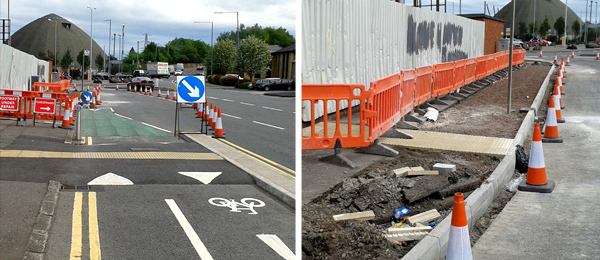
Rumours of works to the Sydenham Road route drew me down to the area in May, and it was disappointing to see a shared footpath solution being constructed at the Dee Street roundabout. From excellent separate #space4cycling to an awful compromise within metres. This is the classic approach to cycle design in Belfast; a cycle lane (and a magnificent one in this case) built where space is easy to take from general traffic, but at major junctions cycling space must disappear to meet the needs of motor vehicles.
Sydenham Road transition from cycle path to shared footway
From high quality separate cycle path to shared footway (with bus stop pole at transition)

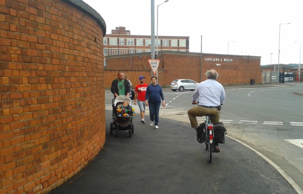
More worrying is the lack of thought about the curve to access the new crossing to Airport Road. After passing a prominent electricity box, a high brick wall obscures the view on a turn which greater than 90 degrees. Faster bicycle traffic will mix with pedestrians here, and the potential for collisions at peak times is now very high.
Wall
A surprisingly busy (now shared-use) blind corner with a difficult mix of users

As nice as the brick wall is, Belfast Harbour could remove it to create more space for dedicated separated cycling and walking space on this roundabout. (Update 26 Jun 14 – reliably informed this wall belongs to a tenant company, so “..Belfast Harbour could approach them to remove it..”) Alternatively, a three-lane roundabout can afford to have enough space clipped off to provide a more continuous cycle route – plenty of examples of best practice exist in the Netherlands.

Smarter investment in altering the roundabout design would also go some way to solving the maddening problem of citybound access to the cycle path from Dee Street and the Sydenham Bypass. If you’re confident enough to have crossed a double roundabout (with very heavy traffic) you have to get from one side of a fast and noisy 4 lane carriageway to the other. It’s utterly impractical and quite dangerous (even when dismounting and trying to walk) for families or inexperience cyclists.

Sydenham
No controlled crossing at the start of the cycle path – a 4 lane nightmare to traverse

Belfast Harbour had a great chance to make a vast improvement on the Odyssey to Victoria Park route; instead the Dee Street roundabout area remains its weakest link.

Ramps

A big favourite with patrons of the Belfast Cycling Study Tour, the ramps on the cycle path made little sense, especially given the harsh angles which lead many people to use the road instead. Even at low speed, these provide a hefty jolt to bicycle and rider.

Ramps
Badly engineered ramps mean bicycles and riders take a thumping

Many people wondered why these traffic calming speed humps were missing from the main road.. 😉

Following complaints, Belfast Harbour (to their credit) have altered the approaches on the ‘bus stop ramp’ to allow a smooth transit.
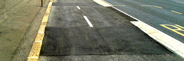
Sydenham Road ramp after works
Belfast Harbour have now eased the angles on one ramp

Yet, strangely, the final ramp near the Dee Street roundabout remains in its original spoke-snapping shape. Unlike the central ramp, which serves a pedestrian crossing to Titanic Quarter train station, the purpose here seems only to access to a bin and post box. The balance of inconveniences seem badly skewed against dozens of everyday users.
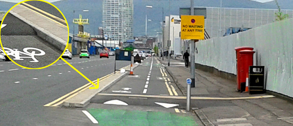
Sydenham Road ramp for post box and bin
Remaining ramp with poor angles, serving just a post box and bin

This final problem ramp needs to either be removed completely or the approaches flattened as above.

Route inconsistency

While the main separate cycle path is (bar a few minor bumps) a joy, the Odyssey to Victoria Park route is neither consistent nor continuous – the mark of great cycling infrastructure around the world. If you have to think too much about where you can or can’t be; if signage isn’t clear; if you have to take difficult and seemingly unnecessary diversions; if you inconvenience people, you are not encouraging the use of bicycles.

From the Odyssey, you either start on the footway or on the road – there is no dedicated cycling space. At the Queens Road junction you’ll meet this generously wide cycle lane.
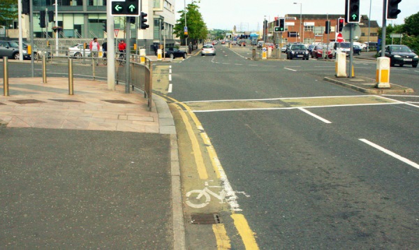
Sydenham Road yellow line cycle lane
Possibly the worst cycle lane in Belfast, just metres from the best

Held for an eternity at the traffic lights (sustainable transport journeys really need to have some advantage over motor traffic) you move across an advisory cycle lane and up a ramp onto a shared footway. Not too bad, except coming back the other way the visual queue is to cycle against the traffic – lethal if not illegal?
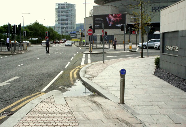
PermaPuddle2
Ramp invites you to cycle onto the road against the traffic

At the next junction is a similar ramp, with more confusion – cycling down the ramp onto the road doesn’t seem to be affected by the adjacent signal-controlled junction. While many would feel it’s prudent to wait, there’s nothing to caution users that cycling down into the junction is potentially dangerous – leaving a real threat of collision. Where would the responsibility lie?

Ramp1
Do you stop at a red light? Who has priority if you proceed?

The right hand side of the picture above says it all. If you’ve designed a dedicated route for cycling, and you feel that the road beside still needs an advanced stop line for bicycles, your design has failed.

Drainage

Not only do users have to contend with several transitions between shared and dedicated space, but those transitions themselves suffer from poor implementation. A lack of drainage is causing ‘perma-puddles’ to build up. As an occasional inconvenience perhaps not too bad, but the water sits for weeks at a time (even through dry spells, as in the picture) leading to murky, muddy pools gathering dirt and moss. People commuting to work risk getting clothes dirty, and chances of slips and falls are increased.
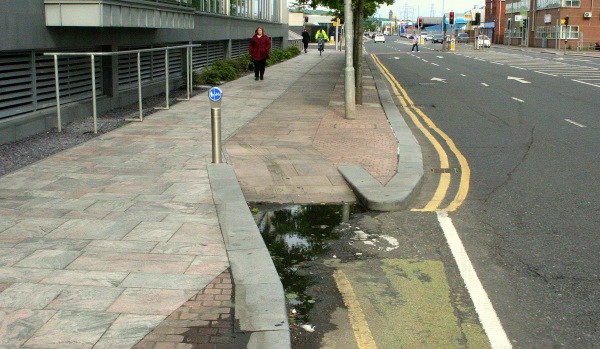
PermaPuddle1
Slippy perma-puddle on a transition ramp from road to shared footpath

Bad enough that one perma-puddle exists, but given that a new transition has just been created, lessons clearly haven’t been learnt.
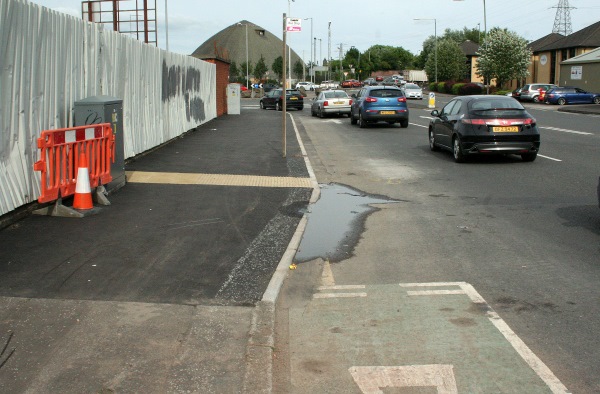
PermaPuddle3
Second perma-puddle – transition has a treacherous raised kerb, and a bus stop sign

Updated 17th June 2014

Remarkably (planned) work has been carried out to attempt to fix the drainage issues, as seen on the way to Stormont during Tuesday rush hour:
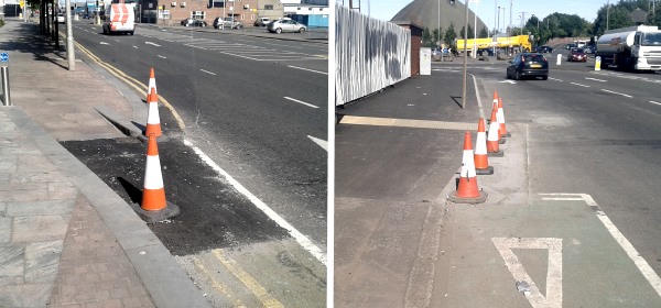
Works

Hopefully this solves the drainage problems, and shows that Belfast Harbour are sensitive to the issues on this cycle route.

Belfast Harbour’s legacy wasn’t build on cheap solutions

Belfast Harbour is now firmly in the business of cycle route planning and design. If they deliver cycle space of a poor standard, it reflects badly on the neighbouring routes at Laganside and the Connswater Greenway, dragging down their potential too.

Over the long decades, generations of Harbour Commissioners and the industries and trade they’ve fostered have done things on a grand scale – city building, airplane manufacture, Hollywood film production, launching the most famous ocean liners in the world.

While NI hopes that DRD’s new Cycling Unit is learning from cycling infrastructure best practice around the world, the industry and output from Belfast Harbour has always sought to be world-leading. Why should the Harbour’s cycle space be any different?

That Sydenham Road chatter..

Fat Bloke On A Pushbike Blog: The Sydenham Road Cycle Lane – My View

https://twitter.com/individualjs/status/444838843062419456

Building high quality separated cycle paths isn’t possible.

Belfast’s roads are too narrow.

This is one of the many default arguments against investing in the type of cycling infrastructure seen in the Netherlands or Copenhagen. Sometimes it’s worth looking at the urban landscape from a different perspective..

Decorative cobble lane, Belfast City Hall

Continue reading “Right under our noses”

As part of Bike Week, local people who cycle our streets share their stories, fears and hopes. Tony, originally for Omagh but a long-time resident in Glengormley, is one of the Pro Vice-Chancellors at Queen’s University Belfast (QUB), looking after planning, staffing and external affairs for the University. He explains his passion for cycling for transport and leisure..

I’ve been cycling for about a decade, and own a touring bike, a mountain bike and a road bike. I use the road bike most of the time, but occasionally take the mountain bike for a spin around Cavehill. I have 4 daughters, 2 of whom cycle fairly regularly, though one has been curtailed since her bike was stolen. Apart from the bicycle I use a motorbike – I’ve never driven a car and have no plans to start.

Tony - Why I Cycle

Continue reading “Tony: Why I Cycle”

Belfast is in the middle of a mini active travel boom, mainly driven by rising numbers of bike commuters. But Belfast suffers from structural issues which hold back cycling development, not least the physical barrier of the River Lagan. One plan to provide relief, a new pedestrian and cycling bridge linking the Gasworks site to Ormeau Park, has been largely forgotten. Why?

River Lagan from the Gasworks side

The Gasworks Bridge would span 140m between the Lagan entrance to the Gasworks Site and the Ravenhill Reach car park beside Ormeau Park. The project cost is estimated in the region of £4million to £8million. The benefits to the city have been clear for many years:

  • greater access for people in South and East Belfast to the city centre
  • making Ormeau Park a city centre park, accessible by both residents and workers, 15 minute walk from City Hall
  • provide safer pedestrian and cycling options than Albert Bridge and Ormeau Bridge
  • increase in walking and cycling with the health, leisure and transport benefits
  • further encouraging inner city regeneration with a new signature city gateway

This would be the first standalone bridge to be built in Belfast solely for cycling and walking journeys – an important signal of intention to follow through on active travel promotion. Local residents surveys have always returned positive views, with few concerns about potential interface issues. All very positive, but it seems to have dropped off the agenda.

Why is it important?

The spine of the National Cycle Network runs along the western bank of the River Lagan here, connecting a traffic-free route stretching from Lisburn to Newtownabbey, a developing connection to the Comber Greenway (and the Connswater Greenway project) and hopefully all the way to Bangor in the future. The embankment cycle tracks and shared pathways have contributed to an upsurge in active travel, with cycling flow increases of over 250% observed between 2000-2010 (PDF, 499k).

Gasworks from Ravenhill Reach
View from Ravenhill Reach looking down Gasworks / Ormeau Avenue corridor

Adding the bridge would open up east-west journeys on the National Cycle Network, increasing the potential of the Gasworks Park pathway which links almost directly into the city centre. The Gasworks Park hosts large employers like Lloyds and the Northern Ireland Environment Agency, but also the Radisson SAS Hotel. The bridge would not only be a commuter and lunchtime leisure option, but also a tourist facility.

For walking journeys to work, Shaftesbury and Botanic wards lead the way with over 40% of commuter ‘traffic’ on foot. Yet just across the river there is a sharp drop-off with Woodstock and Ballynafeigh wards around 25% and Ravenhill less than 20%. Physical disconnection is at least partly responsible, with long diversions needed to reach the main employment base in the city centre.

The communities surrounding Ormeau Park are also at the forefront of the the current cycling boom. While still quite low levels compared to proper cycling cities around the world, nonetheless Woodstock, Ravenhill and Ballynafeigh are the top 3 wards in the whole of Northern Ireland by cycling commuter share at 5-6%.

© Crown Copyright Land and Property Services / Spatial NI
Commuter cycling share in wards surrounding Gasworks bridge (Census 2011)

A startling 51% of households in Woodstock have no access to a car or van (Census 2011) over double the rate of Northern Ireland as a whole. Direct traffic-free access into the city centre is both desirable and necessary here.

Belfast has seen a 60% rise in cycling commuters between 2001 and 2011. If a Gasworks Bridge contributed to a doubling of cycling levels in these top 3 wards by 2021, cycling levels would outstrip even bus commuting here, which begins to fundamentally change the inner city transport dynamics.

By upgrading cycling routes beyond Ormeau Park, across traffic-calmed residential streets towards Cregagh and Castlereagh Roads and the two Greenways, a genuine and attractive alternative to car travel becomes possible for a large part of South East Belfast. A positive impact on inner city traffic levels must be considered a key element of the bridge’s benefit.

What are the alternative cycling commuter routes?

The existing connections between the city centre and the suburbs of South and East Belfast have become scenes of cycling commuter stress and conflict. The area is poorly served by just two main access points across the Lagan a mile apart, the Ormeau Bridge and the Albert Bridge.

Side of Albert Bridge Belfast
The Albert Bridge in Belfast, a major barrier to cycling uptake in East Belfast

The Albert Bridge is awful for cycling, with it’s narrow road space, ugly crash barriers and no safe cycle space. Roads Service estimates 50% of cyclists use the narrow footpaths rather than the road. Yet as a listed bridge (built in 1890) the options for change are apparently limited.

Ormeau Bridge Belfast
The Ormeau Bridge in Belfast, possibly the busiest cycling intersection in NI

The Ormeau Bridge has a more open feel, but again has no dedicated cycling space. The ghost bike memorial for Michael Caulfield is a stark reminder of how dangerous our roads are for cycling – more so as the Ormeau bridge and embankment intersection is probably the busiest area in Northern Ireland for commuter cycling.

Why has the project faltered before?

Planners have had their eye on a bridge here for decades, but not always for a footbridge. In the rush to build for a motorised future, 1960s plans foresaw an urban motorway running around the Gasworks site and over to Ravenhill. While the motorway plan thankfully fell away in the 70’s, the idea of a more modest distributor road bridging the Lagan and running to the Ravenhill Road lingered through to the 1990s. Along with the main plan for a southern inner ring road, currently in limbo, this has contributed to urban blight through restricted development along the Bankmore corridor.

© Copyright Albert Bridge and licensed for reuse under Creative Commons Licence
Bankmore Street, effectively abandoned to a road scheme that never happened

Lately with the recognition that a road scheme would not be viable or attractive, and the redeveloped Gasworks site opening in 2001,  the idea of a traffic-free bridge moved up the agenda. Boosted by the inclusion in the Belfast Metropolitan Transport Plan 2015, it seemed obvious that the bridge would be built quickly, given the success of the wider Gasworks and Laganside projects:

“Two new pedestrian/cycle bridge crossings are proposed to serve key activity spines between the east and western sides of the River Lagan. These will improve the connection between the extension of existing riverside walkways and the more strategic sections of the pedestrian network. These bridges will be funded as part of  the regeneration of Belfast.”

Rumblings of trouble can be seen in a Belfast City Council Development Committee report from 2005, when you look at the number of ‘stakeholders’:

  • Laganside Corporation – Gasworks and riverside regeneration
  • Department for Social Development (DSD) – public realm schemes and Laganside Corporation’s sponsor
  • Belfast City Council – owner and operator of land and facilities on both sides of the river
  • Sustrans – the National Cycle Network runs through the middle of the issue
  • Department of Regional Development (DRD) – NI transport planning and infrastructure, including active travel

Lots of interested parties, but no-one to take a clear lead. It was unfortunate timing that the Laganside Corporation was wound up within 2 years of this, having reached £1 billion of investment in the city.

Lagan looking toward the Gasworks Bridge location

The last major push was around 2009, with talk of the project even being linked to the failed national stadium bid at Ormeau Park. An application for Special EU Programmes Body (SEUPB) Peace III funding “fell down on its demonstration of peace and reconciliation outcomes and its ability to provide a lasting legacy to the peace programme”.

If we’re relying on a 140m river crossing to be a transformative factor in community relations and breaking down sectarian divisions, what hope is there for Northern Ireland? EU Peace funding has been practically ruled out, and the reason is clear when you cut through the ‘additional’ benefits and set out the purpose of the bridge in basic terms:

The project’s most important function is to provide a new transport corridor in Belfast.

Therefore it falls squarely within the remit of DRD and their executive agency Roads Service. A Belfast City Council Development Committee report on the potential construction and maintenance of the bridge from back in 2005 shines a troublesome light on DRD active transport thinking:

“It is obvious that responsibility for the project should be taken up by Roads Service. Initial contact with Roads Service has however been met with a lukewarm response despite the rhetoric in the BMTP etc in regard to walking and cycling as valid means of transport.”

Can DRD to demonstrate they have moved beyond this point, and take ownership of a major project exclusively for active travel? Is there a golden window of opportunity given the ongoing difficulties with the A5 road project?

What is the way forward?

The recently opened Peace Bridge in Derry~Londonderry is a fantastic local example of what can be achieved for urban cycling and walking transport. Around 2,300 people use the bridge every day, and is a challenge to Belfast to replicate or exceed this impressive performance.

PeaceBridge1
The Peace Bridge in Derry~Londonderry

For an international comparison, Copenhagen is one of the leading cities in the world for urban cycling, with a journey share of around 36%. But it’s a city still trying striving to improve, and leading this charge with urban bridge building for non-motorised traffic with the Copenhagen harbour bridges project.

Gemini Residence 3
Bryggebroen cycling and pedestrian bridge in Copenhagen

The Gasworks Bridge is a key element of re-imagining and reworking central Belfast. Council plans are afoot for sweeping regeneration from the Markets area to Sandy Row and Shaftesbury Square. The bridge would open up new possibilities for commuting, leisure, shopping and social trips that aren’t really viable today. It’s easy to overplay the significance, but the bridge even has the potential to help boost the evening economy in the city.

The Gasworks Bridge is a key part of the Belfast Metropolitan Transport Plan 2015, which is still used to determine capital project priority in the current budget period. If the DRD Minister should wish to leave a legacy for Belfast which provides positive encouragement to reduce car journeys, he would struggle to find a better opportunity than the Gasworks Bridge.
.
[youtube http://www.youtube.com/watch?v=GtjBjgHkAAM?rel=0]

What do you think about the idea of a Gasworks Bridge? Will it encourage you to ditch the car? Comments are open below..

*** UPDATE *** 20th June 2013 *** UPDATE ***

A week is a long time in politics, and one week on from this post there is stunning news. Regional Development Minister Danny Kennedy, while addressing the Politically Painless Active Travel conference in Belfast, announced he is to commission a feasibility study into the Gasworks Bridge project!

Danny Kennedy Gasworks Bridge

This is great news for the local community, active travel organisations, councillors and many others who have put in the real work over a decade to see this bridge built. Hopefully DRD / Roads Service will make swift progress, and the project’s overwhelming benefits will ensure a positive outcome. The potential to transform this part of Belfast is immense – with Belfast cycling on the rise, it seems the Gasworks Bridge’s time has come!

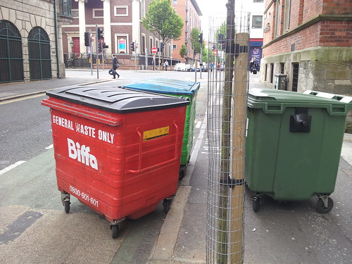
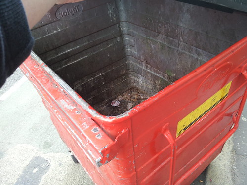
Recently, the Belfast bin lane (cycle lane on Upper Arthur Street) has seen the return of the red Biffa bin. Following contact with the company last September, partial success has been observed – it’s mostly been the Aisling award winning Wastebeater bins blocking the cycle lane of late.

Biffa’s explanation this time is that neither Biffa nor their client businesses are responsible for blocking the cycle lane. A mysterious unseen force is at work! Sensing Biffa trying to cover their behinds in the face of evidence showing blatant obstructions, NI Greenways allows poor Biffa enough rope to hang themselves..

– May 7 – (same morning)
Biffa

According to our Traffic Dispatcher at the depot, he has spoken with the driver who does this round. The driver has assured us that when he gets to the bin it is already in the cycle lane and after he empties it he sets it back against the wall. This afternoon our depot spoke to the manager of the Basement bar and explained the situation, he has told us that they always leave the bin up against the wall when they put it out in the morning. Given that both the manager of the bar and our driver are both insisting that they leave the bin against the wall, it must be being moved by a third party. If we could obtain CCTV we’d know for certain. Unfortunately, all we can do for now is move the bin back every time we discover it relocated. Happy to work with you if you have any other suggestions.

>>Bullshit alert!<<

– May 7 –
NI Greenways

Really appreciate you getting back so quickly.

Can I clarify exactly what you’re saying in your email, perhaps easiest if we refer to the attached picture?

Good, Bad or wee trap?

The Basement staff and Biffa staff are leaving the red Biffa bin by the wall (marked GOOD) but some unknown third party is moving them to the cycle lane (marked BAD, Wastebeater bin as example). Is this correct?

– May 7 –
Biffa

This appears to be the case. As I said, we are happy to work with you on a solution, if one can be found.

– May 8 –
NI Greenways

Thanks for the clarification. The solution is very obvious when we summarise the situation as you lay it out:

  • Basement staff are leaving the Biffa bin out for collection on the pavement, obstructing the public footpath
  • Some mysterious third party is then moving the bin to obstruct the cycle lane
  • Biffa staff collect the refuse and return the bin to its position obstructing the footpath
  • Again a third party then removes the bin to obstruct the cycle lane
  • Basement staff (at some point) take the bin back into the alleyway

So, whether or not some pesky unseen hand is taking the Biffa bin into the cycle lane, you’ve been very clear that both Basement staff and Biffa staff are placing the bin in a position which restricts pedestrian use of the footpath. If this is reported to Roads Service, the bin could be removed. This could leave the Basement liable to a return fee, and could jeopardise your client relationship. Never mind the grubby corporate image for Biffa of a branded bin blocking a city centre footpath/cycle lane and causing great inconvenience for wheelchair users among others.

You can see a few examples here, no doubt all caused by some third party:
http://www.flickr.com/groups/2191227@N22/pool/

The solution is very simple. Bins should be left at, and returned to, the alleyway. I look forward to your reply

– May 8 –
Biffa

Many thanks for your suggestion. I’ll speak to the depot and find out whether this is possible.  I imagine from our point of view, it makes no difference if the bin is located in the alleyway. However, I’m based in Birmingham and not familiar with this area. By leaving the bin in the alleyway it may be obstructing delivery/emergency vehicles or there may be some other reason. I’ll check with the depot and let you know.

– May 8 –
Biffa

I’ve spoken to the depot. They will ask the driver to pull the bin the 100 yards up the alley way back to the basement bar after it has been emptied. If its left in the entry to the alley way it’ll block access to a garage, which may explain the third party issue. Hopefully this will resolve the issue.

… … … … … … … … … … … … … … … … …

Give credit to Biffa for another speedy response and, at the point of complaint, a willingness to engage. Also thanks to DRD, who are keen to hear about bins blocking this cycle lane, and will happily remove offending items if reported.

The entry only being 30 yards long isn’t quite the chore it’s made out to be (and yes, even Google Maps Streetview loves a bit of bin lane blocking #facepalm). It’s also a daft suggestion that a bin set against a wall on a footpath would be moved by a car driver trying to get down the alleyway, but then the bin lane does have it’s own special rules and perhaps laws of physics, so anything’s possible.

Whether the spooky third party movement excuse was a spectacular porky or not, at least it cleared up that Biffa bins shouldn’t be blocking the pavement or the cycle lane. And they won’t be in the future. Will they? Oh Biffa..

– 3 June –

3 June 2013

Untitled

More bin lane love:

Report an obstruction on a footpath, cycle lane or road on the NI Direct site

Follow the latest blockages on the Belfast Bin Lane Flickr group (sad as it is)

Is it still the bin lane or is it the Ulster Bank delivery lane?

Lame attempt at bin lane humour

The North Down Coastal Path, and the surrounding local economy, is one major project away from fulfilling its tourism and leisure potential. A new high quality traffic-free link is needed to address the current disconnection from Belfast. This will integrate with the growing urban greenway network, encourage Belfast residents to visit North Down more regularly, and open up a new seam of tourism opportunities. Considering the current options for route development, an intriguing new greenway project is proposed.

Explore the Belfast urban greenways on Google Maps
Traffic-free network in Greater Belfast Area – disconnected from the North Down Coastal Path

.
The North Down Coastal Path begins at the north end of the George Best Belfast City Airport runway, with a gate to the road running past the Kinnegar Army base. From here, Belfast City Hall is 6.5km away with no direct traffic-free route. When the Connswater Community Greenway is completed as far as Victoria Park the shortest distance to this pathway network will be 4.5km, but accessible only by busy main roads.

This is a particular problem for leisure cycling; families with youngsters, inexperienced cyclists, tourists based in Belfast. These are already significant distances before the relaxed ‘leisure’ part begins, and poses a barrier to many people who would otherwise love to tootle along the coast for a day and spend in the local economy.

At present there are just two options available for travelling by road. Both routes are quite direct, but also have severe drawbacks for cycling and walking.

The A2 / Sydenham Bypass

The road ‘benefits’ from separate cycle tracks on both carriageways, but you’ll seldom see people choosing to take this route. This is quite a horrible place to be on a bicycle; a heavy traffic urban dual carriageway, with vehicles travelling above and below the 50mph speed limit.

An apparent lack of sweeping leaves the cycling surface strewn with road grit and glass. Not a happy start or end to a leisure trip, and not somewhere suitable for children or inexperienced riders to cycle. Great if you like cinematic thrills, but not fit for purpose as a modern cycle route.

Sydenham Bypass cycle lane, murderous traffic, puncture-friendly surface

It’s hard to imagine a country like the Netherlands, where road design is based on sustainable safety principles, funnelling cyclists into the hard shoulder of what is practically an urban motorway, then promoting it as an important link in the country’s cycle network.

Pedestrian access to the bypass is slightly easier with the footbridge at Sydenham Station and subway by Victoria Park, but the drawbacks of the traffic noise and fumes make this a less than appealing environment. Popular with joggers and power walkers, but lacking in great utility.

Future development of the road will include widening to three lanes each way. There will be just one 3.5m shared cycle/footway on the Victoria Park/Airport side – finally to include a physical barrier which should improve safety perception – but designing a mixed footpath on this fast cycling commuter route is a real backward step.

As the Sydenham Bypass reaches the Tillysburn Gyratory, it’ll be back to the current heady mix of footpaths, hard shoulders and crossing over fast slip roads. With no cycle lane up the slip road to Holywood Exchange, cyclists are encouraged to continue for another 2.6km on the dual carriageway into Holywood town, missing the first section of coastal path.

While it’s important to retain cycling and walking space in major road developments, this appears to be an ideal time to seek better accommodation for sustainable journeys on this corridor.

The Airport Road

Favoured by many cyclists at present, the Airport Road tracks the western side of George Best Belfast City Airport. By comparison with the Sydenham Bypass, the traffic flows are greatly reduced. Yet heavy goods vehicles and oil tankers dominate the road here, and again this poses a frightening dilemma for the novice cyclist. The pathways suffer from high kerbs and no dropped access at the many side roads; unsuitable for cycling, so the road is the only option at present.

There are plenty of opportunities on the countrybound side to reclaim space to develop a separate cycle track with the parallel pedestrian pavement. This is understood to be the preferred solution for a future cycling route, with a new bridge due to link Victoria Park with the Airport Road at the end of the Connswater Community Greenway.

Airport Road Belfast

Yet there is another issue which makes this route currently unattractive – the isolation. There is one way in and one way out, with some limited added value with the commuting link to the Bombardier site and businesses based in the Heron Road Complex. But workers here will tell you the dirt left by heavy construction traffic makes cycle commuting conditions less than ideal.

The Airport Road option also narrows the usefulness of the route to cyclists only. Very few ‘additional’ walking journeys would be generated along this stretch, being set so far away from residential areas.

But is there another way to accommodate sustainable transport in this part of the city, and link the greenway networks, away from the compromises of being tied to major roads?

A Sydenham Community Greenway?

Looking to the southeast side of the airport, across the A2 and railway line, there is another option worth exploring which ticks many more boxes:

  • direct route
  • traffic-free
  • space for full mode separation where needed
  • integration with rail network
  • greater number of access points
  • weaving through residential communities
  • integration with existing leisure facilities
  • new commuting and shopping access

Sydenham Community Greenway proposal section 1

Starting from the Connswater Community Greenway link to Victoria Park, this route would make use of Inverary Drive. This traffic-calmed and relaxed residential road is an ideal start, running for almost a full kilometre. There is an existing bridging pathway between Park Road and Inverary Drive which can be upgraded to greenway standard.

Inverary Drive pathway

Inverary Drive is a wide and calm street environment with very little through traffic. It’s possible to accomodate cycling on the road (with a 20mph limit) but space exists to provide a fully separate track by the railway fence for a ‘continuous’ route feel, and providing the highest safety standard to separate pedestrians, cyclists and other vehicles for this short stretch.

Inverary Drive

There is an important link with Sydenham railway station on this route, and a greenway route on the doorstep opens this station up as a jumping off point for journeys towards the Connswater/Comber corridor, and north where we’re headed.

Continuing on, the road turns east into Inverary Avenue at the Inverary Community Centre, but this proposal would run a traffic-free path behind the centre and through Alderman Tommy Patton Memorial Park. This popular urban park has recently upgraded its play facilities, and is another lesser-known gem in Belfast. Passing by the football pitches, the new path would approach a patch of woodland. There is an existing looped forest pathway which runs along the boundary with the train line; this could be carefully and respectfully upgraded for the purposes of a continuous greenway route.

Alderman Tommy Patton Memorial Park woodland path

Viewed from the woodland path, the potential local benefits of the next section start to snowball – the main terminal of George Best Belfast City Airport is but a stone’s throw away. The greenway would continue to follow the line of the railway fence, across the back of Shorts Recreation Club and Blanchflower Park.

George Best Belfast City Airport

As with Alderman Tommy Patton Memorial Park, there appears to be ample space to set the railway fence back closer to the line if it’s necessary to accommodate the path away from the existing parks. But for the whole route to be viable, one piece of major engineering is needed at this point.

SydBridge
A very poor artist’s impression of a standalone bridge

The most direct route to Holywood requires the path to cross over the railway lines opposite the airport. There are two options here:

  • a standalone bridge crossing diagonally to meet the airport exit road
  • a looped ‘S’ bend crossing over the railway tunnel at the Sydenham Bypass and turning again into the airport exit tunnel

George Best Belfast City Airport Access Underpass

A simple upgrade of the airport access tunnel can continue the route towards Holywood Exchange. The tunnel already has a wide footpath and cycle lane marked on the road. Providing kerb separation at the exiting cycle line would allow 2-way cycling and walking without affecting airport traffic. There is a further option to drop an access path from the countrybound Sydenham Bypass, allowing direct cycling and walking access from the Tillysburn cycling underpass and linking the communities around Knocknagoney Park.

Sydenham Community Greenway proposal section 2

The City Airport site employees around 1,500 people, with many workers travelling from East Belfast with little option but to drive. This new greenway option opens up a significant swathe of Belfast to a truly viable alternative to car travel. And if you think the suggestion of cycling to an airport for onward travel is daft, this isn’t the case at other airports around the world, even including many served by George Best Belfast City Airport flights.

Holywood Exchange abandoned access road behind IKEA

The roundabout at the airport tunnel leads off to an abandoned access road. Today this is used for fly tipping and is a favourite spot for taxis wanting to beat the waiting restrictions within the airport car parks. This is ripe for conversion to a walking and cycling-only route into the Harbour Estate at Holywood Exchange as part of the greenway. The proposed path would cut left alongside the airport boundary fence and into the retail complex at IKEA’s massive sign. There is already a natural land buffer between the airport boundary fence and Airport Road West, ripe for a separate cycle track all the way to the North Down Coastal Path.

IKEA sign at the George Best Belfast City Airport boundary fence

Hundreds more local workers travel to the large businesses situated here: IKEA, Decathlon, B&Q, Sainsburys, Next, BHS, Harvey Norman. Commuting options are increased for locals, but also new options for shopping trips..

Cough cough .. stop right there! Shopping at IKEA? By bike?!

If the idea of cycling to IKEA to go shopping seems even more daft than the airport link, it’s perfectly obvious, natural and not uncommon in other countries. The difference between a city like Copenhagen and Belfast is exactly the type of traffic-free infrastructure being proposed here.

geograph-1274238-by-Rossographer

The separate cycle pathway would continue along the airport boundary fence until passing out of the Holywood Exchange complex, before turning under the flight path at the end of the runway. This is another one of those little treasures of Belfast – standing under a landing aircraft seemingly at touching distance.

Getting from the airport side to the Kinnegar gates requires a road crossing – the only one on this entire 4km route. The bulk of traffic on the road only goes as far as the retail park, so a pelican crossing  beyond B&Q could be an appropriate solution. Once the confusing access issues with the Habour Tillysburn gates are ironed out, a continuous link to the North Down Coastal Path is now achieved.

Local value of a long-distance greenway

Running the connecting greenway through a residential community rather than the Airport Road must be carefully weighed. The main local benefit would be the potential displacement of some regular private car journeys to cycling and walking.

The 3 wards surrounding this proposed route, Sydenham, Island and Belmont, have just over 16,000 residents. Census figures bear out that these ‘greenway wards’ are not much different from the rest of Belfast; just shy of a quarter of all commuting journeys are under 2km (1.2 miles) and nearly two thirds within 5km (3 miles) range. Yet motorised trips are higher here at 56% (48% all Belfast) and walking journeys lower at 17% (22% all Belfast). One third of households in the greenway wards have no access to a car, which is a high figure in itself, but less than the Belfast average (40%), so the area is possibly more car dependant that it needs to be.

Alderman Tommy Patton Memorial Park entrance path
Alderman Tommy Patton Memorial Park linking greenway trips to Ashfield High Schools?

While the footprint of the proposed greenway is on the periphery of the residential area in these wards, it would still open up new linkages into the harbour estate and enhanced traffic-free sections for many parents and children on the school run to Victoria Park Primary School, Ashfield High Schools and Sandbrook Nursery School.

A potential new community greenway for Belfast, linking the city with the North Down Coastal Path, providing viable commuting, shopping and leisure alternatives to private car travel. On the face of it would seem a very cost-effective option should Belfast City Council, Northern Ireland Government departments, Sustrans or others wish to take it forward with a feasibility study. With just a few wrinkles to be ironed out on access, this would seem to provide excellent value for money – a 4km Sydenham Community Greenway as the final piece of a fully connected Belfast Metropolitan Area greenway network. Is it possible?

The North Down Coastal Path remains a gem in Northern Ireland’s tourist and leisure offering. The section from Holywood to Bangor stretches 10 miles along rocky shores, fine sandy beaches, quiet coves, country parkland, busy promenades and moments of perfect isolation. This post celebrates the importance of the North Down Coastal Path, and looks at the work ahead to release its full potential.

© Copyright Michael Parry and licensed for reuse under Creative Commons Licence

As a kid growing up in Troubles Belfast, there was always a little bit of magic about day trips to North Down. Whether it was the chocolate box train stations, the many fun activities, or just the sharp change of scenery just minutes out of the city, it was an easy place to fall in love with. Finding out that there was a ‘secret path’ that went for miles around the coast added to the mystique. It later became a favourite adventure to cycle* from Belfast to Bangor and back.

Explore the North Down Coastal Path on Google Maps

The attraction of the Coastal Path today is just as great. Starting on the Belfast side, the path begins around Holywood, starting its close relationship with both the sea and the railway as it passes close to Holywood Station. There are 8 railway stations from Holywood to Bangor and most are with 500m of the Coastal Path, making short trip options wonderfully flexible. The section at Seapark, according a recent tendering process, will shortly be upgraded to enhance walking and cycling* access. Striking out from the urban environment the path passes playgrounds and millionaires’ retreats, mixing shared footpaths with residential roads.

Ross [CC-BY-SA-2.0 (http://creativecommons.org/licenses/by-sa/2.0)], via Wikimedia Commons

The first stop of major interest is at Cultra. The Ulster Folk and Transport Museum covers a large area on both sides of the busy A2 road, and the two sites have enough of interest for a day trip each. These museums cover a vast timeline of Irish cultural and engineering history. Unfortunately there is no direct access from the Coastal Path into the Transport Museum site, with a long trip up the nearby Glen Road and back down to the main entrance the only option.

Onwards to Station Road, marking the end of the residential sections of the route, and a fierce contrast to the smooth promenades and streets so far. Crossing the boundary of the Royal Belfast Golf Club, a tight mud/gravel path clings to the shoreline, between crass fencing and artificial sea defences.

© Copyright Eric Jones and licensed for reuse under Creative Commons Licence

Some sections near here are due for upgrade, but a comprehensive look at improvements to weak links in the chain is necessary. Comments on Twitter suggest commuters to Belfast from Seahill and further would benefit from a realistic option to cycle* somewhere other than the main A2. Improvement works have been seen in recent years, especially as we move on past the Rockport School.

© Copyright Eric Jones and licensed for reuse under Creative Commons Licence

Approaching Seahill there is a rocky inlet which is traversed by two flights of steps and a high narrow path. This effectively cuts the Coastal Path in half for wheelchair users and anyone pushing a bicycle* who may be unable to lift and carry a bike up and down the narrow flights.

© Copyright Albert Bridge and licensed for reuse under Creative Commons Licence

North Down Borough Council have been working with the Northern Ireland Environment Agency to provide a sustainable and environmentally acceptable alternative. This is currently planned to be a boardwalk, level with the rest of the path. Once completed this will boost the potential of the entire route.

A leisurely stretch brings us to Helen’s Bay, and as the path turns southeast towards Bangor, the Grey Point Fort dominates the headland. Sighting Scotland for the first time, a steep climb and a quick nip onto the local road finds us dandering down towards Crawfordsburn Country Park.

© Copyright Albert Bridge and licensed for reuse under Creative Commons Licence

On sunny summer days the beach and surrounding fields come alive with day trippers tucking into picnics and the sounds of delighted kids. Secluded woodland walks, waterfalls and spectacular railways arches lie in wait away from coastline. In days gone past the railway halt at Crawfordsburn allowed day trippers the option of a train directly to the beach path. Today the Helen’s Bay Station is still close, but the vast majority of visitors to Crawfordsburn Country Park still arrive by private vehicle.

© Copyright Kenneth Allen and licensed for reuse under Creative Commons Licence

Passing the impressive Crawford House complex (read more about the history of Crawfordsburn Park on the Lord Belmont in Northern Ireland website), wide promenades have taken us across two beaches. Reaching Swineley Bay, the path stops abruptly and it’s a dander over the sand to the other side of the beach. Not too much of a problem for ramblers, joggers and dog walkers, but another difficulty for anyone with self-propelled transport*.

© Copyright Eric Jones and licensed for reuse under Creative Commons Licence

The Coastal Path and railway line finish their game of hide and seek as the outskirts of Bangor are reached at Carnalea Golf Club. Leaving sandy beaches behind for more rocky shores, the path twists and undulates towards Smelt Mill Bay, naturally regulating any speeding wheels*. Turning round to face Bangor Marina, the Pickie Pool may no longer stand proud on this side of town, but today’s Pickie Fun Park shows how investment in new facilities can reap great rewards for a local economy.

© Copyright Rossographer and licensed for reuse under Creative Commons Licence

Tourism has influenced the development of Bangor since Victorian times, and although slow to respond to the changing holiday habits from the 1960s onwards, the town is beginning to thrive on smart investments such as the Marina complex and integrated transport hub. The North Down Coastal Path may be a small part of the overall package for Bangor, but with Belfast just a couple of leisurely hours away by bike* and tourism becoming more important to Northern Ireland as whole, the North Down Coastal Path should be given greater marketing prominence as a high quality active travel corridor.

To cycle* or not?

Two issues seem to dominate discussion of shared paths like this one, dogs and cyclists. It may come as a surprise how the the issue of cycling has been settled – North Down Borough Council by-laws prohibit cycling on any part of the North Down Coastal Path. Hence the coy cycling* references earlier!

Councillors are actively working on solving this problem, now widely recognised as outdated and largely unenforced in practice. In fact, Council cycling information signs are common along the route, and leaflets on the North Down Borough Council website even promote Sustrans’ National Cycle Network as running on sections of the path.

While mixing cyclists with ramblers can be difficult, the North Down Coastal Path for the most part naturally calms the top speed of leisure cyclists – either by tight twisting passages or the relentless glorious scenery to be savoured. This is not a welcome nor coveted environment for faster road cyclists or Strava junkies, especially as many sections are still suitable for a mountain bike only.

There is perhaps a more fundamental tension at work here between the interests of local users and those wishing to develop a route capable of attracting and handling higher usage. The same complaints play out on the Lagan Towpath and Comber Greenway, but everyone must face the reality that these routes are being developing as mixed use to maximise the numbers and range of users.

Consideration and respect is necessary for a harmonious environment; prohibition is a blunt instrument which isn’t working and holds the path back. The local economy can only benefit from increased usage of the path by day tripping cyclists from Belfast, whether resident or tourist.

Tillysburn gates confusion

Getting to the North Down Coastal Path from the Belfast side is challenging, and there is a need for a new traffic-free route into Belfast. From The Esplanade in Holywood there is a quiet coastal road which leads to the entrance of the Belfast Harbour Estate at the end of the George Best Belfast City Airport runway. The road is private, owned by the Ministry of Defence as part of the Kinnegar Barracks, yet walking and cycling is so common and accepted that the gates onto the Harbour Estate are now permanently open.

Kinnegar Gates

This is very welcome for local users but is only one hurdle to a continuous, fully accessible greenway route. Just 100m from this opening are the Tillysburn Harbour Gates, operated by the Belfast Harbour Police.

A sign here suggests overnight closures during the week and shut gates all day Sunday. In conversation with the Harbour Police, these hours were confirmed as open from 6.30am Mon-Sat, closed around 11pm each weekday, causing few problems for commuting and leisure. But the Sunday closure was also confirmed, with the gates locked at 7pm on Saturday night and not opening again until Monday morning – prime time for leisure use.

Tillysburn Gates

To make sure of the situation, I took trip down and observed wide open gates at 12pm on Sunday 21st April, obviously contradicting the only publicly available sources of advice. No accurate information available on the Belfast Harbour website at the time of writing.

It’s a confusing situation for everyone – the very existence of a barrier shown as closed on Google Maps creates uncertainty – and clarity is required. In the first instance the Harbour website needs to be regularly updated with access hours, allowing all the relevant tourism sites to reflect the latest info. In the medium term, a more permanent arrangement for a continuous pathway makes more sense.

This could be achieved either by setting the whole security barrier back by 150m to give a clear route through to Kinnegar, or developing a separate ‘greenway’ path away from the road near to the edge of the lagoon. With the main A2 road unappealing for leisure cycling or rambling, making full use of this section for sustainable travel is essential for the future of the North Down Coastal Path.

For more on the North Down Coastal Path and opening a quality link to Belfast read part two on the Belfast to Bangor Greenway: the final link.

Many thanks for input on both posts from the following Twitter bods: @_Helmholtz_ @BrianLatewood @chasingsilver1 @oceanbump @chris0ward @RichardJeffrey1 @AndrewMuirNI @StripyMoggie @andyboal @10ON12 @collapsibubble @ye_Bhoy_ye @rinkyrinky 

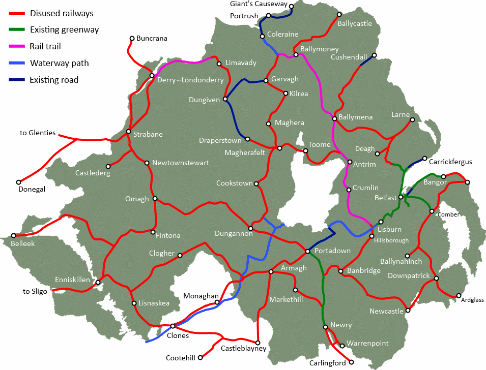
Leisure and tourism in County Tyrone could be boosted by reopening a former railway line as a cycling and walking route. The Great Northern Railway branch line ran from Cookstown, through Coalisland and into Dungannon. Built in 1879, fully enclosing the Lough Neagh basin with railway lines, this branch was closed in 1959.  Creating a new Greenway for walkers and cyclists, local ramblers and active tourists, can create new economic possibilities and health benefits in the region.

Continue reading “Cookstown to Dungannon Greenway”

The towns of Cookstown, Moneymore and Magherafelt were once linked by a railway that now lies derelict. The old line, which winds through the Mid Ulster countryside, could be regenerated to provide a high quality 11 mile walking path and cycle route. This could be an important part of an orbital pathway around Lough Neagh, and a key tourist route west of the Bann.

CookstownMagherafelt

Continue reading “Cookstown to Magherafelt Greenway”

Nestled between the River Bann and the Sperrins, a disused railway line snakes between the towns of Magherafelt, Maghera, Kilrea and Garvagh. The line was built and operated as the Derry Central line, which fully closed in 1959. The route is still visible today, and presents an opportunity for regeneration. A new cycling and walking path, or Greenway, could be opened on the former trackbed, providing a healthy infrastructure for the Mid Ulster area and a boost to tourism.

MagherafeltGarvagh


Continue reading “Magherafelt to Garvagh Greenways”