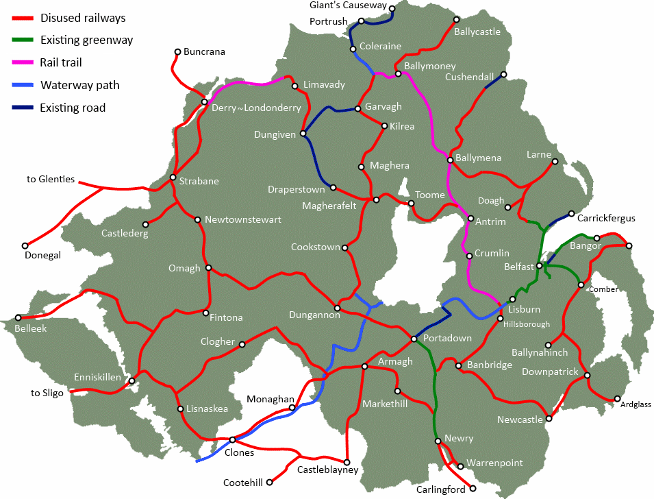
Nestled between the River Bann and the Sperrins, a disused railway line snakes between the towns of Magherafelt, Maghera, Kilrea and Garvagh. The line was built and operated as the Derry Central line, which fully closed in 1959. The route is still visible today, and presents an opportunity for regeneration. A new cycling and walking path, or Greenway, could be opened on the former trackbed, providing a healthy infrastructure for the Mid Ulster area and a boost to tourism.

Cycling and walking route through Mid Ulster
[googlemaps http://maps.google.co.uk/maps/ms?msa=0&msid=202802535379582075161.0004c023b517467d1fc00&hl=en&ie=UTF8&t=p&ll=54.877397,-6.619263&spn=0.355542,0.274658&z=10&output=embed&w=600&h=380]
Magherafelt is the crossroad for a proposed new traffic-free pathway network in the centre of Northern Ireland. With potential quality links to Draperstown and on into the Sperrins, south to Cookstown and east to Toome, the area could benefit greatly from increased tourist activity. To the north, a disused railway line winds its way towards the Causeway Coast.
Magherafelt to Maghera Greenway
The route begins behind the Mid Ulster Hospital, giving great leisure access to the many people using the facility each day. At the Ballyheifer Road, the Greenway would fork giving the option of a 2.5 mile trip to Desertmartin on the Draperstown Greenway. We head north, passing under road bridges still in use today, and crossing the Moyola River and tributaries. The farming land in the area is spectacular, and yet for the majority of this section the footprint of the former line has not been reclaimed for agricultural use.
The route turns northwest as it meets the Glenshane Road, and on the approach to Maghera. Lack of satellite imagery at this point makes mapping the entry into Maghera difficult. Former railway land in Maghera is visible today across from Station Road, and providing a traffic-free path through the town would be of great benefit to the community. The proposed cycle and walking path from Magherafelt to Maghera is just over 6 miles in length, connecting communities, allowing safe family leisure trips and encouraging local tourism.
[googlemaps http://maps.google.co.uk/maps/ms?msa=0&msid=202802535379582075161.0004c023b517467d1fc00&hl=en&ie=UTF8&t=h&layer=c&panoid=4HEckfkkxNpH64DlSo6zJA&cbll=54.782486,-6.624897&cbp=13,324.31,,0,15.81&source=embed&ll=54.71411,-6.624756&spn=0.237986,0.823975&z=10&output=svembed&w=600&h=300]
Maghera to Kilrea Greenway
Leaving Maghera, the cycle and walking path heads 2.5 miles to Upperlands. Satellite imagery shows the trackbed remains almost fully intact at this stage. Slight diversions seem possible to allow a linear route through Upperlands. The trackbed is mostly intact towards Tamlaght, with some residential and agricultural development encroaching on the route; however diversions onto the Kilrea Road may be possible.
Continuing north through the beautiful Bann Valley countryside, the line approaches Kilrea to the west of Kilrea Golf Club before turning to cross the Drumagarner Road south of the town. The total distance from Maghera to Kilrea is 9 miles, providing a wonderful facility for day trips and healthy leisure options. A Greenway in Kilrea would run close to the River Bann navigation, providing opportunities for leisure boat stay-overs to use the town as a base to explore the area on bicycle.
[googlemaps http://maps.google.co.uk/maps/ms?msa=0&msid=202802535379582075161.0004c023b517467d1fc00&hl=en&ie=UTF8&t=h&layer=c&panoid=fiX4x9PgR43nKEPkqJwHrw&cbll=54.886134,-6.613867&cbp=13,340.04,,0,5.67&source=embed&ll=54.817898,-6.61377&spn=0.237377,0.823975&z=10&output=svembed&w=600&h=300]
Kilrea to Garvagh Greenway
A Greenway running from Kilrea to Garvagh would be a quality 5.5 mile traffic-free cycle and walking path, linking two rural communities. The former railway line avoids the town centre due to the hilly terrain. Turning west from the former railway station at Drumagarner Road, the route crosses the Beechgrove development; a slight diversion could maintain a linear path and provide an important link route to Kilrea town centre. Continuing on through mixed land, some developed but mostly untouched, the route encounters the Edenbane Road. A new dedicated shared cycle and pedestrian path can be developed on this wide road, which has an existing pathway.
After 1 mile, the route heads northwest into the countryside, crossing and following the line of the Killyvally Road, before approaching Garvagh at the Carrowreagh Road. Here the line turns towards Ballymoney, but an upgrade of the Carrowreagh Road to prove cycling and walking access to Garvagh is required. A cross-town path to link with Garvagh Forest would have obvious leisure touring benefits.
[googlemaps http://maps.google.co.uk/maps/ms?msa=0&msid=202802535379582075161.0004c023b517467d1fc00&hl=en&ie=UTF8&t=h&layer=c&panoid=uGLj0EoVik1gxvQbLA31Eg&cbll=54.975006,-6.644043&cbp=13,270.06,,0,4.24&source=embed&ll=54.907212,-6.643982&spn=0.236851,0.823975&z=10&output=svembed&w=600&h=300]
Three possible Greenway routes linking Magherafelt, Maghera, Kilrea and Garvagh could bring great benefit to the local economy, local community connections and health of the population. Almost 21 miles of mostly undeveloped trackbed is a golden opportunity to regenerate our industrial and engineering heritage, and provide a new healthy infrastructure. If developed as part of the fuller Northern Ireland Greenways network, with over 600 miles of segregated pedestrian and cycling paths, the area would be linked to the Causeway Coast via Ballymoney and Coleraine, Belfast via Antrim, and into the west via Cookstown.