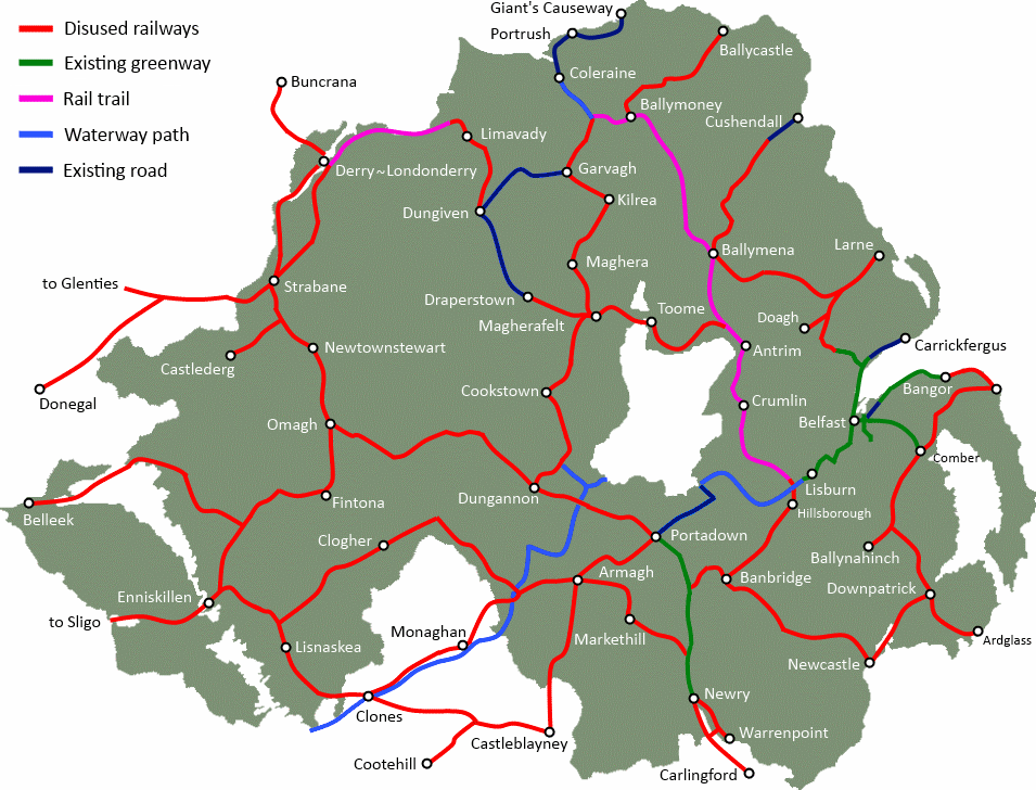
Leisure and tourism in County Tyrone could be boosted by reopening a former railway line as a cycling and walking route. The Great Northern Railway branch line ran from Cookstown, through Coalisland and into Dungannon. Built in 1879, fully enclosing the Lough Neagh basin with railway lines, this branch was closed in 1959. Creating a new Greenway for walkers and cyclists, local ramblers and active tourists, can create new economic possibilities and health benefits in the region.
[googlemaps https://maps.google.co.uk/maps/ms?msa=0&msid=202802535379582075161.0004c0a7236ea94204650&hl=en&ie=UTF8&t=p&ll=54.573256,-6.736679&spn=0.167169,0.411987&z=11&output=embed&w=600&h=420]
Note to readers: click to open a larger map, then select ‘Satellite’ to trace the route as it is today
Cookstown to Coalisland Greenway
The first section of Greenway covers a distance of 9 miles from Cookstown to Coalisland. The line begins at the intersection of two railways in Cookstown, with the former Belfast and Ballymena Railways line also being proposed to be reopened as the Cookstown to Magherafelt Greenway. Locals in Cookstown will be aware of the Great Northern Railway arch beside the Cookstown Hockey Club. Turning south out of the town, the line passes by the Cookstown Vion factory, and the eastern boundary of the Killymoon Golf Club.
Poplar Hill Road railway bridge
[googlemaps https://maps.google.co.uk/maps/ms?msa=0&msid=202802535379582075161.0004c0a7236ea94204650&hl=en&ie=UTF8&t=h&layer=c&panoid=MVSNI6IZX1Za6MusTF6FXw&cbll=54.615719,-6.711275&cbp=13,331,,0,10.03&source=embed&ll=54.581514,-6.711273&spn=0.119382,0.411987&z=11&output=svembed&w=600&h=300]
The route passes across farming country, however as seen from satellite imagery, approximately 60% of the line remains untouched by agriculture. A number of properties have been built on or beside the former line, so minor diversions would be required for a fully continuous route. The route passes through mixed surroundings, farming land, small townlands, woodland sections, some high embankments and sections with cuttings and overhead road bridges.
Sessiagh Road railway bridge
[googlemaps https://maps.google.co.uk/maps/ms?msa=0&msid=202802535379582075161.0004c0a7236ea94204650&hl=en&ie=UTF8&t=h&layer=c&panoid=LuHxhPpkJwVDA08yk38nVA&cbll=54.610495,-6.708914&cbp=13,179.72,,0,4.83&source=embed&ll=54.570967,-6.709213&spn=0.139316,0.411987&z=11&output=svembed&w=600&h=350]
Continuing through beautiful the County Tyrone countryside, the Greenway would turn east towards Stewartstown. The local population would greatly benefit from a traffic-free pathway linking to Cookstown (6 miles), Coalisland (3 miles) and on to Dungannon. Some short private car journeys could be replaced by cycling, or a dander into Coalisland and back. The line continues south approaching Kileen and the closest point to Lough Neagh, with possibilities for a link to the shore to enhance tourism options. Turning west and with minor diversions the route enters Coalisland town.
Derelict railway bridge and embankment Coalisland
[googlemaps https://maps.google.co.uk/maps/ms?msa=0&msid=202802535379582075161.0004c0a7236ea94204650&hl=en&ie=UTF8&t=h&layer=c&panoid=jXi5n6BgORlVylERJ72QfA&cbll=54.544618,-6.700652&cbp=13,199.04,,0,2.1&source=embed&ll=54.51022,-6.700974&spn=0.119591,0.411987&z=11&output=svembed&w=600&h=300]
Coalisland cycling and walking provision
Coalisland and the surrounding region benefits from a good leisure infrastructure. The Coalisland Canal and River Blackwater were former economic corridors in the region, and though derelict for decades, recent interest and community involvement has seen wonderful redevelopment. The Coalisland Branch of the Inland Waterways Association of Ireland have seen effort and hard work pay off with the opening of the Coalisland Canal Walk, a 5 mile path along the canal. The River Blackwater also benefits from a 20km canoe trail, adding to the active tourism attraction of the region.
Coalisland to Dungannon Greenway
A proposed Greenway from Coalisland to Dungannon would cover 5 miles, linking these towns with a viable alternative to local private car travel. Traces of the former trackbed have been virtually erased south of the Cookstown Enterprise Centre, but it becomes visible again past the Dungannon and Bush roads. The line follows the contours of the local countryside to produce a series of ‘S’ shapes, making for a very attractive route.
Former railway line turning away from Mullaghmarget Road
[googlemaps https://maps.google.co.uk/maps/ms?msa=0&msid=202802535379582075161.0004c0a7236ea94204650&hl=en&ie=UTF8&t=h&layer=c&panoid=wBxjqjDU11dB1HoK1GxE1w&cbll=54.523762,-6.723047&cbp=13,79.83,,1,1.95&source=embed&ll=54.489486,-6.722946&spn=0.119652,0.411987&z=11&output=svembed&w=600&h=300]
There is limited agricultural development on this section of potential Greenway, and few properties affected. Past the Killymeal Road, half a mile of the railway route has been used for the A45 road. The road section is wide enough to consider installation of a dedicated cycle and walking path to enable continuity in the route. On approach to Dungannon the former line crosses the Edendork GAC ground and along the boundary of the Tyrone Brick site. Consideration on the best way to divert around these developments would be required, however there are obvious benefits to a traffic-free link from Dungannon town centre to a major sports facility.
Turning past Dungannon Golf Club and residential developments on the Pomeroy Road, the proposed route reaches the current 1 mile pathway developed on the former Dungannon Railway station site. This site shows the potential of leisure space for local communities, and could serve as the bridge between cycle touring journeys north to Cookstown, west to Omagh and east to Armagh.
Greenway benefits to Cookstown, Coalisland and Dungannon
Opening the former railway route from Cookstown to Dungannon as part of a wider Northern Ireland Greenways network has great economic potential. Northern Ireland has a major obesity problem, and providing open access to countryside leisure space, and active travel options for short journeys, can lead to better health outcomes in the future. Local leisure travel can be a good way to access shops, cafes and restaurants without adding to local congestion and parking issues.
A larger network of cycle and rambling pathways can bring active tourists into the area, potentially offering a regenerated local tourism and hospitality sector to thrive. County Tyrone has a wonderful piece of engineering and industrial heritage sitting idle – creating a 14 mile Greenway here could make a big difference to the local community now and for future generations.
You can read more information on the history of railways around Lough Neagh on the Lough Neagh Heritage website.