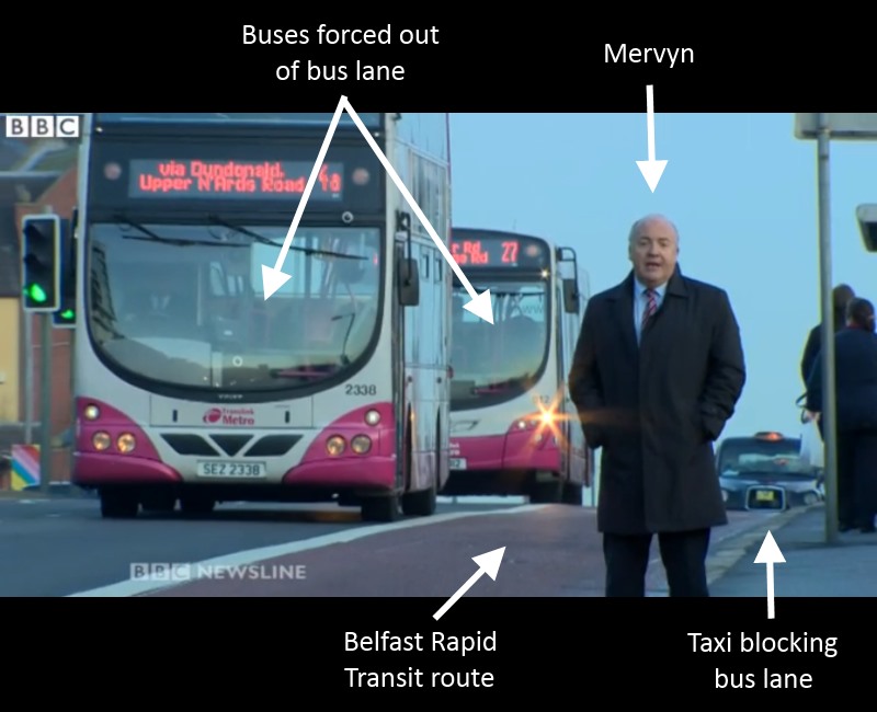
Residents in Belfast’s Short Strand have campaigned for years to calm the traffic on Mountpottinger Road, a key rat run for traffic using the city’s Cross Harbour M3 Motorway. A recent £275,000 road upgrade promised improvements for pedestrians, but the resurfacing scheme appears to have made the traffic situation worse. It’s time to remove all through-traffic to allow families and children to reclaim Short Strand’s streets before the shocking level of HGV traffic, which ignores a more suitable bypass, causes a major tragedy.

The Bull Run

The Short Strand community in East Belfast should be a very quiet residential area, free from traffic concerns. Due to the legacy of The Troubles it is penned in by Peace Walls, with just 3 road gateways – Bryson Street, and at either end of the main spine through Mountpottinger Road and Link.

Titanic Quarter and the M3 Motorway (the key strategic traffic corridor in central Belfast serving the Westlink, M1 and M2) sit to the north, and directly to the south a huge junction links the Ravenhill, Woodstock and Cregagh, Castlereagh, Albertbridge Roads, as well as one of just three bridges linking East Belfast to the City Centre, the Albert Bridge.


ShortStrandOverview


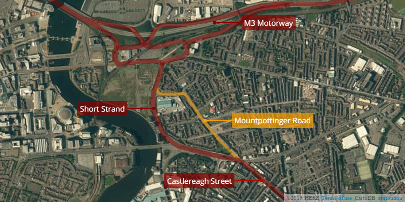
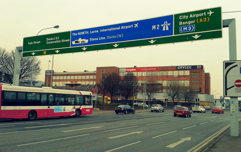
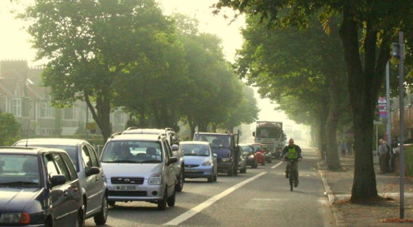
The four-lane Short Strand bypass should be the most preferable route for journeys between the M3 and Castlereagh Street, however a significant volume of general traffic cuts through Mountpottinger Road – most obvious at evening rush hour with long southbound tailbacks.

How bad is the situation for this otherwise sleepy residential area? Here’s a condensed 35 minutes of footage during a Friday rush hour (just after 9am) which shows the scale of the problem:


That’s 37 trucks and HGVs passing through (more than one every minute), white van man filling his boots with 41 commercial vans passing through, and an overall traffic level of around 500 vehicles per hour. The vast majority of vehicles simply enter at one end of Mountpottinger and leave at the other.

The Department for Regional Development (DRD) was at pains during the traffic reduction scheme in Belfast City Centre – Belfast on the Move – to distinguish between vehicles which had a purpose and destination in the area and those which had “no business there”. There is no more apt description for what’s happening on Mountpottinger Road. To label it a rat run perhaps minimises the scale of the problem.

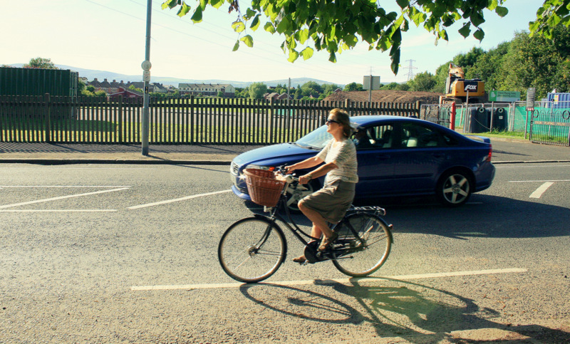
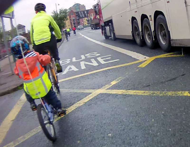
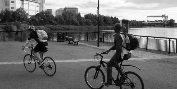
The nature of these streets is very different to most of inner city Belfast. Children ride bicycles and scooters along and across Mountpottinger Road; they cross from the play-park to the shops; they roam care-free in the shadow of a constant stream of through-traffic. Collisions have occurred in the past and because of how this road is being used (or abused) a tragedy lies in wait for a local family in the future.


Why do drivers cut through Mountpottinger Road?

On the surface it seems strange that drivers wouldn’t use the route around Short Strand – marked in red on the map above – it’s wider, has more capacity, feels ‘faster’, and has no house frontages and very little pedestrian footfall. However some quite obvious and more subtle factors are at work which make Mountpottinger an attractive choice.

Northbound

Arriving at the Castlereagh Street junction with the Albertbridge Road, drivers are faced with a problem. The route around Short Strand involves a left turn, however the view is obscured by Bank House. Drivers can’t calculate possible hold-ups due to the volume of traffic (which can be at a standstill during rush hour) or if the lights at the Woodstock Link junction will catch them – the first of three potential red lights.

Ahead lies a wide opening to Mountpottinger Road – almost never congested heading north – and the subtle influence of being able to see buildings and hills in North Belfast.


Castlereagh_view


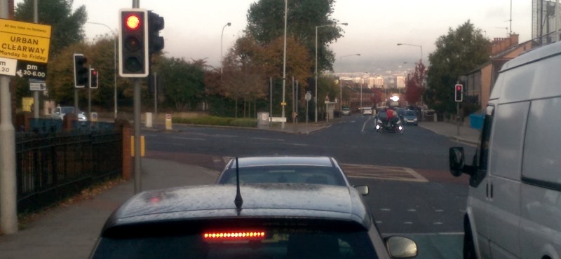
All the way down Castlereagh Street to this point, HGV drivers have seen the variable speed signs on the M3 Bridge peeking over the tops of the houses in Short Strand. Your destination is straight ahead, while an uncertain gamble lies to your left.

Southbound

There is less of a visual incentive to rat run when heading south, with the sweep left towards the Ravenhill junction inviting you to carry on past the immediate turn into Mountpottinger Link. Yet during the evening rush especially, stationary traffic around the Bridge End gyratory has already frustrated many drivers.


Ignoring the rat run takes you to a filter lane which has a triple whammy of frustration for impatient drivers – a signalled pedestrian crossing, an unsignalled exit and even a cycle lane to worry about – all of which means guaranteed congestion at rush hour. After that, another set of lights has to be negotiated at Woodstock Link, and the difficult-to-reach right filter lane for Castlereagh Street has a fast light sequence which can lead to long queues and delays.

Overall, both north and south routes though Mountpottinger involve just two sets of lights – one of which is an infrequently used toucan crossing – and a good chance of a beating queues. The more appropriate bypass has three signal-controlled junctions, three chances to hit a queue, and also means mixing with ‘strategic traffic’ funnelling through a mega-junction with multiple destinations.

The Mountpottinger rat run is a gamble with extremely favourable odds at rush hour, and no worse than evens at any other time.


Radical intervention

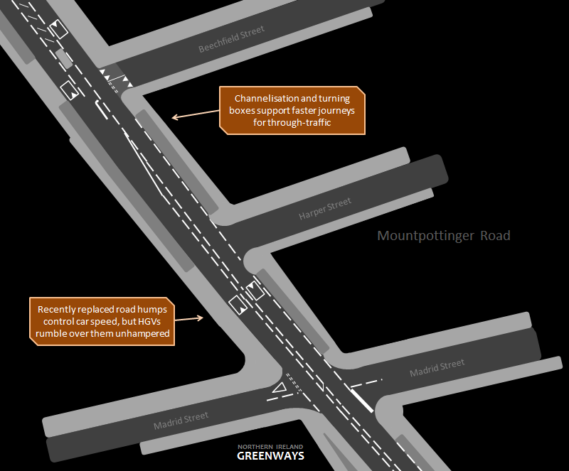
Local residents’ campaigning for traffic calming measures recently seemed to pay off. Road humps have been a feature for many years, yet these have failed to tackle the underlying issue. When a road re-surfacing scheme was announced for 2013-14, it was a chance to give serious thought to reducing the attractiveness of Mountpottinger Road to through-traffic. The main change was a puffin crossing at the play park beside The Strand Bar, widely welcomed as bringing “benefits for all road users and pedestrians in the local area.

However, the enhanced channelisation of the road – providing a central hatched area to create turning boxes for vehicles – was a clue that the needs of vehicle movement and safety was being elevated above the need to reduce traffic volume and speed. Channelisation simply allows vehicles to smoothly travel past stationary vehicles waiting to turn right which might otherwise halt traffic flow. Instead of making Mountpottinger Road a quiet street where people could cross anywhere, installing a puffin crossing was an admission of defeat – we can’t do anything about the flood of traffic, so here’s one good crossing point.


And the overall result of the road improvements? Residents will tell you the traffic levels are as bad as ever, and HGVs rattle through all day every day, hardly noticing the road humps as they heave their loads.

The problem is DRD didn’t proceed with an explicit aim to remove through-traffic – instead it ended up aiding and accelerating the typical through-journey, skewing the risk/reward balance in favour of rat-running.

https://twitter.com/OnTheFence22/status/618683697928249344

What is required now is a far more radical intervention, with the sole aim of displacing strategic through-traffic back onto the strategic route around the area and reclaiming the streets for local residents, families and children. A 20mph zone should be introduced tomorrow, but physical changes to the streets are badly needed.

My preferred street redesign (intended to kick off discussion) is based on three key principles:

  1. Remove *all through-traffic (see 2)
  2. Retain the Metro 5A bus service through Mountpottinger Road
  3. Provide a design solution with the least inconvenience to local vehicle movements


Dissuasion at the entrances

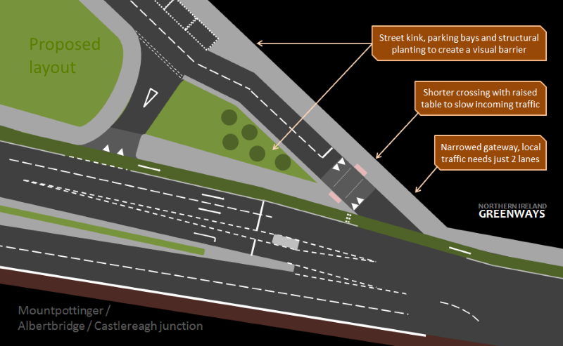
The visual attraction to straight-ahead rat-running from the Castlereagh Street junction must be eliminated. To begin with, any scheme intending to reduce traffic levels on Mountpottinger Road will mean two exit lanes will be unnecessary, so the road should be tightened to one lane in, one lane out.


Albertbridge_Junction_1


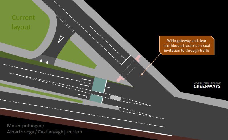
Shifting the ‘entrance lane’ over to the right will break up the visual invitation to fly straight ahead, and some structural planting, trees etc. will add to the feeling of a barrier. However the goal is not to close the entrance – so as to inconvenience local residents – but to plant a seed in drivers’ minds that this is a residential street, not a ‘main road’. Earlier signage on Castlereagh Street can flag up ‘No through road’ or ‘Unsuitable for HGVs’ to further dissuade use.


Albertbridge_Junction_2


At the Mountpottinger Link end, the sweeping filter lane allows HGVs to trundle through at speed, again tipping the risk/reward balance towards rat-running.


Short_Strand_1


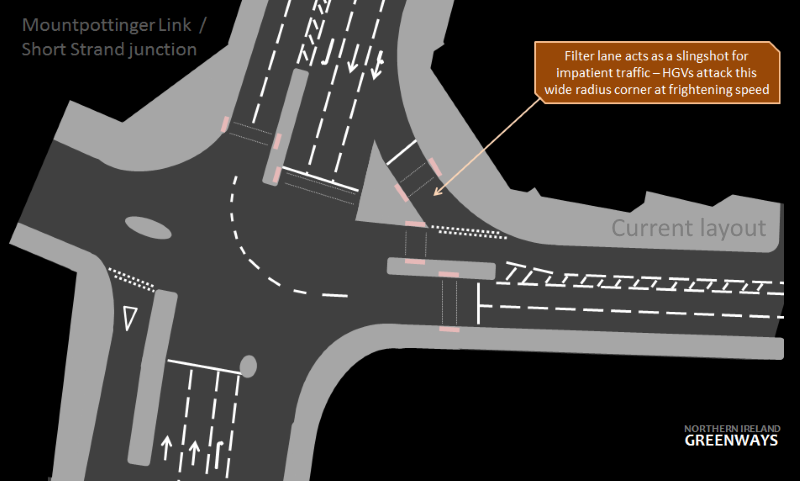
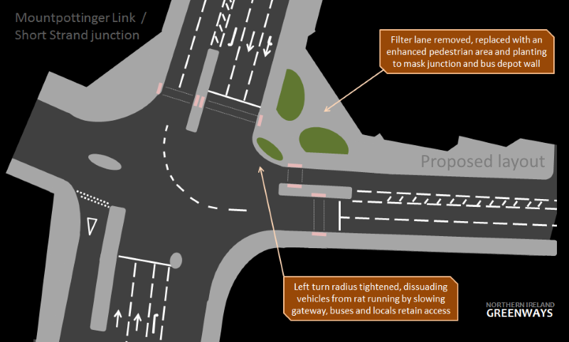
Removing this filter lane, and designing a tighter turn into Mountpottinger Link will allow residents and buses to access the area, but will be slower – making it more difficult for trucks and articulated lorries to negotiate. The straight-ahead option becomes far more attractive in drivers’ minds.


Short_Strand_2


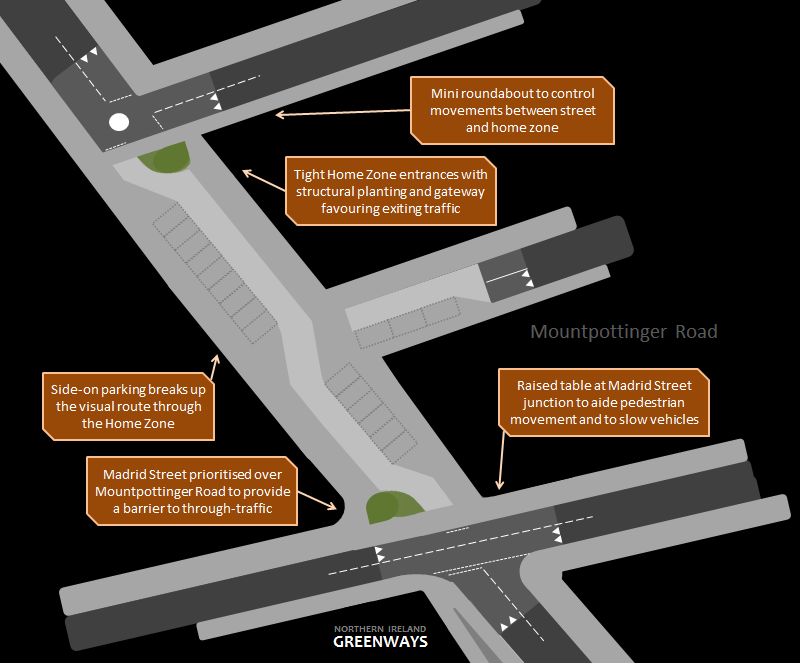
On their own, design changes at the gateways will only dissuade general traffic, but not stop rat-running. Ideally, blocking up Mountpottinger Road at some point would achieve this aim, but would fall foul of objective 3 – annoying local residents to the point of probable objections. One solution however offers a way to ‘snip’ the road without actually closing it to traffic – a Home Zone.


ABD0678
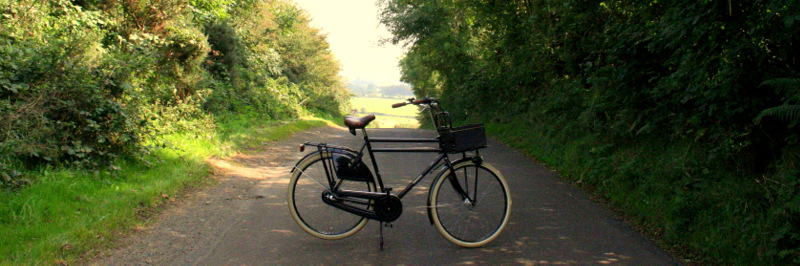
The Dings Homezone development, Bristol (Picture Library Sustrans on Flickr)


These interventions have been trialled in England (but never here) and are a way to radically alter the design of a street to provide strong visual cues to drivers to alter their behaviour, including using build-out elements and designated parking areas to create chicanes to further control speed and movement.

A Home Zone on a short stretch of Mountpottinger Road, in conjunction with work at the gateways, has the potential to solve all the traffic issues in the area at a stroke.


Mountpottinger_1


At the southern end, Madrid Street could be quickly redesigned as a through-road, requiring northbound traffic on Mountpottinger Road to stop and give way. The entrances to the Home Zone could be placed on the right hand side of the road to further confuse users arriving for the first time. Now instead of a fast through-road, general traffic would need to make a significant diversion along Lisbon Street to the left and Edgar Street to the right.

The Home Zone itself could be designed with a single lane, allowing only one vehicle to cross comfortably at a time. Signage for the home zone could include ‘No through-traffic’, ‘Buses, access and parking only’ as more ways to make people wishing to drive through feel uncomfortable and unwelcome. Metro bus services would be the only through-traffic to regularly use the Home Zone – not ideal, but socially important for the area. 10 buses per hour would be an acceptable trade-off to remove hundreds of other vehicles.


Mountpottinger_2


The Home Zone area would be paved to indicate to drivers that this area is not a road for driving at speed, but is for a different purpose. At the northern end a mini roundabout could facilitate movements to/from the Home Zone and between Mountpottinger Road and Beechfield Street.

Drivers arriving expecting to scurry through the area at speed would be met with a series of visual and physical obstacles to progress which, encountered once, would plainly stop any thought of future rat-running.

The benefits of a Home Zone solution include:

  • Radically altered streetscape to remove propensity to rat run through the area.
  • The impact on local residents would be minimal.
  • Risk/reward of rat running tipped away by slower journeys and embarrassment of travelling through a clearly residential place.
  • Bus services can continue to move through Mountpottinger Road.
  • Access retained for emergency services, municipal and utility services, residents parking and local movements.
  • Walking, cycling and street play is promoted through a more pleasant road environment and radically reduced traffic levels.
  • Local vehicle movements across the Home Zone are still possible, if not as attractive as before.
  • Two alternative local routes (Lisbon and Edgar) are available on either side.

Any possible delays to Metro 5A service due to these streetscape changes would be offset by a more reliable journey times at rush hour, with tailbacks eliminated at the junction towards Castlereagh Street. An agreement would need to be reached with Translink to ensure that non-operational services – empty school buses and terminated services – returning to the Short Strand depot would use the bypass route rather than the Home Zone.

The Short Strand faces a daily invasion by impatient drivers, a shameful situation which makes a serious or fatal collision seem inevitable in the near future. The quality of life for residents, young and old, is unnecessarily affected by noise, vibration, fumes and physical danger, and the main authorities with a role in changing the situation – DRD, Belfast City Council to name but two – will fail us by ignoring the problem. A Home Zone-centred street redesign has the potential to make a difference, but a better solution may be out there – it’s time to start that discussion. Through-traffic has no place on these streets, and for the good of Belfast we need to take a stand and recognise the need for change. Short Strand residents could draw some inspiration from their counterparts in the Amsterdam neighbourhood “De Pijp” over 40 years ago..


The footprint of the abandoned Ballymena, Cushendall and Red Bay Railway winds silently through the Glens of Antrim. The scenery along the old narrow gauge railway route is truly magical; it’s time to make a nailed-on tourism case for creating a walking and cycling greenway to lift the local economy.

GLENSbig

The Ballymena, Cushendall and Red Bay Railway opened in stages between 1875 and 1876. The line was initially constructed to service the transport of iron ore from various mines to the north of Ballymena to Red Bay for shipping to England. A depression in the market in the 1880s led to the line being taken over by the Belfast & Northern Counties Railway in 1884 and it was gradually upgraded to enable passenger services.

Due to the difficult gradient down to Cushendall the line terminated 3 miles away at Retreat, and passenger services halted at Parkmore, just short of where the line crosses Glenariff Forest Park today. The station at Parkmore still stands today, just beside the Ballyeamon Rd / Glenariffe Rd junction. Passenger services ran until 1930 and the line ceased all operations in 1940.

© CartoDB and Nokia (follow link for more info)

Ballymena to Cargan

The footprint of the line in Ballymena out to the M2 has been almost fully erased by housing and road development over the decades; it’s impossible to see this being resurrected. For a more contemporary plan to enable leisure walking and cycling trips through the town, the Braid River Greenway offers hope (more later). A brand new link from Broughshane to the old railway line may be possible.

Once out of Ballymena town, intensive farming activity over the last 75 years has removed most traces of the line even from satellite imagery. Occasional glimpses of a railway hedgerow or embankment are rare through Quarrytown until the line reaches Rathkenny – one example being the line approaching the Knockan Road at Turtles Garage in the picture below.

Railway embankment visible at Knockan Road

From Rathkenny to Cargan the line runs in close parallel to the Cushendall Road. This affords a continuous view of embankments, cuttings and tree lines, frequently punctuated by buildings which have cropped up on the old trackbed – the car dealership Wilson’s of Rathkenny being a prime example.

Resurrecting a fully continuous railway line converted to a greenway path through Martinstown to Cargan seems to be a challenging prospect, given this development.

Around and beyond Cargan are the railway sidings which provided the impetus to originally create this railway, to the iron ore mines (see map). This fascinating aspect of local history could be brought to a wider audience by extending pathways outwards from the ‘main line’ along these mining routes, possibly linking in with the Dungonnell Way walking route.

Glenravel

Climbing sharply out of Cargan, the main line frees itself of all building development and hugs the Glenravel Road. Long stretches of embankment dovetail with mountain streams and provide well-worn trails for local livestock.

Looking towards Cargan from Glenravel

At the junction of the main line and Evishacrow mines, the siding bridge can be seen gradually crumbling into the river. Old rails cut to support a concrete track are clearly visible, although the bridge is too fragile to support more than the odd sheep these days.

Mineral siding at Glenravel

The main line sweeps majestically through a valley from here, crisscrossed by the Cargan Water stream, with bridge abutments crying out to carry people across once more.

Ballymena, Cushendall and Red Bay Railway at Glenravel

There is no difficulty selling the idea of a greenway here – this picture (adding a path and tourists) would proudly sit alongside some of our key tourism draws.

Railway winds through valley at Glenravel

Along the stretch from Cargan to Retreat old bridges which used to carry folk over the railway are visible, many braced against the inevitable deterioration which decades of loneliness brings. Imagine how a greenway project could restore these magnificent features to preserve for future generations and signal our pride in our engineering heritage.

Braced bridge near Parkmore

You can read a little more on the history of the area on the Glenravel Historical Society website.

Glenariff Forest Park

I stumbled upon this section in September 2013 and fell completely in love with the place and the greenway idea. There is a pronounced kink in the Ballyeamon Road as it enters Glenariff Forest Park, which obscures a remarkable straight route through the woods for the old narrow gauge railway. This begins as a hulking embankment at the southern end, rising through the trees towards a cutting at the northern tip where the road latches on once more.

Forest cutting through Glenariff

A stream running across the mossy forest floor meant the railway line needed to cross a bridge. The remaining abutments silently stare at each other in this eerie, hidden clearing.

Old bridge abutments in the forest corridor

The towering trees, swaying and creaking gently in the wind, set against this human achievement of driving a railway across the Glens of Antrim gives a truly magical feel to the place. At the head of the wooded section is another old bridge which used to cross the railway line, marking the boundary between the real world and the secret place beyond, evocative of our own C.S. Lewis and stepping into Narnia.

Looking towards forest cutting from Essathohan Bridge

Just beside the forest corridor are the Essathohan Bridges, the rail and road bridges set side by side. This is one end of the Dungonnell Way and pony track around Glenariff Forest Park. Having an established forest park right on the greenway offers the chance to develop camping facilities, allowing tourists on long cycling holidays the option to base themselves in the area for a night or two.

Essathohan Bridges carrying road and rail over Essathohan Burn

Down to Cushendall

From Glenariff, the route crests over the glen and begins to descend towards Cushendall. The Essathohan siding marks the highest point for any railway in Ireland (319m) which in turn would make this the highest greenway in Ireland – a nice selling point.

The embankment pictured here clings perilously to the side of Crockalough as the railway line reaches its terminus.

Looking back towards Parkmore from Crockalough

The engineering challenge of taking the railway down to Cushendall and Red Bay, or more likely the prohibitive cost, meant the line terminated here at Retreat. This perch on the hill provides epic views down towards Cushendall and, on a clear day, all the way to the Mull of Kintyre.

Embankment and bridge abutment at Retreat

With no rail link beyond Retreat, passengers were carried from Parkmore to Cushendall by coach, however to create a world-class greenway a solution to bridge this 3 mile gap from Retreat will need to be found, perhaps along quieter country lanes down the hill.

Like the ideas to reconnect Ballycastle with Ballymoney with a greenway on the old trackbed, or Newcastle with Belfast along the old Belfast and County Down Railway, the pretty coastal village of Cushendall could once more see tourism and leisure traffic driven to the town by the Ballymena, Cushendall and Red Bay Railway line.

Braid River Greenway (Ballymena)

Tucked inside DSD’s Ballymena Town Centre Masterplan (PDF) published in 2009 was a proposal to implement a greenway along the Braid River, likely sometime within the 2020s:

“This would entail the establishment of continuous foot and cycle path connections along its length, connecting outlying settlements such as Broughshane and Tullaghgarley with the Town Centre. The project would create opportunities for improved flood mitigation measures, wildlife habitat and riverfront development where appropriate.”

Looking at the map below there are a number of existing pathways across the town hugging the river bank. An obvious plan would be to link these with an improved riverfront, so shamefully surrendered to the car parking needs of the Braidwater retail park. Who knows, perhaps a Maine River Greenway could link the future greenway at Randalstown to Ballymena and beyond to Cullybackey?

© CartoDB and Nokia (follow link for more info)

The Ballymena, Cushendall and Red Bay Railway wasn’t the only narrow gauge railway terminating in Ballymena. Not content with the idea of a riverside pathway network and a greenway rising up through the Glens towards the coast, there is scope to create a further greenway from Ballymena to Larne – but that’s for another time..

Building the Glens of Antrim Greenway

The case for building this greenway is strong:

  • a rural location keen for investment
  • strong public transport links at Ballymena
  • existing plans to make Ballymena a greenway ‘hub’
  • world-class scenery able to attract external visitors
  • links to leisure facilities (Glenariff Forest Park) and the Causeway Coast

The greenway plan lies between two council areas, Mid & East Antrim Borough Council from Ballymena to Parkmore and Causeway Coast and Glens Borough Council from Parkmore to Cushendall. There is also a large section under the control of the DARD Forest Service through Glenariff. However the majority of the route is likely to be in private ownership following the sale of railway property following closure.

Development of a greenway will depend upon the creation of a strong local lobby and partnership between politicians, stakeholders, community interests and landowners. The Great Western Greenway in Mayo isn’t a copy-and-paste blueprint for solving thorny issues, however the partnership working which delivered and maintains that project is worth reflecting on, as are the documented and cherished economic benefits to that remote region.

Cutting through Glenariff Forest Park

While decades of farming and community growth makes a route out from Ballymena challenging to say the least, the upper reaches of the old line sit in plain view and unhindered by recent human development.

The beauty of the surroundings and the resilience of the cuttings and embankments to survive the decades challenges us to imagine how this line can once again carry people, from near and far, across the Glens of Antrim.

Northern Ireland has it bad when it comes to cycling, with our constant rain and wind, awful drivers and hardly anywhere safe to cycle. Those are the simple assumptions, but what does the public actually think about cycling?

The Department for Regional Development (DRD) has published a report called “Public Awareness of Travelwise NI Initiatives – Findings from Northern Ireland Omnibus Survey May 2014”. You can see the headlines and download the full report here to read how “only 2% of people already cycle short journeys of up to 3 miles (4.8km)” and “over two fifths (42%) of people don’t own / have access to a bicycle“.

Headlines are great, but which golden nuggets caught the eye of @nigreenways? Here’s eight things from the survey which give little-known insights into cycling in Northern Ireland..

Harden ye (weather isn’t a big issue)

The weather is an easy brick to throw at talk of a cycling revolution, yet what seems like a discouragingly wet climate for cycling doesn’t tally with the experience of everyday users. Even on rainy days (it hardly ever rains all day here) bicycle racks in Belfast are more occupied than ever..

The survey shows that weather isn’t a big issue, only making it to fifth place on the list of issues at 19%, down from 24% in 2011. Our obsession with the weather means people here should be experts at sticking the head out the window and judging how dry they’ll be after 20 minutes of cycling. 🙂

weathersml

Interestingly, people are far less worried about bad weather when considering cycling 3 miles than when they’re considering walking 1 mile.

Pensioners are putting kids to shame

Granda

Here’s a surprise – youngsters these days think cycling is too hard. Despite being the group most likely to be already cycling short journeys, at 6% people aged 16-24 are most likely of any group surveyed to say “cycling takes too much effort”. Granny and Granda seem to have less of an issue about covering 3 miles on 2 wheels – just 5% think it’s too much effort. Buck your ideas up young’uns!

Lack of female bike ownership is a problem

Practical

Just 50% of females in Northern Ireland have access or own a bike which would allow them to complete a short journey. This tallies with previous DRD NI Travel Survey data which shows only around one fifth of the female population in Northern Ireland cycles each year, compared with a third of males. Overall bicycle ownership levels are a thorny structural barrier to cycling, but half of women in Northern Ireland simply aren’t in the game.

Cycling’s image problem

IMAGE

It’s often hard to distinguish if cycling makes me look unemployed (can’t afford to buy a car) or affluent middle class (can afford to buy a bicycle) and there’s plenty of people on social media to shout both points at you. As it turns out, there may be a surprising bias against cycling among those who are unemployed, of whom 14% say “I’m not the type of person who rides a bicycle” against just 9% among those who are employed. The other groups with the highest rates are those 65 and over (18%), females (14%) and those with a disability (14%).

Urban cyclists get on better with drivers than rural cyclists

IMG_1308

Cycle camera footage has raised the profile of difficult interactions on our roads, and you might think the busiest city roads would be the cause of greatest resentment. Not so, as 16% of urban dwellers in Northern Ireland say “lack of consideration from car drivers” is a discouragement to short cycling journeys, but almost a quarter of rural dwellers say the same (23%).

Parents can do the school run by bicycle

Albert

Having to juggle a school run with getting to work seems to rule out the bicycle for many people. Perhaps surprisingly, of those surveyed who have dependants, just 11% said “difficulties with managing children” was a problem. And more people without dependants see the car as quicker than the bicycle (8%) than those with dependants (7%).

People are getting wise to the key issues

change

Looking at the change in attitudes over the last three years points to a maturing understanding of how to make cycling better in Northern Ireland. It appears access to bicycles may have dropped (let’s see how the Giro d’Italia and Belfast Bike Hire affects that) but alongside fewer concerns about weather and image, we can see a greater focus on the problems of sharing space with traffic and lack of dedicated cycling infrastructure.

Our cycling levels are shameful

IMG_9599-001

Okay, we already knew this, but yet another survey has confirmed how few people choose to cycle in Northern Ireland. Generously the report records cycling to school at 1% of journeys (16+ years old) while the DRD Travel Survey has shown a spiralling decline below even that woeful mark in the last decade. Male cycling to work levels are at a more encouraging 3%, while female cycling to work levels flat-line at 0%.

In 2011 6% of people said nothing would put them off cycling – that figure has dropped to 3%, a really “significant decrease” of confidence in the hard core regular cycle demographic.

“We appreciate that many people feel that provision is frequently fragmented and of varying quality. Where ‘opportunities’ arise, i.e. provision of bicycle infrastructure as part of road maintenance or upgrade schemes we will seize these opportunities.”

(Draft Bicycle Strategy for Northern Ireland / DRD / August 2014)

Detailed plans have been released to inform a public consultation on the York Street Interchange, a £125m-£165m project to redesign the north quarter of Belfast’s traffic. It marks a key junction for the Department for Regional Development’s (DRD) cycling flirtations, with two ways to turn – allow past mistakes to be repeated, or start to back up active travel rhetoric with action.

Instead of a standard-setting cycling corridor linking York Road with the city centre, poor design elements betray the typical bolt-on approach to cycling provision. Nothing less than the Department’s own Cycling Revolution™ itself is at stake if the heavy-hitting strategic road engineers continue to brashly ignore the needs of those who could choose to use the bicycle.

YSI800

In short, the York Street Interchange (YSI) plan aims to remove the street-level bottleneck at the convergence of the M2 (to the north), the M3 (to the east) and the Westlink/M1 (to the southwest). Of most concern from a cycling perspective is the desperate lack of vision for the main ‘local’ spine of the project, York Street (highlighted in red on the map above) which would serve as a natural focal point for short to medium term cycle infrastructure plans.

It connects a number of key areas – the City Centre, the new Ulster University campus, a large shopping complex and the York Street Railway Station. There are a further 3 points to note when considering the project from an active travel perspective:

  • Streets Ahead Phase 3 about to reshape the northern approach of the centre to enhance the urban environment for shoppers, pedestrians, cyclists and public transport users
  • the woefully indirect National Cycle Network Route 93 skirts the edge of the YSI project area
  • Belfast Bike Hire stations planned in a dense pattern, with future expansion to the north very likely if successful

“Dedicated cycling provision throughout the existing [YSI] area is limited. None of the existing road network currently has adjacent cycling lane provision, thus cycling journeys made through the existing junction arrangement are on-road and in direct interaction with local and strategic traffic.”

(York Street Interchange Preferred Options Report: Volume 1 / DRD / October 2012)

YSIgantry

The current conditions for cycling are awful, with the 5 to 6 lane York Street forming the northbound section of a huge gyratory system. Traffic volume and speed make this desperately unattractive for cycling, and southbound journeys impossible without taking to the (deserted) pavements. The whole area is a tarmac jungle, long ago purged of vibrant street-level human activity.

But the YSI project offered some hope – after all, taking into account the usual physical constraints, DRD and their contracted designers have been working on a blank canvas. While the project objectives and designs may have pre-dated the Cycling Revolution™, we might expect to see something a little bit radical..

https://twitter.com/nigreenways/status/565159017019080704

..but instead we have the usual advanced stop lines, on-road cycle lanes (which the Chair of the All Party Group on Cycling Chris Lyttle referred to as “little more than a few of pots of paint”) and the coup de grâce – a shared bus and cycle lane. Because that’s what old-school road engineers think people riding bicycles in cities want, or certainly can be fobbed off with.

We’ll look later at the archaic cycling provision and compare with developing standards in other UK cities. But a more fundamental problem with the YSI plan lies in the power relationships inside DRD – what good is a Bicycle Strategy if those who design the blue riband strategic road schemes can simply bypass it?

“We will work with other Government Departments, District Councils, the voluntary and private sectors and other interested parties to ensure that the Strategy is fully and optimally implemented.”

(Draft Bicycle Strategy for Northern Ireland / DRD / August 2014)

Cross-Departmental cycling working groups have already been set up to ensure co-ordination of cycling activities across Northern Ireland government. But what about the toughest nut to crack – the vested interests within the Cycling Unit’s own Department? High quality cycling space is absent from the YSI project, including the crucial ‘local traffic’ bridge passing over the sunken motorway connections. Is this because it sits in another “silo” within DRD, which couldn’t give a fig about the “problems” of cyclists?

“I am very clear on where the boundaries of my scheme lie. I am very aware of project creep, because project creep relates to increased costs .. this cannot be seen as the answer to everyone’s problems for the whole of the area. We have accommodated the link through under the Whitla Street underpass, to provide for the linkage to one of the cycle route networks, so there are changes to that. We are consulting with our cycling colleagues to ensure that as far as possible we accommodate them. The reference to the “couple of cans of paint” on the York Street Bridge – I think there has to be a bit of an appreciation of the cost of widening that bridge to accommodate these. It is not insignificant to widen that bridge in those circumstances to provide an extra, say 1.5m on each side.” [my emphasis]

(Roy Spiers / DRD / at the Regional Development Committee, 19 February 2015)

[youtube https://www.youtube.com/watch?v=7pnqhz2fR1w?t=2h18m11s&w=800&h=450]

.

The language is instructive – this is a motorway scheme, a motor vehicle project, something to make car journeys faster. Pedestrians naturally have their footways, and the railway line is immovable, but cars, vans, trucks and motorbikes are the focus, the boundary limit. Decent cycling infrastructure? Improving access for cycling? Not part of the plan. A problem. An addition. Project creep. An unforeseen exception. Not something to be integrated into a £165m project, but a difficult, unreasonably costly (!) and frankly unwelcome accommodation.

By the way, you might consider that to be the biased view of a pro-cycling writer – but it’s writ large in the project brief..

What of that bridge which would have to be widened to “accommodate” the wild demands of the “cycling lobby”?

Cargobike Dad does an excellent job of reallocating the generous motor vehicle space on the bridge, but you only need to look at the real estate given over to “separation strips”. Keeping vehicles apart appears to have a higher priority than providing space for cycling. On questioning the representatives at the YSI public face-to-face consultation event, these 1.6m strips were described as “essential” for traffic lights. This despite the fact there are existing overhead gantries on the road, and another is planned for the new scheme.

Who’s asking for a widened bridge? No-one. That’s a handy bit of bluster to distract from engineers’ unwillingness to imagine that a good quality cycle route should, over time, reduce non-strategic vehicle traffic levels.

“We are committed to creating a network of high quality, direct, joined up routes. We want to make the bicycle an attractive, obvious mode of transport, and to help those who choose to cycle, by having high quality infrastructure which provides greater priority for the bicycle.”

(Draft Bicycle Strategy for Northern Ireland / DRD / August 2014)

It might be worth learning the lessons from the last bridge built over a strategic road in Belfast. Less than ten years ago and a mile away is the Grosvenor Road bridge, rebuilt as part of the Westlink upgrade. Dedicated cycling space wasn’t included, missing another “once in a lifetime opportunity” to remove a physical barrier between the City Centre and West Belfast with its terribly low cycling rates.

As it turns out some DRD engineers managing YSI also worked on the Westlink project. So who is advising the current “Strategic Advisory Group” on the active travel elements of the YSI project, to ensure history doesn’t repeat? Sustrans would be a safe and trusted option for DRD – again the language is instructive:

“The Strategic Advisory Group is a group of individuals who I have invited who, I feel, have a contribution to make to the aesthetics and integration of this. This carries on from a similar group that I had in place for Westlink. If I open this out to all and sundry I get nowhere, is the answer. Sustrans is not on the group. The thing is, I am there, I chair the group, I will be looking at the aesthetics, the integration, user appreciation of the route to ensure that if there is something that we can do to make it more user-friendly in any circumstances for non-motorised users, as well as motorists.” [my emphasis]

(Roy Spiers / DRD / at the Regional Development Committee, 19 February 2015)

That even a (relatively conservative) group like Sustrans isn’t permitted near this little silo in DRD speaks volumes for the chances of dragging blinkered road engineers into the 21st century.

“We aspire to become more like our European neighbours who have embraced the bicycle as simply ‘another mode’ of transport that is accessible, attractive, safe and desirable.”

(Draft Bicycle Strategy for Northern Ireland / DRD / August 2014)

Inconsistent route design

One of the key problems with any cycle route in Belfast (if we have such things) is inconsistency. Whether it’s cycle lanes disappearing at junctions, bus lanes marketed as cycling infrastructure or plainly dangerous design features, these are issues which need to be addressed in all forthcoming road schemes.

Here we have a northbound on-road cycle lane (whether it’s advisory or mandatory is not the point – only paint ‘separates’ bicycles and motor vehicles) and a southbound route largely shared with buses, taxis and motorcycles. It could be lifted from any arterial route in Belfast today where this pattern repeats – and has delivered shamefully low cycling levels to date.

inconsistent

Where space exists beside the bus lane for a separate, dedicated cycle track, instead we have hatching where buses can apparently overtake cyclists safely and without causing intimidation. The lack of insight is par for the course.

No bus stop bypass

Cycling past the busy Cityside Retail Park means potential conflict with buses, which have to cross the cycle lane to reach the bus stop.

© Crown Copyright - published with permission of DRD
© Crown Copyright – published with permission of DRD

The bus stop bypass is a common design feature in The Netherlands, taking the cycle lane behind the bus stop to avoid conflict. It’s beginning to be rolled out in areas of the UK and Ireland where authorities are truly serious about cycling..

Hanging cycle lanes

In quick succession bicycle users will face conflict actively designed into York Street – a left turn into the Cityside Retail Park followed by a left turn to Brougham Street (pictured below).  The cycle lane continues across the turn, leaving a the cycle lane hanging between two lanes of motor traffic. This is plainly dangerous, and a massive barrier to inexperienced or nervous bicycle users.

© Crown Copyright - published with permission of DRD
© Crown Copyright – published with permission of DRD

It’s exactly the type of design one would expect the DRD Cycling Unit to be phasing out, in favour of international best practice.

ASLs everywhere

The advanced stop line cycle box – an easy stamp to show cycling has been catered for, while actually doing nothing to grow cycling levels. And the YSI designers have gone ASL-wild, with a desperately scatter-gun approach.

© Crown Copyright - published with permission of DRD
© Crown Copyright – published with permission of DRD

Some with lead-in cycle lanes, some without; some which are placed at the entrance to a road; one which place the braver cyclist into lanes which lead only to a motorway. There is even a monster ASL which is FIVE lanes wide – and didn’t the wider cycling world laugh at Belfast (it’s worth reading this entire thread for the disbelief) especially when the penny dropped that it already exists..

The ASL is a useless substitute for truly safe junction design, explained in simple terms here by Bicycle Dutch

Transport shift at the University

The importance of active travel at the new Ulster University campus seems to have been given very little attention. By 2018 over 15,000 students and staff will be based on the edge of the YSI site. A quick look at the various planning applications for student accommodation give enough cause for a major objection to the current YSI design. These five plans alone (listed on the excellent Future Belfast website) cater for over 500 bicycle parking spaces, vastly outnumbering the planned car park spaces. This is harsh reality clashing with DRD fantasy..

“We want to be visionary in our approach and we want to embrace innovation. We are developing a long term strategy, spanning a 25 year horizon, to give us the chance to make Northern Ireland a cycling society.”

(Draft Bicycle Strategy for Northern Ireland / DRD / August 2014)

By 2040 the streets in this area should have good quality space for cycling in a dense grid suitable for users of all ages and abilities, linking in with a new bridge across the River Lagan and serving a growing, vibrant inner city population who will be less reliant on car transport. How much of this can be created cheaply and easily now on YSI’s blank canvas, instead of DRD having to return for a costly and disruptive (perhaps prohibitively so) retrofit later?

futureYSI

The Bicycle Strategy took flak for its inclusion of ‘types of cyclists’ which many pointed out could lead to just this type of patchwork design. Any engineer considering how to include space for cycling in the YSI plans should have only one user in mind – an 8 year old child. Get it right for them, and you get it right for everyone.

Whether with a peer group or with their family, ask yourself would an 8 year old feel confident and be safe to cycle through this area? If the answer is no, change the design to make it safe. If you’re wondering why an 8 year old needs to be cycling through a busy interchange, you are the impediment to necessary change.

From the initial aims and objectives of the project through to the delivery mechanisms, ploughing a huge road scheme through a city quarter and denying any responsibility to create benefits for non-motorised users is desperately arrogant. It’s time to hand the ‘local’ sections over to the DRD Cycling Unit which, both technically and politically, faces its first big test. I hope they can strike a decisive early blow for the Cycling Revolution™.

https://twitter.com/herbert_tiemens/status/572504496128966656

Send your views on the York Street Interchange project by the consultation closing date on Tuesday 10th March to:

The Divisional Manager
Transport NI – Eastern Division Headquarters
Hydebank
4 Hospital Road
Belfast
BT8 8JL

Or email to: roads.sriteastern@drdni.gov.uk

For more resources on the York Street Interchange try these sites:

You can vote now in the 2014 Fréd Awards! Over the next week we’ll bring you the stories behind the short lists and those who have been nominated. We start with Cycling politician of the year..

Awards

The runners and riders

Danny Kennedy

A sceptical public took the Regional Development Minister’s call for a Cycling Revolution™ in Northern Ireland with a pinch of salt – what good is a promise without actions?

And then came the first signs of action in 2014. A Departmental Cycling Unit was set up with staff, an annual budget and plans for infrastructure funding..

The Minister got his hands dirty and took in a tour of Copenhagen and Malmö to see how cycling can made mainstream, and help to create better places to live..

Not content with getting on his bike in safe environments, the Minister joined Ride On Belfast and even showed an impressive kick to lead out, then drop, the peloton though the rush hour streets of Belfast..

In October the Minister hosted the Changing Gears international cycling conference in Belfast. Delegates expecting a typical Ministerial appearance (photo, speech, out the door) were impressed by Danny’s engaged attendance through the whole day, his target-laden key-note speech and wrap-up..

An impressive year from a politician who is working from no party manifesto commitment to cycling and operating in a space which can easily draw criticism from lobbies hostile to cycling.

Chris Lyttle

Chris has been instrumental in setting up the All Party Group on Cycling at the Northern Ireland Assembly, which he chairs.

In this role Chris helped to organise a number of events in 2014 including an APG round table discussion on how to get NI cycling, and a cycling safari with the DRD Cycling Unit, Travelwise and local cycling campaigners..

Chris has recently moved on to the Regional Development Committee to (among other things) ensure a strong voice for cycling and as the sole MLA representing Belfast constituencies, epicentre of the Cycling Revolution™..

Máirtín Ó Muilleoir

Former Lord Mayor of Belfast Máirtín Ó Muilleoir is the defending champion in this category..

Máirtín’s time in office was a breath of fresh air in many ways, and he unexpectedly embraced cycling over the course of an impressive year. The appearance of a Mayoral bicycle was complemented by a Giro-rosa hi-viz tabard to give a distinctive appearance around the streets of Belfast – indeed Máirtín took to arriving at Mayoral appearances by bicycle..

And of course, with the Giro d’Italia in town during 2014, what else would Belfast’s First Citizen do but dye his hair Giro-rosa for the week?

Máirtín has now left Belfast City Council to represent South Belfast at the Northern Ireland Assembly. While the bike may not be heading up Massey Avenue too often, we hope Máirtín will take his new found delight in cycling with him.

Daithí McKay

Daithí has already landed the first Fréd Award of 2014, as the Cycling MLA of the Year for asking the most NI Assembly questions on cycling..

You can read more about Daithí’s achievements here, but his work goes beyond the halls of Stormont..

https://twitter.com/MisssPatrice/status/496371445694730240

A prominent member of the All Party Group on Cycling, Daithí also has a real passion for leisure cycling and commuting – no mean feat as his constituency is about 50 miles from Stormont..

https://twitter.com/daithimckay/status/462351690499629056

Although that would be a some daily round trip – this multi-modal commuter makes good use of Translink’s bicycle area..

https://twitter.com/daithimckay/status/478766402829295616

Can Daithí do a unique double at this year’s Fréd Awards? That’s up to you, the voting public..

Sandra Overend

Sandra put herself to the fore of the political discussions on cycling in 2014. After becoming Assembly Private Secretary to Danny Kennedy, Sandra has been a valued member of the All Party Group on Cycling and made an important contribution to the NI Assembly debate on a Giro Legacy for cycling..

Bike Week brought opportunities for MLAs to go on a cycling safari from Stormont to Belfast City Hall and back again, where Sandra and others diced with busy lunchtime traffic to get a real experience of the issues for  everyday cyclists..

And Sandra continues to work closely with the Minister and the DRD Cycling Unit to assess the problems for cycling in Northern Ireland..

Pat Ramsey

Pat’s inclusion in the short list for Cycling politician of the Year 2014 might raise eyebrows for those with long memories, but he’s here on merit for some impressive and largely unheralded work during the year..

Pat picked up where Conall McDevitt left off in 2013 by resurrecting the Private Member’s Bill to make 20mph the default speed on residential roads in Northern Ireland..

The progress of the Bill will be interesting to watch in 2015.

John Barry

John’s bid for election to the new North Down & Ards District Council was unlike many others in the 2014 elections – the Battle Bike was key in his effort to meet potential voters..

https://twitter.com/CllrJohnBarry/status/469407008769458177

After suffering previous disappointments, the bicycle strategy along with his trademark personalised hi-viz tabard saw him romp home.

Not content with putting the bicycle front and centre in the electoral process, John took part in the inaugural Fréd Debate during Bike Week. He valiantly argued for the motion that “Belfast can never become a cycling city”, failing to convince the house (and himself) in the face of his former QUB student Thomas McConaghie’s passion and logic..

[youtube https://www.youtube.com/watch?v=FdD4s7rfxdo?rel=0]

Sammy Douglas

Sammy is another politician who’s a genuine everyday bicycle user for many reasons – for health, for quick journeys, or just for the love of it..

Cycling isn’t just about commuting, leisure, shopping or racing – it’s an important tool of social cohesion. Sammy’s work with the Ballybeen Men’s Group shows the benefits active travel can have in disadvantaged communities in Belfast..

Although we think this Tweet might be shameless politicking by Sammy – a picture of his bicycle with a cat in the middle of Fréd Awards season?! A canny politician at heart..

https://twitter.com/sammydouglasmla/status/534009990580019200

Give your favourite cycling politician (from this list or your own choice) a vote in the 2014 Fréd Awards now!

2014 Fréd Awards

The Draft Bicycle Strategy for Northern Ireland needs your input. A public consultation is running until Friday 21st November 2014, and your views will help to determine the path which DRD will plot over the next 25 years to deliver the Cycling Revolution™ in Northern Ireland.

drd_bicycle_consultation_event
DRD Cycling Unit Head Andrew Grieve at the Belfast consultation event

You can read the full Draft Bicycle Strategy for Northern Ireland by downloading it from the DRD website. You can respond to the Draft Strategy a number of ways, listed at the end of this article.

So, what are the hot topics for @nigreenways in the Draft Strategy?

That headline vision statement

“To establish a cycling culture in Northern Ireland to give people the freedom and confidence to travel by bicycle, and where all road users can safely share space with mutual respect.”

Normal
Confusing pre-Bicycle Strategy outbreak of everyday cycling; ignore this..

A decent start, but it’s a few tweaks away from perfection..

Don’t repeat the past mistake of positioning the Bicycle Strategy as a government-led attempt to cold start growth in cycling. Credit is due to DRD for your work over the last year to create the Cycling Unit and this Strategy, but you are pedalling furiously to catch up with the reality on the ground.

TronBelfast

Cycling is on a clear growth curve, even if it remains quite niche as a province-wide activity. An inspired and serious government intervention is needed to push cycling into the mass market. Take this obvious opportunity to put the Bicycle Strategy on the front foot and present a far more efficient vision statement..

“To build on the developing cycling culture in Northern Ireland and create the conditions to give everyone the freedom and confidence to travel by bicycle.”

Sorry, but the twelve words after “bicycle” in your vision is meaningless fillerIt sounds like a really bad DOE road safety advert (and there are many of those) and I genuinely believe the DRD Cycling Unit is better than that. Drop it. Inspire us.

Bicycle Strategy or Cycling Strategy?

“We feel that it is significant that this document is called a ‘Bicycle Strategy’ rather than a ‘Cycling Strategy’ as it presents a clear signal that we are planning for a mode of transport, rather than simply the activity of ‘cycling’.”

Ride11
Two bicycle riders in Belfast arguing about the title of the strategy

It’s astounding how much precious time and oxygen was wasted at stakeholder consultation events discussing this. Knock yourself out. Moving on..

Design for everyone, or no-one

One section of the Draft Bicycle Strategy for Northern Ireland caught the attention (and ire) of cycling campaigners across the UK and Europe:

designing_for_bicycle_users

Northern Ireland’s very own Dutch cycling expert Cargobike Dad put it perfectly in his own takedown of this section:

“The table has been adapted from the English Department for Transport, published in 2007 .. if we want to look at best practice we should not look to England 7 years ago. It would better to hold them up as an example of how not to implement a cycling strategy.”

As for those fast commuters, alarm bells should be ringing at DRD when everyday bicycle commuters with decades of experience can’t take the hassle on Belfast’s busiest roads any more..

https://twitter.com/stevenpatt99/status/532246062283882496

What are the logical outcomes of designing for types of cyclists when DRD considers future route development plans? That high-quality separated cycling infrastructure is less likely around workplaces, or on arterial routes? That it’s more likely around schools? How do you measure the demand among different groups in any particular area? Good luck showing me an area in Belfast that is purely dominated by one of these types, especially if the Cycling Revolution™ actually happens.

This section got a roasting back in August..

profiles

I was planning to write a pithy tirade detailed explanation of why the inclusion of user profiles is a very bad idea, but I’ll give you a 100% guarantee that this section of the Draft Strategy is going to be quietly dropped for the final version. Why? Fast forward to November and everything changed..

bricycle

And who is @bricycle? He’s Brian Deegan, Principal Technical Planner at Transport for London who’s worked in project management on the London Cycle Network for the past six years – and one of the speakers at the recent Changing Gear conference, organised by (wait for it) the DRD Cycling Unit..

The simple principle behind the world’s best cycling infrastructure (also highlighted by Brian Deegan at the conference as being in The Netherlands) is that cycling infrastructure should be designed for everyone to use. To plan a Bicycle Strategy on any other basis puts compromise at the heart of the next 25 years of development.

Cross-government buy-in

“Our ‘cycling future’ is interrelated with a number of other factors .. responsibility for some of these areas sits with other Government Departments or public bodies. For this reason we feel it is vitally important that we work across the sectors to develop and implement this strategy to make sure that the greatest benefits are delivered for everyone.”

https://twitter.com/cvharper999/status/442341953297219584

This is crucial to success – access to the power and influence of the shocking number of government organisations with responsibility for cycling here will determine positive outcomes. Understanding of the needs of cycling development is patchy – eg the Public Health Agency definitely gets it, but the Department for Social Development (leading on public realm projects) does not..

Along with finding guaranteed annual funding for this grand vision, how well the DRD Cycling Unit and the Minister can marshal and direct cycling activities across government will determine the Bicycle Strategy’s success. Which leads us neatly on to..

Aiming.. where exactly?

“We have consciously chosen not to set an arbitrary Northern Ireland wide target for the percentage of people cycling by a nominal date as we do not think it will be useful in encouraging people to use the bicycle as a mode of transport at local level. The Delivery Plan [to follow] will contain a series of specific, measurable, achievable, realistic and time bound objectives, policies and actions. This will form the basis for the monitoring undertaken on the progress made by the Strategy.”

IMG_9754-001
Cycling growth evident in winter rush hour, but cycling still pushed to the margins (by DSD again)

After many discussions I understand (and to some extent sympathise with) DRD’s rationale for not placing an over-arching target within this strategy. The subsequent Delivery Plan, city and local area masterplans will carry the SMART objectives and targets. Grand, and the campaigning corps can’t wait to get its teeth into those plans.

Having no big target(s) may lend flexibility to your work, or could be the biggest flaw in the foundations of the Bicycle Strategy. A big target certainly isn’t “useful in encouraging people to use the bicycle” but it is close to essential in navigating the political stream for 25 long years.

Consider this statement by Minister Danny Kennedy at the Regional Development Committee on Wednesday 12th November 2014 (28:03 onwards):

“The Chair and this Committee will know about the challenging financial position that we find ourselves in, particularly next year. But this is a Programme for Government commitment (it’s also a commitment that I’m committed to) and so the necessary finance will have to be effectively ring-fenced for this project to be carried forward. And that is a challenge for this Department, and it’s a challenge for me, but I have to rise to that challenge. And I’ve no doubt that I would rise to the challenge with the support of this Committee, with Executive colleagues, with the Assembly in general and with public opinion..”

Imagine a future Transport Minister defending DRD Cycling Unit infrastructure plans with this robust certainty. This particular issue was about a railway upgrade plan in difficulty, but because it’s in the Programme for Government (PfG) there’s no argument about “if”, just “how”.

Cycling needs its own place among the PfG targets. Splitting by urban/rural, or Belfast/rest of NI makes a lot of sense given the diverging cycling environments. But if cycling infrastructure planning and/or an over-arching growth target is in there after the next election, a mainstream budget will be easier to embed, and suddenly cycling climbs one more step above the day-to-day political fray.

Will a series of area plans with targets and budgets make into the PfG? That’s highly doubtful. Does this risk leaving each plan to fight tooth and nail for survival in a hostile political environment?

So make sure you’re being smart about that target decision, and think about the realpolitik in 2 years, 5 years, 10 years, 20 years from now. Can you make it politically super difficult for the next Minister to roll back on commitments made in the Bicycle Strategy? Can ambitious headline targets foster competition between political parties to build reputations, policy commitments and delivery on cycling? Or will you be kicking yourselves as the vision and aspirations slowly evaporate over the years?

I welcome the Draft Strategy, but more importantly I have faith in the quality of the people who are working in the DRD Cycling Unit. This is a once-in-25 years opportunity to get it right..

What do you think?

Those were just a few of the key topics covered by the Draft Bicycle Strategy for Northern Ireland. Please do take the time to read it and send your thoughts to the DRD Cycling Unit. For more perspectives on the document you should also:

How to respond

Anne Burke
Cycling Unit
Department for Regional Development
Clarence Court
10-18 Adelaide Street
Belfast

Telephone: 028 9054 0179
Fax: 028 9054 0662
Minicom/ TextPhone: (028) 9054 0642
Text Relay Service: (028) 9054 0179
(prefix 18001)

Email: cycling.unit@drdni.gov.uk

https://twitter.com/stevenpatt99/status/533592297573994496

The spectacular Dark Hedges near Armoy in County Antrim provided a perfect natural set for the Kingsroad in Game of Thrones. However a piece of hidden history could build on the Game of Thrones tourism boost. A small stone bridge marks the old Ballymoney to Ballycastle railway line, and potential future greenway.

GreenwayOfThronesSM

Game of Thrones, HBO’s international hit series filmed in Northern Ireland, is creating a new tourism market. Several memorable locations are dotted around the Causeway Coast, including recent filming for Game of Thrones Series 5 in nearby Portstewart. With the series expected to continue production and be on our screens for several years, and the large loyal following for the original book series by George R.R. Martin, experience tourism for Game of Thrones in Northern Ireland will continue to provide an important niche in the local economy.

https://twitter.com/G_O_T_fans/status/461872846802014208

The Dark Hedges has always been a spectacular location for North Coast visitors, and its inclusion as a section of the epic Kingsroad running through Westeros in the Game of Thrones television series adds a unique selling point to a great opportunity for the local economy..

Ballymoney to Ballycastle Greenway

The Ballycastle Railway opened in 1880 running between Ballymoney to Ballycastle. It was a narrow gauge railway which operated passenger and freight services for almost 70 years until it was closed by the Ulster Transport Authority 1950. Ballycastle’s position as a seaside town meant a boost from the tourist traffic generated by the railway. The current drive across Ireland to re-open derelict railway lines as walking and cycling pathways (and as successful rural regeneration schemes) makes a compelling case for developing a Ballymoney to Ballycastle Greenway.

Greenway_of_Thrones

Ballymoney is a great starting place for the greenway for a number of reasons:

  • a large town population
  • the railway station linking Ballymoney with Belfast and Derry~Londonderry
  • an existing traffic-free path running from railway station to proposed greenway
  • the future plans to upgrade A26 to Coleraine which should create a quality cycle route to Causeway Coast

The Riverside Park pathway is a great facility for local residents in Ballymoney, which shadows the footprint of the old railway line where it diverges from the current track.

Ballymena_Greenway
Riverside  Park ‘Greenway’ path running just below the old Ballycastle Railway line in Ballymoney

The old line is now cut by the Frosses Road bypass (see the tree line to the right of the blue sign above) but it continues northwards on the far side, under Kirk Road before running parallel to Knock Road..

Ballymena_Greenway_KnockRd
Looking towards Ballymoney from a bridge beside Knock Road

This enchanting view makes a greenway easy to visualise, however a common problem on abandoned railways is seen under the beautiful stone bridge..

Ballymena_Greenway_KnockRdBridge
Bridge beside Knock Road being used as a dump

Further along, the trackbed has become a working lane for local farmers, as the line crosses Conogher Road..

Ballymena_Greenway_ConogherRd
Farm lane on former railway line from Conogher Road

The line continues across farmland and the Bush River before turning East as it skirts the edge of the village of Dervock. A sign for “Station Road” gives away the history of the area, but otherwise there are few remnants of the railway here today. The experience of the Great Western Greenway in Mayo has seen great transformation with thousands of otherwise unexpected tourists bringing business and local employment opportunities to small rural settlements.

The undulating treeline of the railway is clearly visible on Google Maps heading towards the next road crossing, with an impressive bridge at Mostragee Road..

Dervock_Greenway_MostrageeRd
Road bridge at Mostragee Road

As with a number of points along the abandoned railway, housing development since the closure may require route diversions during any greenway development. Crossing the Ballinlea Road the old line heads towards the first highlight for potential greenway users.

The Dark Hedges / Kingsroad

At almost the halfway point between Ballymoney and Ballycastle the line passes underneath the Bregagh Road. In the 18th century the Stuart family planted this row of beech trees on the approach to Gracehill House, and the Dark Hedges have grown to become a world-famous visual spectacle. On the southern end a small stone bridge goes largely unnoticed by visitors, yet steam trains thundered past here over 130 years ago.

In the Game of Thrones television series, the Dark Hedges was transformed into a spectacular section of the Kingsroad, where King Robert Baratheon marches to King’s Landing with a combustible party of Starks, Lannisters and assorted destestable characters.

Dark_Hedges_Greenway
View of the Dark Hedges from the Ballycastle Railway bridge

The Dark Hedges already attracts tens of thousands of visitors each year, which creates some problems given the limited parking (a car is the only realistic way of reaching the area) and ongoing issues with environmental damage, due in part to not catering for the reality of this iconic tourist attraction..

“The site should at least be made a conservation area and the footprint extended to include the land on either side of the trees, the historically important Gracehill House and the dismantled Ballymoney to Ballycastle narrow gauge railway – which has great potential as a cycle route/walkway.”
Photographer Bob McCallion interviewed in the Ballymoney and Moyle Times (May 2014)

Dark_Hedges_Greenway_Bridge
Looking under the bridge at the Dark Hedges

Working with the local landowners to address these problems in conjunction with creating a new traffic-free access for visitors could benefit the whole area.

The line continues towards Armoy with an embankment section leaving this impressive bridge abutment visible at Chatham Road..

Dervock_Greenway_ChathamRd
Bridge abutment at Chatham Road

Like Dervock, Armoy stands to benefit from local and external tourism traffic passing through all year round. It’s already home to the world-famous Armoy Road Races in mid summer, where the start / finish line at the Hillside Road coincidently is at a point where the old railway line runs right beside the road.

An embankment is visible to the west of the Hillside Road as the line head north east towards Capecastle. It’s here we find another wonderful attraction of the old railway and any future greenway – the Capecastle Tunnel.

Capecastle_Tunnel_Greenway
Capecastle tunnel

The tunnel is 66 yards long, visible near the junction of Islandarragh Road and Hillside Road where the old Capecastle Railway Station was sited. The stonework is in fine shape, but the trackbed itself is covered in water.

Capecastle_Tunnel_exterior
Looking down at the southern entrance to the Capecastle tunnel

Restoring this tunnel to its former glory by allowing walkers and cyclists to travel through it as part of a future greenway would be an excellent attraction..

Capecastle_Tunnel_approach
View from Capecastle tunnel (looking towards Dervock and Ballymoney)

The old line continues through cuttings and embankments under the shadow of Knocklayd(e) Mountain, with several crumbling embankments visible from Hillside Road. As the line falls towards the coastline, we meet the Moyle Way – emerging as a forest trail which then makes use of the trackbed on the sweep down to Ballycastle town. The path emerges at Fairhill Street under a beautiful stone bridge..

Ballycastle_Greenway
Bridge at Ballycastle with existing rambling path on old Ballycastle Railway line

Another magical grassy pathway leads from the other side of Fairhill Road towards the town centre, almost pleading with you to take a dander..

Ballycastle
View towards viaduct and Ballycastle Railway Station from Fairhill Road

Before the old railway line terminated at Ballycastle Railway Station the small matter of the Tow River had to be crossed – a stone arch viaduct, mostly hidden from public view, stands as a proud testament to our engineering heritage – worthy of being the centre of redevelopment. It’s particularly odd that the last Ballycastle Town ‘masterplan’ (2009) didn’t even reference the viaduct – many other towns would celebrate and protect this type of gateway..

https://www.facebook.com/ballynahinchjunction1950/photos/a.573523122742998.1073741841.312792468816066/573523596076284

Finally the old railway station is now the town’s Ulsterbus station, is a little less glamorous than its railway predecessor with sad derelict reminders of past glories..

Is a Ballymoney to Ballycastle Greenway possible?

Like any potential greenway project, land access is the biggest hurdle, as explained by Northern Ireland’s Regional Development Minister Danny Kennedy:

“Unfortunately, the majority of the track bed of the former Ballymoney to Ballycastle railway line was sold to numerous parties in and around the mid- to late-1950’s. The only portion of the track now left in Translink ownership is the part which now houses the bus station in Ballycastle.”
Regional Development Minister Danny Kennedy in response to AQW34586 by Daithí McKay

The experience of many greenways across the UK and Ireland is that solutions can be found if the community and landowner will is there to see it done. Although the particular model may not transfer, it’s remarkable that over 160 farmers and landowners co-operated to allow the Great Western Greenway in Mayo become a reality and success..

“It is amazing what can be done if everyone in a community pulls together.”
Great Western Greenway submission to Northern Ireland Regional Development Committee

No doubt the challenges to seeing a fully-realised greenway from Ballymoney to Ballycastle will be sizeable. But the project has a number of natural advantages:

  • traffic-free pathways already at each end
  • a natural tourist draw at the Dark Hedges (and the wider Causeway Coast)
  • the railway connection at Ballymoney
  • a well-developed tourism economy in Ballycastle

Local entrepreneurship is shown to be stimulated by this type of investment, with bike hire, cafés and craft shops being an obvious and viable step for people looking to start their own business. Greenways have a pleasant habit of providing younger generations in rural communities with an alternative to moving away from the area to find employment.

Projects like this need to be driven from within an enthusiastic local community, and that is the next step. The Game of Thrones tourism link, along with some spectacular natural and human-made points of interest give the Ballymoney to Ballycastle Greenway a great chance of getting off the ground. If local residents, farmers, landowners, community groups, regeneration organisations and politicians can see the potential, we may yet be able to create the Greenway of Thrones.

Explore the remnants of the Ballycastle railway trackbed on Google Maps..

[googlemaps https://www.google.co.uk/maps/ms?msa=0&msid=202802535379582075161.00050578433a096f470ba&hl=en&ie=UTF8&t=h&ll=55.140032,-6.39473&spn=0.156987,0.411301&z=11&output=embed&w=600&h=400]

Northern Ireland’s Transport Minister Danny Kennedy hopes a significant chunk of his legacy in office will be his “cycling revolution”. Yet taxi reform being brought forward by Environment Minister Mark H Durkan threatens to destroy cycling levels in Belfast, by giving vast numbers of taxis priority over bicycles in rush hour. Their gain will be our loss, but what if our government is betting everything on the wrong horse?

What isn’t widely known is the steep decline in taxi usage over the last 10 years, in parallel to exceptional cycling growth – which is set to propel the importance of the bicycle up alongside and above the taxi sector in key areas of Belfast transport.

Belfast taxis saw a sharp 24% decline in commuting patronage between 2001 and 2011 – even in West Belfast where the taxi sector is dominated by cheap, flexible and socially-cohesive taxi bus services. In every area of the city cycle commuting increased – most notably in South and East Belfast, where bus lanes are virtually empty of permitted taxis during rush hours.

Commuting

If the taxi decline and cycling increase are indicative of a more general trend in Belfast, cycle commuting looks on course to overtake taxi commuting by the 2021 Census. Admittedly it’s a leap to project forward from just 4 data points, but the irony will be lost on no-one that the ‘cross-over’ year happens to be 2015 – when all taxis are due to be let into bus lanes..

Projection

Commuting to/from work might be a narrow look at overall transport usage, but it’s actually very pertinent to this issue, as Belfast bus lanes naturally target only rush hour periods when commuting (along with the school run) creates the greatest congestion.

Sharp and spiralling decline in taxi use?

So is there an underlying decline in the importance of the taxi sector in NI and, if so, why give taxis privileged access to bus lanes at the expense of thriving cycling levels, which relies heavily on bicycle users’ perception of safety?

Maybe the projection above isn’t such a leap if we look at journey trends from DRD’s own annual Travel Survey for Northern Ireland. Taxi journeys have slumped over the 13 years of the survey, from a high of 21 per person per year (pppy) between 2000 and 2005, down to just 12 in 2011-13.  Average distance travelled similarly has dipped from 78 miles pppy in 2001-03 to just 53 in 2011-13. Meanwhile cycling shows sustained growth in almost every count since 2007 – the pre-cursor to our Minister’s ‘cycling revolution’.

TAXICYCLESTATS1

The last graph on Belfast average distance travelled is even more interesting. Taxi travel at 94 miles pppy in 2010-12 is the lowest figure since the survey began. The prominent peak just happened to coincide with Belfast’s opulent property boom of the mid 2000s, followed by a sharp decline tracking the bust years and continuing austerity; draw your own conclusions.

And in this period of falling demand for taxis in Northern Ireland, what has been happening to supply? It turns out, there has been a massive expansion in the number of taxis in Northern Ireland. Between 2003-04 and 2010 there was a 55% increase in the number of taxi vehicles licensed to be on our roads.

taxigrowth

I wonder if DOE knows how many of those additional taxis licensed since 2003-04 were registered as Public Hire outside Belfast (white plates) but actually cruise around the city’s street operating out of private hire depots?

We want more people to travel in Belfast by bus, with impressive investment backing this aim up. Already in Belfast, more people are cycling more often and further than ever before – this is worth building upon. At the same sime, there are more taxis chasing fewer passengers than ever before. Why on earth should this declining sector become the dominant user of bus lanes?

So why redefine bus lanes?

In the Rapid Transit | Taxis in bus lanes article we saw how DRD defines the purpose of bus lanes, which can become quite complex given the different types of vehicles allowed. I think it can be boiled down to two simple reasons for granting access to groups of vehicles – to promote a particularly beneficial transport mode and for increasing the safety of vulnerable road users.

Promotion – when prioritising vehicles capable of carrying more passengers than a typical car (buses, taxi buses and many wheelchair accessible taxis) there are clear benefits to society in reduced congestion, more efficient mass transport, reduced land demand in the city centre for parking – among others. Wheelchair accesible taxis also give disabled customers greater flexibility in travel options, and bus lane access can even be seen as some small mitigation against the increased purchase costs by a taxi driver, encouraging beneficial investment.

Safety –  by some distance, bicycle and motorcycle users are at greatest risk of being involved in a collision leading to serious injury or death. Bus lanes afford two-wheeled users some calm road space within hectic rush hours. Indeed, the choice to cycle or not is in a large part dictated by the perception of safety, something unlikely to put many people off driving or riding as a passenger in a bus or taxi.

buslanevenn

Bicycles sit neatly in the middle of this spectrum, almost the perfect bus lane users. This space is actively used to encourage more cycling in Belfast, and safety needs are catered for by relatively empty space in the busiest periods on our roads.

The question for both Mark H Durkan and Danny Kennedy is simple – where do you see 4,000+ (mostly saloon car) taxis fitting into this picture?

Is anyone calling for a ‘taxi revolution’?

Are we actively encouraging people to make more taxi journeys in Belfast? If so, the evidence shows a clear trend in the opposite direction. Is there an obvious need to increase safety for taxi drivers or passengers, above any other user? Hardly, and certainly no arguments on this point featured in the DRD consultation on taxis in bus lanes.

Even worse, letting 4,000+ taxis dominate bus lanes impacts on all other users’ benefits as shown above – increased competition reduces the attractiveness of bus transport and risks the £100m public investment in Bus Rapid Transit; any chance to use bus lane access as a tool to increase the supply of wheelchair accessible taxi vehicles is lost; historic taxi bus routes risk being drowned out of existence; and the obvious reduction in safety for vulnerable users will hit the ‘cycling revolution’ hard.

Mark H Durkan’s immediate predecessor as Environment Minister realised the damaging side-effects of taxi reform on bus lanes and (late in the day) began the process of working on a resolution to the benefit of bus passengers, taxi bus patrons, wheelchair users and cyclists:

At the moment, the only taxis that can use bus lanes are public hire (the black taxis) and I’ve written to the DRD Minister saying to him I think (whilst that’s his decision) I think that’s the way things should go; that only public hire (black taxis) should be allowed use the bus lanes in order to ensure .. that Belfast keeps on the move. If you’ve a bus lane that ends up with all sorts of taxis using it, then you defeat the purpose of Belfast on the Move, which is the .. DRD strategy to try to keep the city moving..

Alex Attwood (former) DOE Minister, May 2013 [from 4:13]

[gigya src=”http://abfiles.s3.amazonaws.com/swf/audioboom_default_player_v1.swf” style=”background-color:transparent; display:block; min-width:320px; max-width:700px;” flashvars=”image_option=small&imgURL=http%3A%2F%2Fd15mj6e6qmt1na.cloudfront.net%2Fi%2F4678619%2F300x300%2Fc&link_color=%2358d1eb&mp3Author=The+Nolan+Show&mp3Duration=567264.0&mp3LinkURL=http%3A%2F%2Faudioboom.com%2Fboos%2F1380668-minister-alex-attwood-explains-new-rules-governing-how-taxis-operate-here#t=4m13s&mp3Time=09.14am+09+May+2013&mp3Title=Minister+Alex+Attwood+explains+new+rules+governing+how+taxis+operate+here.&mp3URL=http%3A%2F%2Faudioboom.com%2Fboos%2F1380668-minister-alex-attwood-explains-new-rules-governing-how-taxis-operate-here.mp3%3Fsource%3Dwordpress&player_theme=light&rootID=boo_player_1&show_title=true&waveimgURL=” width=”600″ height=”150″ allowFullScreen=”true” wmode=”transparent”]


In the year since taxi reform was paused, DOE have rolled back on this position – why? In face-to-face meetings I’ve had with DRD officials over the last 18 months the message has been clear – DOE’s taxi reform is giving DRD a ‘hospital pass’, forcing a change which the ‘Transport’ Department has no great desire to implement. The unintended consequences of levelling the playing field for all taxis is an end to the fine balance among current bus lanes users – a once-in-a-lifetime irreversible decision to benefit a taxi sector in apparent decline, at great cost to growing sustainable transport.

Of course taxis are, and will remain, an important component of the overall transport system in Belfast and Northern Ireland. But the overall contribution of the taxi has reduced, while the bus and bicycle have gone from strength to strength.

The challenge is now for Environment Minister Mark H Durkan to work with the Regional Development Minister Danny Kennedy to find a better way forward – for the greater good.

It’s very clear that people who cycle in Belfast do not want 4,000+ taxis to hassle them in bus lanes. But the elephant in the room in this debate is sizeable – a £100m elephant in the shape of the forthcoming Bus Rapid Transit system. Now that we know just how wrong the public consultation on bus lanes was, isn’t it time to re-evaluate the effect on the largest group of bus lane users – bus passengers?

BRT

Image owned by RobertG and is licensed for reuse under the GNU Free Documentation License version 1.2. See this image’s original location on Wikipedia Commons.

Infrastructure work on the new Bus Rapid Transit (BRT) system for Belfast has already begun. The new routes are due to begin operation in 2017, with bold promises from the Department for Regional Development (DRD) on the change they will bring for the city:

“BRT will create a new and dynamic bus-based public transport system for Belfast. [It] will provide a modern, safe, efficient and high quality service which encourages people to travel by public transport instead of car.” [DRD]

Bus transit was chosen over light rail/tram due to cost and flexibility (among other factors) but one thing that stands out about the Belfast system is that it will be almost exclusively on-road, sharing space with general traffic. Many BRT systems around the world use dedicated (even guided) running tracks, giving the system a guaranteed time advantage over general traffic.

[vimeo 12472119 w=600 h=450]

Bus Rapid Transit: Bogotá from STREETFILMS on Vimeo.

The speed, reliability and comfort of the BRT services will provide an attractive alternative to private car use.” [DRD]

In a sense this is a qualified £100m gamble by DRD – a Rapid Transit-light or Metro-plus option whose success will be almost entirely based on the attractiveness, speed and reliability brought by off-board ticketing, junction priority and clear bus lanes. A BBC News report in January 2014 on BRT public awareness events became an unfortunately ironic reminder of the current issues with taxis in bus lanes:

So what is the purpose of a bus lane?

Bus lanes are provided primarily for buses to afford them some priority on the road network in recognition of the fact that the stop/start nature of the operation increases journey times making it unattractive as a mode of transport. Bus lanes provide a better level of service for those choosing to use a more sustainable mode of travel. They are also a very visible indication of our commitment to public transport.” [DRD consultation (PDF, 1.15MB)]

Given the locations in Belfast and current operating times, it might be fair to boil it down to a much more simple level – getting people to and from work. Comparing the importance of buses and taxis in this regard in Belfast is revealing. Bus (+ minibus & coach) commuters outnumber taxi commuters by almost 6 to 1 in Belfast, but the ratio of Metro buses to taxis in the city is 1 to 15:

BelfastCommuters

BRT will naturally target a wider audience through the day, but with vehicles planned to be 18 metre articulated buses with a capacity of around 100 people, and all of the infrastructure works and heavy promotion expected, the number of bus commuters in Belfast should grow. So what will 15 taxis for every Metro bus do to average journey times in Belfast, and the future Rapid Transit system?

The taxis in bus lanes consultation (which cutely avoided any reference to Bus Rapid Transit) was surprisingly clear on the effect:

Allowing all taxis into bus lanes would see the number of vehicles using bus lanes increase. It is highly likely that this will impact on the performance of bus lanes in terms of bus speeds and journey times.” [DRD consultation (PDF, 1.15MB)]

It’s a sensible assessment – taxis allowed in bus lanes will be stopping to collect passengers (BRT’s East and West routes run along mixed residential and commercial streets), stopping to drop off passengers while settling fares, and there will be an increased weight of bus lane traffic queued at junctions. Regardless of this, DRD ploughed ahead with their option to allow all taxis into bus lanes, prioritising taxi customers to the disadvantage of bus passengers and inexplicably gifting the taxi sector a competitive advantage over Bus Rapid Transit.

The Consumer Council’s response to the Taxis in bus lanes consultation (PDF, 488k) strikes at the heart of DRD’s £100m gamble. While neither agreeing or disagreeing with DRD’s proposals, the Council felt the journey time issue hadn’t been thought through:

For [DRD] to implement these proposals whilst recognising they have the potential to increase journey times for public transport passengers appears to contradict aims and targets set by the Department in the Regional Transportation Strategy along with other policies and schemes such as ‘Belfast on the Move’. Any perceived benefit for taxi passengers these proposals may provide must also be considered in light of the potential negative impact on cyclists, users of current public transport services and potential users of the proposed Rapid Transit system proposed for Belfast.

And remember, this is based on the assumption of just 2,000 taxis being allowed in Belfast bus lanes..

You got to know when to hold ’em, know when to fold ’em..

No reference was made to Belfast Rapid Transit in the DRD consultation. No reference was made to similar BRT systems operating in shared space with a significant taxi fleet. No care seems to be given to bus passengers’ journey times and the overall aims of providing a compelling “alternative to private car use”. Just as with the concerns for cycling, DRD seems oddly happy to make a blind raise on bus lane access for thousands of taxis to solve an immediate problem, while gleefully ignoring any long-term negative impacts.

The consultation process does not stand up to serious scrutiny; Belfast taxi fleet numbers assessment only told half the story. The sensible move, given the level of public investment in BRT at this time of austerity, would be to shelve the plan to allow all taxis into bus lanes until BRT has a number of years to bed in. Potential impacts of sharing space with taxis can be assessed in real-time, based on a retaining the hackney cab/wheelchair accessible fleet to operate in bus lanes alongside BRT.

Judging by the reaction to every challenge to their consultation process (during and after) Departmental officials clearly don’t see an issue here. DRD are showing a remarkable poker face, given the incredibly weak hand they’re holding. But who can call their bluff?

One thing missing from the taxis in bus lanes debate is a sense of what it will be like in Belfast once the change happens. With an 8 times increase in permitted taxis due in January 2015, we can draw on the experience of Dublin. Will turning bus lanes into “walls of steel” help to scud our planned cycling revolution?

Typical calm bus lane in Belfast

In Dublin all taxis have access to bus lanes. Local cycling organisations describe the feeling of cycling in bus lanes as encountering a “wall of steel”, with buses, coaches and taxis jostling with those cycling during rush hour.

If you want a sense of how dangerous it feels to mix with impatient taxis in bus lanes, this video from @cyclingvillage really brings it home..

http://youtu.be/TeHG6ET45nM

Mike McKillen from Cyclist.ie suggests our planned increase from 500 permitted taxis to 4,000+ is  a “brutal step-jump in numbers” and his advice for Belfast is clear:

“Taxi drivers are the number one problem for cyclists in Dublin. We get more complaints about taxi driver behaviour than for bus, coach or HGV drivers.

“Don’t give blanket unfettered access – for safety reasons and if you want to grow commuting cycling numbers. A taxi is a private car, and because the driver is not making regular stops at bus stops he/she can attain far higher speeds than a bus, so the risk to cyclists is too high. They are also tempted to ‘skim’ by the rider from within the lane – dangerous overtaking.

“Even if stats do not show a high fatality score due to taxis it is the intimidating wall of steel effect on novice cyclists that stops particularly women cycling and parents letting children cycle in bus lanes. They are no longer ‘cycle’ lanes as a result of pressure from taxi numbers and driving style.”

How many videos do you want?

[youtube https://www.youtube.com/watch?v=qzSle1j-XgM&w=600&h=338]

.

Mixing fast, impatient taxis with relatively slow cyclists isn’t a recipe for a healthy upsurge in cycling – it favours the faster, younger (and typically male) cycle commuter type who is forced into taking the lane in primary position for his own preservation, if a taxi driver obliges. Do we want Belfast to be a city where cycling in rush hour can be a social activity, or where it’s no wonder cyclists get knocked down for being in the way of taxis? Whether the intimidation is subjective or all too evident, and judging by some of the hand gestures there’s certainly little love for those on two wheels. It’s the regular encounters that will gradually grind you down and chase people in Belfast off their bicycles and back into their cars.

All of the videos linked above were made by @cyclingvillage. Keith talks about his former main route and how regular encounters with taxis in bus lanes which make for a “horrible daily experience” has meant changing the way he cycles around Dublin:

“The particular route itself and the taxi driver behaviour is a terrible combination. I don’t cycle it anymore – it’s that simple. It’s a heavy traffic direct route into the city and because people driving are going directly into the city, the traffic is heavy in the outside lanes. This leaves a narrow corridor where taxi drivers expect to overtake within the bus lane. This is not possible with a safe passing distance. The driving can be too close and too fast. It’s a real confidence-shaker.

“There must be space given for segregation. The route I take now has mostly segregated cycle track and the problems with behaviour I typically find are in the bus lanes with taxis. When you cycle in a bus lane and we’re all supposed to “share the road”, you typically find yourself at the mercy of each driver.”

“This can be scary at times; bullying behaviour with purposeful close driving and beeping at you to insist you get out of the way. It is not behaviour that will increase cycling numbers and enhance cycling culture. It’s a real turn-off for people wanting to cycle.”

https://twitter.com/ellenfromnowon/status/517346768527589376

What is striking about many of Keith’s videos is the almost unbelievable pressure which various taxi drivers put on cyclists. From following within inches of a back wheel hoping to squeeze past, to beeping the horn at people who are travelling in a perfectly legal fashion, the common denominator seems to be taxi drivers feeling inconvenienced by those on bicycles. This is incredibly rare in Belfast – at the moment.

https://twitter.com/ElaineBucko/status/442968575964237824

Just in case you think that Dublin is unique in the way taxis interact with cyclists in bus lanes, here’s similar behaviour occurring in Leeds – is this just inevitable behaviour?

[youtube https://www.youtube.com/watch?v=VcMBa4rFOSE?rel=0]

.

I’ve made the case for government to value the perception of safety, but it can be a little abstract for decision-makers who don’t often find themselves on two wheels in Belfast. Dublin shows that cyclists are regularly hassled by impatient taxi drivers who exhibit behaviour ranging from unreasonable to plainly dangerous. It’s far removed from places like Copenhagen or the Netherlands, where cycling is normal for everyone because it’s designed to be safe. Bus lanes are not our answer, but until we invest to catch up with the best cycling cities, they serve an important purpose.

We’re planning to create better, safer routes to encourage more people of all ages and abilities to cycle around Belfast – so why throw us to the wolves?