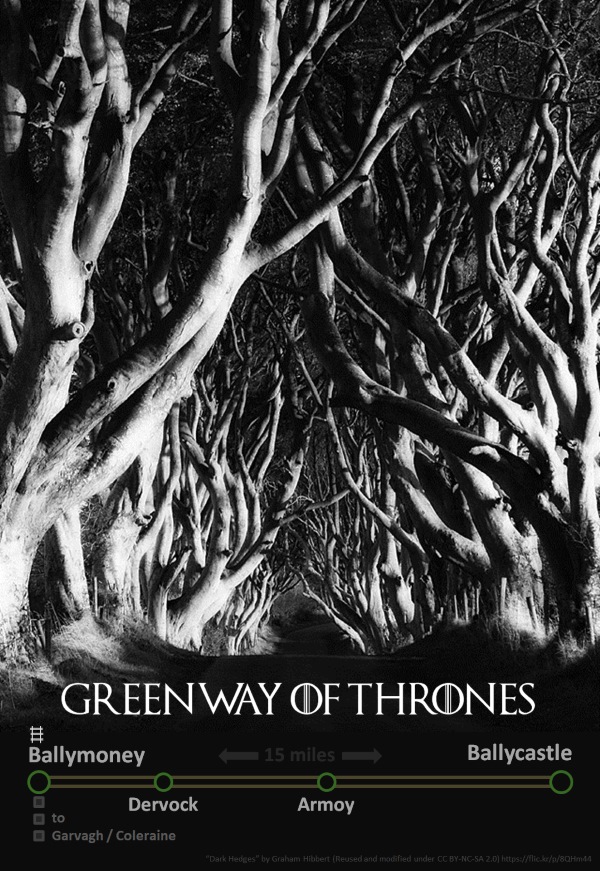
The spectacular Dark Hedges near Armoy in County Antrim provided a perfect natural set for the Kingsroad in Game of Thrones. However a piece of hidden history could build on the Game of Thrones tourism boost. A small stone bridge marks the old Ballymoney to Ballycastle railway line, and potential future greenway.
Game of Thrones, HBO’s international hit series filmed in Northern Ireland, is creating a new tourism market. Several memorable locations are dotted around the Causeway Coast, including recent filming for Game of Thrones Series 5 in nearby Portstewart. With the series expected to continue production and be on our screens for several years, and the large loyal following for the original book series by George R.R. Martin, experience tourism for Game of Thrones in Northern Ireland will continue to provide an important niche in the local economy.
https://twitter.com/G_O_T_fans/status/461872846802014208
The Dark Hedges has always been a spectacular location for North Coast visitors, and its inclusion as a section of the epic Kingsroad running through Westeros in the Game of Thrones television series adds a unique selling point to a great opportunity for the local economy..
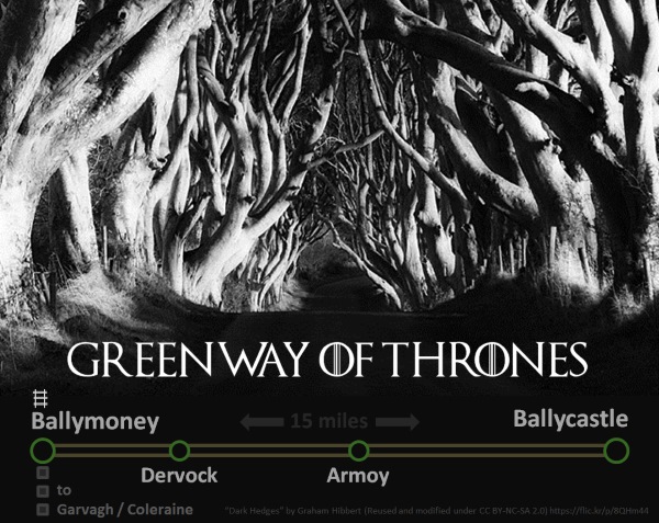
Ballymoney to Ballycastle Greenway
The Ballycastle Railway opened in 1880 running between Ballymoney to Ballycastle. It was a narrow gauge railway which operated passenger and freight services for almost 70 years until it was closed by the Ulster Transport Authority 1950. Ballycastle’s position as a seaside town meant a boost from the tourist traffic generated by the railway. The current drive across Ireland to re-open derelict railway lines as walking and cycling pathways (and as successful rural regeneration schemes) makes a compelling case for developing a Ballymoney to Ballycastle Greenway.

Ballymoney is a great starting place for the greenway for a number of reasons:
- a large town population
- the railway station linking Ballymoney with Belfast and Derry~Londonderry
- an existing traffic-free path running from railway station to proposed greenway
- the future plans to upgrade A26 to Coleraine which should create a quality cycle route to Causeway Coast
The Riverside Park pathway is a great facility for local residents in Ballymoney, which shadows the footprint of the old railway line where it diverges from the current track.

The old line is now cut by the Frosses Road bypass (see the tree line to the right of the blue sign above) but it continues northwards on the far side, under Kirk Road before running parallel to Knock Road..

This enchanting view makes a greenway easy to visualise, however a common problem on abandoned railways is seen under the beautiful stone bridge..

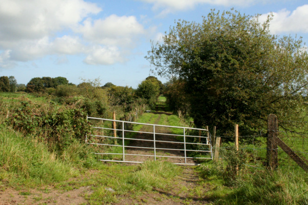
Further along, the trackbed has become a working lane for local farmers, as the line crosses Conogher Road..
The line continues across farmland and the Bush River before turning East as it skirts the edge of the village of Dervock. A sign for “Station Road” gives away the history of the area, but otherwise there are few remnants of the railway here today. The experience of the Great Western Greenway in Mayo has seen great transformation with thousands of otherwise unexpected tourists bringing business and local employment opportunities to small rural settlements.
The undulating treeline of the railway is clearly visible on Google Maps heading towards the next road crossing, with an impressive bridge at Mostragee Road..

As with a number of points along the abandoned railway, housing development since the closure may require route diversions during any greenway development. Crossing the Ballinlea Road the old line heads towards the first highlight for potential greenway users.
The Dark Hedges / Kingsroad
At almost the halfway point between Ballymoney and Ballycastle the line passes underneath the Bregagh Road. In the 18th century the Stuart family planted this row of beech trees on the approach to Gracehill House, and the Dark Hedges have grown to become a world-famous visual spectacle. On the southern end a small stone bridge goes largely unnoticed by visitors, yet steam trains thundered past here over 130 years ago.
In the Game of Thrones television series, the Dark Hedges was transformed into a spectacular section of the Kingsroad, where King Robert Baratheon marches to King’s Landing with a combustible party of Starks, Lannisters and assorted destestable characters.

The Dark Hedges already attracts tens of thousands of visitors each year, which creates some problems given the limited parking (a car is the only realistic way of reaching the area) and ongoing issues with environmental damage, due in part to not catering for the reality of this iconic tourist attraction..
“The site should at least be made a conservation area and the footprint extended to include the land on either side of the trees, the historically important Gracehill House and the dismantled Ballymoney to Ballycastle narrow gauge railway – which has great potential as a cycle route/walkway.”
Photographer Bob McCallion interviewed in the Ballymoney and Moyle Times (May 2014)

Working with the local landowners to address these problems in conjunction with creating a new traffic-free access for visitors could benefit the whole area.
The line continues towards Armoy with an embankment section leaving this impressive bridge abutment visible at Chatham Road..

Like Dervock, Armoy stands to benefit from local and external tourism traffic passing through all year round. It’s already home to the world-famous Armoy Road Races in mid summer, where the start / finish line at the Hillside Road coincidently is at a point where the old railway line runs right beside the road.
An embankment is visible to the west of the Hillside Road as the line head north east towards Capecastle. It’s here we find another wonderful attraction of the old railway and any future greenway – the Capecastle Tunnel.

The tunnel is 66 yards long, visible near the junction of Islandarragh Road and Hillside Road where the old Capecastle Railway Station was sited. The stonework is in fine shape, but the trackbed itself is covered in water.

Restoring this tunnel to its former glory by allowing walkers and cyclists to travel through it as part of a future greenway would be an excellent attraction..

The old line continues through cuttings and embankments under the shadow of Knocklayd(e) Mountain, with several crumbling embankments visible from Hillside Road. As the line falls towards the coastline, we meet the Moyle Way – emerging as a forest trail which then makes use of the trackbed on the sweep down to Ballycastle town. The path emerges at Fairhill Street under a beautiful stone bridge..

Another magical grassy pathway leads from the other side of Fairhill Road towards the town centre, almost pleading with you to take a dander..

Before the old railway line terminated at Ballycastle Railway Station the small matter of the Tow River had to be crossed – a stone arch viaduct, mostly hidden from public view, stands as a proud testament to our engineering heritage – worthy of being the centre of redevelopment. It’s particularly odd that the last Ballycastle Town ‘masterplan’ (2009) didn’t even reference the viaduct – many other towns would celebrate and protect this type of gateway..
https://www.facebook.com/ballynahinchjunction1950/photos/a.573523122742998.1073741841.312792468816066/573523596076284
Finally the old railway station is now the town’s Ulsterbus station, is a little less glamorous than its railway predecessor with sad derelict reminders of past glories..
@nigreenways great photo. Nothing but opportunity here. End of the line or maybe the beginning? #Ballycastle pic.twitter.com/ItwDQDmrOl
— Damian McAfee (@maccatweet) September 7, 2014
Is a Ballymoney to Ballycastle Greenway possible?
Like any potential greenway project, land access is the biggest hurdle, as explained by Northern Ireland’s Regional Development Minister Danny Kennedy:
“Unfortunately, the majority of the track bed of the former Ballymoney to Ballycastle railway line was sold to numerous parties in and around the mid- to late-1950’s. The only portion of the track now left in Translink ownership is the part which now houses the bus station in Ballycastle.”
Regional Development Minister Danny Kennedy in response to AQW34586 by Daithí McKay
The experience of many greenways across the UK and Ireland is that solutions can be found if the community and landowner will is there to see it done. Although the particular model may not transfer, it’s remarkable that over 160 farmers and landowners co-operated to allow the Great Western Greenway in Mayo become a reality and success..
“It is amazing what can be done if everyone in a community pulls together.”
Great Western Greenway submission to Northern Ireland Regional Development Committee
No doubt the challenges to seeing a fully-realised greenway from Ballymoney to Ballycastle will be sizeable. But the project has a number of natural advantages:
- traffic-free pathways already at each end
- a natural tourist draw at the Dark Hedges (and the wider Causeway Coast)
- the railway connection at Ballymoney
- a well-developed tourism economy in Ballycastle
Local entrepreneurship is shown to be stimulated by this type of investment, with bike hire, cafés and craft shops being an obvious and viable step for people looking to start their own business. Greenways have a pleasant habit of providing younger generations in rural communities with an alternative to moving away from the area to find employment.
Projects like this need to be driven from within an enthusiastic local community, and that is the next step. The Game of Thrones tourism link, along with some spectacular natural and human-made points of interest give the Ballymoney to Ballycastle Greenway a great chance of getting off the ground. If local residents, farmers, landowners, community groups, regeneration organisations and politicians can see the potential, we may yet be able to create the Greenway of Thrones.
Explore the remnants of the Ballycastle railway trackbed on Google Maps..
[googlemaps https://www.google.co.uk/maps/ms?msa=0&msid=202802535379582075161.00050578433a096f470ba&hl=en&ie=UTF8&t=h&ll=55.140032,-6.39473&spn=0.156987,0.411301&z=11&output=embed&w=600&h=400]
Greenway prospecting along 3 abandoned NI railway lines yesterday #stunning @DiscoverNI @SustransNI pic.twitter.com/mn8QviltRQ
— NI Greenways (@nigreenways) September 12, 2014