ENNISKILLEN TO SLIGO GREENWAY
“Marble Arch Greenway”
A 72km route heading west from Enniskillen, under the shadow of Belmore Mountain, turning through Belcoo / Blacklion and on towards Sligo.
ROUTE DETAILS
| Length | 72 kilometres |
| Estimate | £11 million |
| Timescale | 2018 to 2026 |
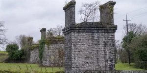
| Type | Former railway |
| Title | Sligo, Leitrim and Northern Counties Railway |
| Border area | Yes |
| Councils | Fermanagh and Omagh District Council |
| Leitrim County Council | |
| Sligo County Council |

IMAGES


PROGRESS UPDATES
Idea stage
Feasibility
Construction
Completed
RESOURCES ELSEWHERE
Arlene Foster champions the Sligo to Enniskillen Greenway on the Late Late Show (RTE)
A greenway plan across rail route could be tourism gem (The Sligo Champion)
Greenway cycle route from Sligo to Enniskillen pedals on to second stage (The Impartial Reporter)
Sixty years since Fermanagh’s trains came to a shuddering stop (BBC NI)
Sixty years since Border rail transport ran out of steam (The Irish Times)
Exercise Explore Enjoy: A Strategic Plan for Greenways (Department for Infrastructure) PDF 2.8MB
Strategic Plan for Greenways Base Report (AECOM, Sustrans, DfI) PDF 15.7MB
GREENWAY PROJECTS WHICH INTERSECT
ENNISKILLEN TO CLONES GREENWAY
A 35km route heading southeast out of Enniskillen along Upper Lough Erne passing Maguiresbridge and Linsaskea before turning into Clones.

Former railway route 43km south from Omagh passing Fintona and the junction to Bundoran before going through Ballinamallard into Enniskillen.
GET INVOLVED
Successful greenway projects are driven by the passion of local people. If you have an update to share, a story to tell about the history of the route or future of the Enniskillen to Sligo Greenway, or if you want to submit a picture or video to this page, please get in contact.