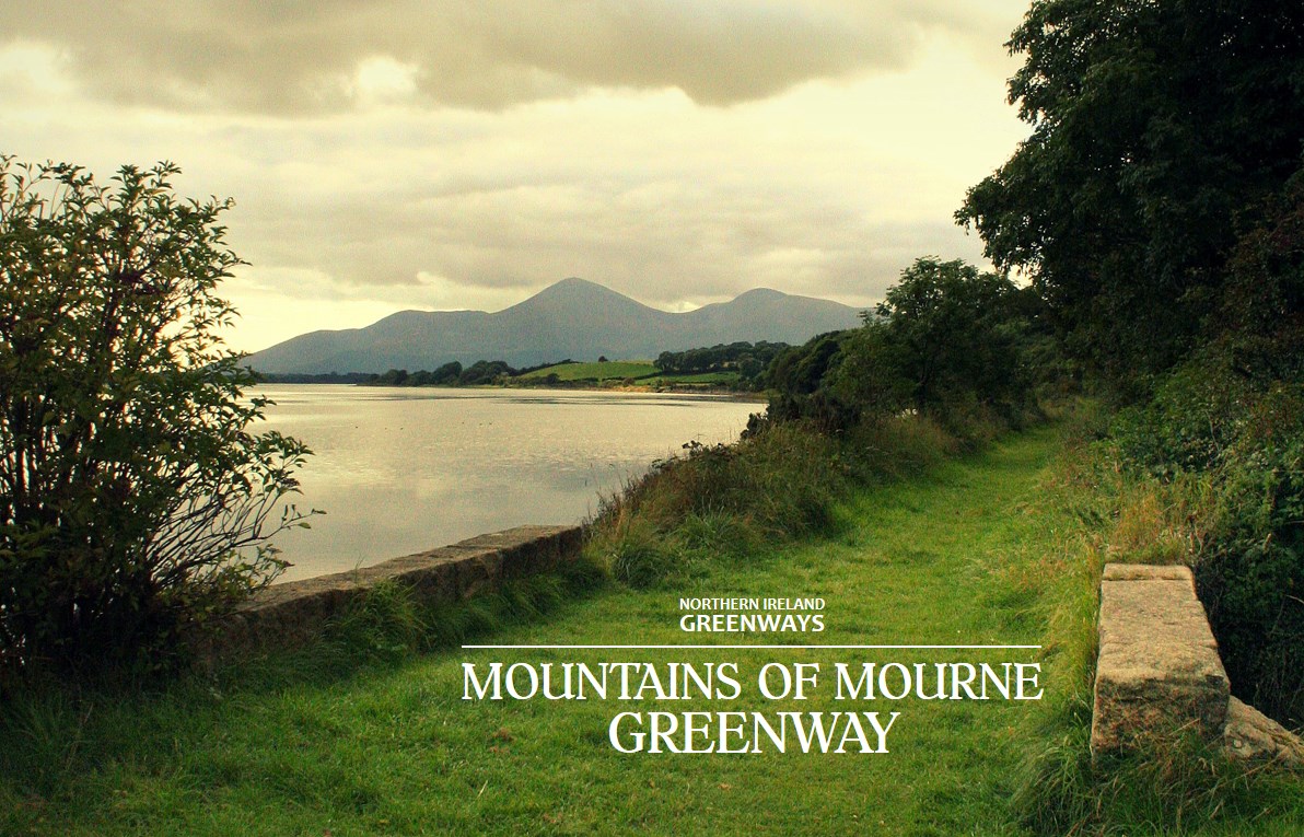
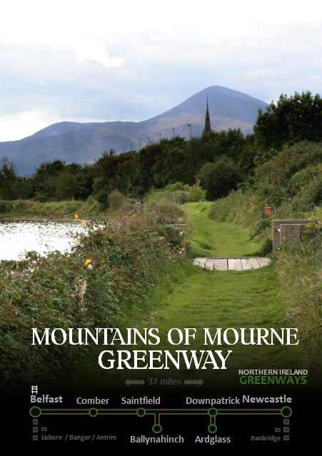
The first flourish of railway development in Ireland 150 years ago helped to establish towns like Newcastle into prime seaside tourist locations. While Bangor and Portrush still benefit from active railway links, Newcastle lost its rail connection in the 1950s. The time is right to build a 37 mile greenway sweeping from Belfast to the Mourne Mountains, to reimagine this once thriving tourist route.
The Comber Greenway, our most well-known traffic-free pathway, is almost a decade old in its current form. Stretching the seven miles from the centre of Belfast to Comber it provides wonderful access to the countryside for urban dwellers and commuting options for rural and suburban dwellers.
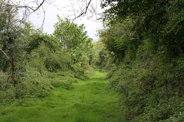
It was built on the track bed of the former Belfast and County Down Railway (BCDR) thankfully instead of a motorway. But the BCDR had operated 80 miles of railway, with five branches and the ‘mainline’ which stretched from Belfast all the way to Newcastle. It’s this mainline which fires the imagination for development of a greenway from the big city to the big mountains.
Old trackbed outside Comber going to Downpatrick, what chance a new greenway? http://t.co/geC5FP8xSw http://t.co/R5nb8EBreq
— NI Greenways (@nigreenways) July 15, 2013
A Mountains of Mourne Greenway could stretch fully 37 miles from Belfast centre to Newcastle, passing through the towns of Comber, Ballygowan, Saintfield and Downpatrick. Two further branch lines to Ballynahinch and Ardglass takes this vision to a 50 mile network for leisure, tourism and utility cycling and walking.

The relatively short distances between the main population centres (Comber, Ballygowan, Saintfield and Ballynahinch are in a line 13 miles long, while Downpatrick is just under 10 miles from both Newcastle and Ballynahich) creates strong potential for commuting to workplaces, short leisure trips and a practical alternative to using a private car for town-to-town travel.

The track bed along the majority of the route is relatively intact, with the occasional section taken over for farmland over the last half century. Ballygowan and Saintfield, in the outer orbit of Belfast, stand to gain the kind of direct benefit to the local economy experienced in Comber as a result of a direct traffic-free link to the city.
The beautiful Rowallane Garden on the southern edge of Saintfield is roughly 14 miles from Belfast by the proposed greenway route, making it well within reach for family outings by bicycle.

The line continues south through Crossgar providing more town-to-town cycling options for locals. From Crossgar to Downpatrick several sections of the old line have been retained as dirt roads and private pathways which have the potential to be repurposed into high-quality greenway.

The route enters Downpatrick across the Quoile river, joining Northern Ireland’s only working heritage railway, the Downpatrick and County Down Railway. A link up with the heritage railway project is a fantastic opportunity to highlight a major tourist attraction, which can provide education on the history of the route of the new greenway.

Downpatrick itself boasts Inch Abbey, Down Cathedral, regarded as Saint Patrick’s burial place, as well as the Saint Patrick Centre and the Down County Museum.
Leaving Downpatrick the line passes through Ballydugan with the award-winning Lakeside Inn and The Mill at Ballydugan hotel, in prime position to be boosted by greenway users.

Through Tullymurry lies an area of more recent historical significance with World War I training trenches dug into the Down countryside at Ballykinlar, as featured in Barra Best’s BBC NI series Walk The Line.
Between Downpatrick & Newcastle @Barrabest finds an army camp steeped in history #WalkTheLine http://t.co/BxRheO7XAo pic.twitter.com/oAqxN24CAU
— BBC Northern Ireland (@BBCnireland) October 11, 2014
Approaching Dundrum the tourism value of the greenway project begins to unfold in a big way. The Dundrum Coastal Path is an existing National Trust trail which utilises the old railway line as part of the wider 47 mile Lecale Way.


Former Belfast and County Down Railway ©nigreenways
Dundrum Bay lies at the edge of the Murlough Bay Nature reserve. The railway line cuts across the bay as a couple of points, and one of bridges constructed to carry the constant flow of ramblers even includes original sleepers and rails. This spectacular section would need a sympathetic upgrade to greenway standard.

The route passes into Dundrum town, a wonderful stop-off for lunch on a day-trip down the greenway, including the internationally renowned Mourne Seafood Bar. Leaving the village, the line crosses the bay by bridge, with beautiful scenery as the Mourne Mountains begin to loom large.
@nigreenways Bugger off I fish along there in the summer, #bloodycyclists ringing their bells at me 🙂 It would be awesome though
— Chasing Silver (@chasingsilver1) September 17, 2015
Continuing its winding path south west, the landscape changes to grassy dunes as it approaches the outskirts of Newcastle. Murlough Nature Reserve is the site of a popular sand dune beach for locals and tourists alike, and the nearby caravan park would benefit from direct traffic-free access to Newcastle town centre.
Slieve Donard Hotel boasts electric light throughout and salt water baths#summerholiday #Down
Advert in @irish_news pic.twitter.com/v1ryHgeZJn— BBC Voices 16 (@BBCVoices16) July 11, 2016
The line skites between Royal County Down Golf Club (originally developed with BCDR assistance) and residential streets before ending at the Slieve Donard Resort and Spa and the old train station which still stands today.
Newcastle and the surrounding area is a wonderful leisure location for short breaks by tourists and staycationers alike. Short stay accommodation availability lends itself well to a stop-off on a cycling tour holiday of the type Northern Ireland could successfully promote with a fully traffic-free greenway network. The outdoor activity market is rich in the area, with the Mourne Mountains providing hiking and mountain biking trails and the excellent Tollymore National Outdoor Centre nearby.
Beautiful scenery, thrilling leisure activities, great restaurants, welcoming cafes, cosy pubs and world-class accommodation – building a greenway from Belfast to Newcastle is a signature tourism project which will promote the best we have to offer to the world and drive significant economic redevelopment in this part of the country.
Ballynahinch Branch
The town of Ballynahinch lies on the man road between Belfast and Newcastle and is notorious for traffic congestion. Running a greenway spur from the mainline at Ballynahinch Junction would offer some options for modal shift towards Saintfield and Comber to the north and Downpatrick to the south.

A proposed road bypass of the town could cause issues for the preservation of a potential greenway route. A grade-separated junction slated for the exact spot where the railway line passes under the Crossgar Road (picture above) and should the bypass go ahead, a greenway underpass should be designed in to ensure future development.
Ardglass Branch
The former branch line to the fishing town of Ardglass is eight miles from Downpatrick. This section has been taken over by farming and development to a greater extent than the mainline, but local benefit could be derived from extending the greenway network to the coast.

There is an opportunity for renovation and renewal of a coastal bridge on the outskirts of the village, a direct path to the Coney Island Caravan Park, and a chance to further promote the area to users of the marina.

The old railway station still exists, standing beside a fish processing plant and crying out for some tender love and care – or a nice cafe at the end of a long cycle from the big smoke.
Please leave your thoughts on the potential for a Mountains of Mourne Greenway in the comments section below and share using the social media buttons 🙂
@EssenceHealthNI @nigreenways It would be great for Newcastle. Very successful initiative in Republic.
— Yvette Shapiro (@yvetteshapiro) April 28, 2015
“@nigreenways: A dander or cycle from Downpatrick to Ardglass? The former railway line could be developed as a greenway" – Already on it!
— VisitStrangfordLough (@visitstrangford) October 13, 2014
@nigreenways Downpatrick to Newcastle! Love the Mournes!
— Barton Creeth (@bartoncreeth) May 18, 2012